Optima Lake facts for kids
Quick facts for kids Optima Lake |
|
|---|---|

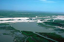
Optima Lake and Dam
|
|
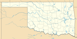
| Location | Texas County, Oklahoma |
| Coordinates | 36°39′42″N 101°08′12″W / 36.66167°N 101.13667°W |
| Type | reservoir |
| Basin countries | United States |
| Surface elevation | 2,766 feet (843 m) |
| Settlements | Hardesty, Oklahoma |
Optima Lake is a special place in Texas County, Oklahoma. It was built to be a reservoir (a big, artificial lake) to hold water. You can find it north of Hardesty and east of Guymon, in the part of Oklahoma called the Oklahoma Panhandle.
The Optima Lake Dam is a large earthen dam. It was finished in 1978 by the United States Army Corps of Engineers. The dam is 120 feet tall and over 16,000 feet long at the top.
Even though it was designed to hold a lot of water, the lake never filled up. It has never reached more than 5% of its planned size. This happened because the main river that was supposed to fill it, the Beaver River, had much less water than expected. This was due to a lot of water being pumped from an underground water source called the Ogallala Aquifer.
Because the lake is often empty, there isn't much water-based fun to be had. The US Army Corps of Engineers says:
"Visitors should be aware that the lake's level can be very low. Depending on rainfall and evaporation rates, the lake may offer no water-based recreation and may not be suitable for swimming, fishing, boating or other activities. Visitors should come for the quiet natural setting--with or without water in the lake area."
Many of the old camping spots and buildings were taken down in 2010 for safety reasons.
Contents
Why Was Optima Lake Built?
The idea for Optima Lake started a long time ago, back in the 1930s. It was part of a plan to control floods and help people in the dry Oklahoma Panhandle. The lake was supposed to provide drinking water, water for farms, and a place for recreation. It was also meant to help fish and wildlife.
Planning and discussions took many years. Construction finally began in 1966.
The Beaver River's Role
The main source of water for the lake was supposed to be the Beaver River, also known as the North Canadian River. Before the dam was built, the river usually had a good amount of water flowing. Sometimes, it even had big floods. For example, in 1923, there was a huge flood.
Local groups, like the Guymon Chamber of Commerce, were very excited about the lake. They thought it would be 100 feet deep. They also believed its "arms" would stretch far up the Beaver River and a smaller stream called Coldwater Creek.
The Lake That Never Filled
During the 12 years it took to build the dam, something unexpected happened. The flow of the Beaver River started to drop.
Engineers later realized that the Beaver River gets its water from the Ogallala Aquifer. This is a huge underground water source that stretches across many states. More and more water was being pumped from this aquifer for farming and drinking. This caused the river's flow to become very small.
The $46.1 million project was finished in 1978. The dam was built with compacted earth. It has gates to control water and a spillway for extra water.
Hopes for Visitors
Even in 1979, the Corps of Engineers was hopeful. They thought the lake would attract 600,000 visitors every year by 2014.
But the water flow in the Beaver River kept getting lower. From 1977 to 1987, the river's flow was much less than its historical average. By the mid-1980s, the Corps realized the river's reduced flow was permanent. The lake was not going to fill up. The highest the lake ever got was still below the very bottom of its planned "conservation pool" level.
By the early 1990s, the Beaver River near Guymon had almost no water flowing in it.
Optima Lake Today
The park at Optima Lake was officially closed in 1995. However, the area is still open to the public.
Around 2010, many old structures like picnic areas and restrooms were torn down. This was done for safety reasons because they were falling apart. As of 2014, the site gets only a few thousand visitors each year.
The dam structures are still checked regularly. They are in good working condition.
The "Dry Lake" Idea
When the lake was being planned, engineers thought about a "dry lake" option. This meant the area would not hold water normally. Instead, it would only fill up during very big floods. This idea was rejected at the time. However, the lake as it exists today works much like that "dry lake" plan.
The Beaver River still carries floodwaters sometimes. For example, in April 2016, after heavy rains, the river flowed near Guymon for the first time in decades.
Wildlife and Nature Areas
The Optima Lake project also includes important natural areas.
- The Optima National Wildlife Refuge is managed by the United States Fish and Wildlife Service. It covers a large area along Coldwater Creek. This refuge helps protect many different kinds of wildlife.
- The Optima Wildlife Management Area is managed by the Oklahoma Department of Wildlife Conservation. It provides public hunting lands along the Beaver River.
Because the lake itself is so small, the size of these wildlife areas has actually grown. They now cover thousands of acres.
 | John T. Biggers |
 | Thomas Blackshear |
 | Mark Bradford |
 | Beverly Buchanan |


