Berkley, Colorado facts for kids
Quick facts for kids
Berkley, Colorado
|
|
|---|---|

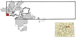
Location of the Berkley CDP in Adams County, Colorado.
|
|
| Country | |
| State | |
| County | Adams County |
| Government | |
| • Type | unincorporated community |
| Area | |
| • Total | 4.089 sq mi (10.590 km2) |
| • Land | 3.600 sq mi (9.323 km2) |
| • Water | 0.489 sq mi (1.267 km2) |
| Elevation | 5,210 ft (1,588 m) |
| Population
(2020)
|
|
| • Total | 12,536 |
| • Density | 3,065.92/sq mi (1,183.76/km2) |
| Time zone | UTC-7 (MST) |
| • Summer (DST) | UTC-6 (MDT) |
| ZIP Code |
Denver 80221
|
| Area codes | 303 & 720 |
| GNIS feature | Berkley CDP |
Berkley is a community in Adams County, Colorado, in the United States. It is not an official city or town. Instead, it is called an "unincorporated community." This means it does not have its own local government.
Berkley is also a "census-designated place (CDP)". This means the United States Census Bureau counts it as a separate area for population numbers. Berkley is part of the larger Denver metropolitan area. In 2020, about 12,536 people lived there. The Denver post office with ZIP code 80221 serves the Berkley area.
Geography of Berkley
Berkley is located in the state of Colorado. It covers an area of about 10.59 square kilometers (about 4.09 square miles). A small part of this area, about 1.27 square kilometers (0.49 square miles), is water.
Population Over Time
The United States Census Bureau first officially counted Berkley as a CDP for the United States Census 2000. The population has grown steadily over the years.
| Berkley CDP, Colorado | ||
|---|---|---|
| Year | Pop. | ±% |
| 2000 | 10,743 | — |
| 2010 | 11,207 | +4.3% |
| 2020 | 12,536 | +11.9% |
| Source: United States Census Bureau | ||
See also
 In Spanish: Berkley (Colorado) para niños
 | Janet Taylor Pickett |
 | Synthia Saint James |
 | Howardena Pindell |
 | Faith Ringgold |


