
Bennett, Colorado facts for kids
Quick facts for kids
Bennett, Colorado
|
|
|---|---|

Bennett skyline (2007)
|
|

|
|
| Country | |
| State | |
| Counties | Adams County Arapahoe County |
| Incorporated (town) | January 22, 1930 |
| Government | |
| • Type | Statutory Town |
| Area | |
| • Total | 5.801 sq mi (15.024 km2) |
| • Land | 5.795 sq mi (15.008 km2) |
| • Water | 0.006 sq mi (0.016 km2) |
| Elevation | 5,485 ft (1,672 m) |
| Population
(2020)
|
|
| • Total | 2,862 |
| • Density | 494/sq mi (191/km2) |
| Time zone | UTC−07:00 (MST) |
| • Summer (DST) | UTC−06:00 (MDT) |
| ZIP code |
80102
|
| Area codes | Both 303 and 720 |
| FIPS code | 08-06090 |
| GNIS feature ID | 204738 |
Bennett is a small town in Colorado, United States. It is special because it is located in two different counties: Adams County and Arapahoe County. In 2020, about 2,862 people lived there. Most of the residents lived in Adams County.
Contents
History of Bennett
Bennett became an official town on January 22, 1930. It was named after Hiram Pitt Bennet. He was an important leader who represented the Territory of Colorado in Congress. He also served as the Colorado Secretary of State.
Where is Bennett Located?
Bennett is located in Colorado at 39°45′13″N 104°25′43″W / 39.75361°N 104.42861°W. You can find it where two state highways, Highway 36 and Highway 79, meet. It is also just north of Interstate 70.
The town covers an area of about 14.4 square kilometers (about 5.6 square miles). Only a very small part of this area is water. Bennett once held the record for the highest temperature ever recorded in Colorado. On July 11, 1888, the temperature reached a very hot 118 degrees Fahrenheit (48 degrees Celsius).
People Living in Bennett
The number of people living in Bennett has grown over the years. Here is how the population has changed:
| Historical population | |||
|---|---|---|---|
| Census | Pop. | %± | |
| 1930 | 211 | — | |
| 1940 | 199 | −5.7% | |
| 1950 | 272 | 36.7% | |
| 1960 | 287 | 5.5% | |
| 1970 | 613 | 113.6% | |
| 1980 | 942 | 53.7% | |
| 1990 | 1,757 | 86.5% | |
| 2000 | 2,021 | 15.0% | |
| 2010 | 2,308 | 14.2% | |
| 2020 | 2,862 | 24.0% | |
| U.S. Decennial Census | |||
Bennett is part of a larger area called the Denver-Aurora-Lakewood, CO Metropolitan Statistical Area. This means it is connected to the bigger cities of Denver, Aurora, and Lakewood. It is also part of the Front Range Urban Corridor.
In the year 2000, there were 2,021 people living in Bennett. These people lived in 715 different homes. Many homes (49.2%) had children under 18 living there. Most homes (58.3%) were married couples living together.
The average age of people in Bennett in 2000 was 31 years old. About 34.5% of the population was under 18 years old.
Famous People from Bennett
- Hiram Pitt Bennet (1826–1914): He was a political leader who represented Colorado in the U.S. Congress. He also served as Colorado's Secretary of State. The town of Bennett was named after him.
- Tim Samaras (1957–2013): He was an engineer and a storm chaser. He became well-known for appearing on the TV show Storm Chasers on the Discovery Channel.
Images for kids
-
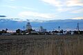
Bennett skyline (2007)
-
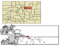
Location of Bennett in Adams and Arapahoe counties of Colorado
See also
 In Spanish: Bennett (Colorado) para niños
