Leader, Colorado facts for kids
Quick facts for kids
Leader, Colorado
|
|
|---|---|

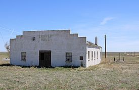
The community hall in Leader.
|
|
| Country | |
| State | |
| County | Adams |
| Elevation | 4,864 ft (1,483 m) |
| Time zone | UTC-7 (MST) |
| • Summer (DST) | UTC-6 (MDT) |
| GNIS feature ID | 184655 |
Leader is a small, quiet place located in Adams County, Colorado, in the United States. Even though it's a quiet spot now, Leader used to be a busy community with its own post office, a school, and a special community hall where people gathered.
Contents
Where is Leader, Colorado?
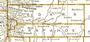
Leader is found in the state of Colorado. It is about 12 miles northeast of a town called Byers. The area is located at coordinates 39°53′58″N 104°03′23″W / 39.89944°N 104.05639°W. This means it's in the northern part of the Western Hemisphere. Leader sits at an elevation of about 1,483 meters (4,864 feet) above sea level.
A Look at Leader's Past
Leader has an interesting history, even though it's a small place. Many years ago, it was a lively community.
Early Days and Community Life
The first post office in Leader opened its doors in 1910. It helped people send and receive letters and packages until it closed in 1940. This shows how important mail was for connecting people in the past.
In 1916, a local group called the Grange started a chapter in Leader. It was known as United Farmers #288. The Grange was a community organization for farmers and their families. They worked together to solve problems and support each other.
Wildlife Challenges for Farmers
In its early years, Leader was known for having many prairie dogs and ground squirrels. While these animals are part of nature, they caused big problems for farmers. They were very destructive to important crops like corn, peanuts, and beans. Farmers had to work hard to protect their harvests.
The Leader Community Hall
The Leader Community Hall was built in the 1940s. This building was a very important place for everyone in Leader. It was used for many different community events, like meetings, parties, and gatherings. It also served as a place where people could go to vote during elections. Even in the 1970s, the hall was still active, with a group of women forming the Leader Community Hall Ladies auxiliary to help keep it running.
Population and Local Discoveries
In 1940, Leader had a small population of just 19 people. This shows it was a very close-knit community. Later, in the 1950s, something exciting happened near Leader: oil was discovered! News reports called these "major" new oil reserves. Oil drilling began on the Burkhart Ranch in 1954. This discovery brought new activity and attention to the area.
The One-Room Schoolhouse
Leader also had its own school, which was a one-room schoolhouse. This means all the students, no matter their age, learned together in one classroom with one teacher. The Leader School operated until 1956. After that, schools in Adams County were combined. Students from Leader then took a bus to Byers, which was about 12 miles away, to continue their education.
 | Toni Morrison |
 | Barack Obama |
 | Martin Luther King Jr. |
 | Ralph Bunche |


