Hoosier Pass facts for kids
Quick facts for kids Hoosier Pass |
|
|---|---|

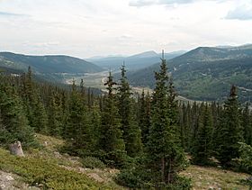
View south from Hoosier Pass, towards Alma
|
|
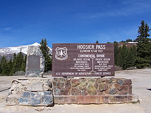
| Elevation | 11,542 ft (3,518 m) |
| Traversed by | |
| Location | Park / Summit counties, Colorado, U.S. |
| Range | Mosquito Range |
| Coordinates | 39°21′42″N 106°03′45″W / 39.36167°N 106.06250°W |
| Topo map | USGS Alma |
Hoosier Pass is a high mountain pass in the middle of Colorado, located in the famous Rocky Mountains of the western United States. It sits at an elevation of about 11,542 feet (3,518 meters) above sea level. The pass got its name from Indiana, often called the "Hoosier State." Many early settlers who came to this area were originally from Indiana.
Contents
Where is Hoosier Pass?
This pass is found right on the Continental Divide. This is a line that separates which ocean rivers flow into. Water on one side flows to the Pacific Ocean, and water on the other side flows to the Atlantic Ocean.
Hoosier Pass is at the northern end of the Mosquito Range of mountains. It sits in a natural gap between Mount Lincoln to the west and Hoosier Ridge to the east. The pass also marks the border between two counties: Park County to the south and Summit County to the north.
Traveling Over the Pass
Hoosier Pass offers a route between two important river areas. To the north, you find the beginnings of the Blue River, which eventually flows into the Colorado River. To the south, you find the beginnings of the South Platte River in an area called South Park.
State Highway 9 crosses over the pass. This highway connects the town of Breckenridge to the north with Fairplay to the south.
The highway over Hoosier Pass is a useful way to get from Denver to popular ski areas like Breckenridge and Keystone. It is usually open all year round. Most vehicles can use it in good weather. However, it sometimes closes during big winter snowstorms. The road going up the south side of the pass is smooth. But the north side has several sharp turns called switchbacks. This part of the road is quite steep, with an 8% grade.
Hoosier Pass is also the highest point on the TransAmerica Trail. This is a very long bicycle route that goes all the way across the United States. It stretches from Yorktown, Virginia to Astoria, Oregon.
Moving Water Across the Divide
Hoosier Pass is known for one of the oldest projects in Colorado that moves water from one river basin to another. This is called a transbasin diversion. Long ago, a ditch was built to move water from a small stream that fed the Blue River. This water was then sent to the Middle Fork of the South Platte River. This moved water across the Continental Divide. The water was used for placer mining near Alma.
By 1929, two ditches were working: the 1.8-mile (2.9 km) East Hoosier Ditch and the 1.3-mile (2 km) West Hoosier Ditch. These ditches could move a lot of water. Later, the city of Colorado Springs bought the rights to this water. They built the Hoosier Pass Tunnel to replace the old ditches.
This large water tunnel is 10 feet (3 meters) wide and 1.5 miles (2.4 km) long. It was finished in 1951. The tunnel can deliver a huge amount of water to the Montgomery Reservoir. This reservoir is about a mile southwest of the pass. From there, the water travels through pipes for 70 miles (113 km) to Colorado Springs. On average, about 9,000 acre-feet (11 million cubic meters) of water are moved through the tunnel each year.
Another Hoosier Pass
There is another place called Hoosier Pass in Colorado. This other pass is located in Teller County, near Cripple Creek. It is at a lower elevation of about 10,313 feet (3,143 meters).
 | Toni Morrison |
 | Barack Obama |
 | Martin Luther King Jr. |
 | Ralph Bunche |


