Trout Creek Pass facts for kids
Quick facts for kids Trout Creek Pass |
|
|---|---|

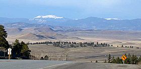
View from Trout Creek Pass
|
|
| Elevation | 9,487 ft (2,892 m) |
| Traversed by | |
| Location | Chaffee / Park counties, Colorado, U.S. |
| Range | Mosquito Range |
| Coordinates | 38°54′36″N 105°58′30″W / 38.91000°N 105.97500°W |
| Topo map | USGS Antero Reservoir |
Trout Creek Pass is a mountain pass located in the Rocky Mountains of south-central Colorado, United States. A mountain pass is like a low spot or a gap between mountains that makes it easier to travel from one side to another. This pass is about 9,487 ft (2,892 m) high.
The pass sits at the southern end of the Mosquito Range. It is on the border between Park County and Chaffee County. To the east of the pass are the headwaters of the South Platte River, an area known as South Park. To the west are the headwaters of the Arkansas River.
You can travel through Trout Creek Pass using U.S. Highway 24 and U.S. Highway 285. These highways connect towns like Hartsel, Fairplay, and Buena Vista. Most cars and trucks can easily use this pass. It only closes during very bad winter snowstorms. The road leading to the pass from the north is gentle, while the south side has a moderate slope of about 5%.
A Curious Sign
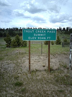
Interestingly, the elevation shown on the highway sign at the top of the pass (see the picture) seems to be wrong. It's off by about 140 ft (43 m) compared to what maps and other official information say.
How the Pass Formed
From a geology point of view, Trout Creek Pass is located on a fault. A fault is a crack in the Earth's crust where rocks have moved. This fault runs along the Mosquito Range. If you look at the rocks along the eastern side of the pass, you can see layers of black shale and thin gray limestone. These rocks were formed during a time called the Pennsylvanian Period, long before the Ancestral Rockies mountains were created.
These ancient rock layers were not pushed up as much as other areas when the Ancestral Rockies formed about 300 million years ago. Because they weren't uplifted as much, they also weren't worn away (eroded) as much as the surrounding areas.
History of Travel
Trout Creek Pass has been an important route for a long time. In 1879, the Denver, South Park and Pacific Railroad built a railway line over the pass. This was the first train connection between Denver and Leadville. This was a big deal during the Colorado Silver Boom, when many people were moving to Colorado to find silver.
Later, in the 1890s, another railway company called the Colorado Midland also built a line over Trout Creek Pass, connecting Colorado Springs to Leadville. However, both of these railway lines stopped being used in the 1920s.
Nature Around the Pass
Today, Trout Creek Pass is located within the beautiful San Isabel National Forest. This means the area is protected and offers many opportunities to enjoy nature, like hiking and exploring.
 | Janet Taylor Pickett |
 | Synthia Saint James |
 | Howardena Pindell |
 | Faith Ringgold |


