Geology of the Rocky Mountains facts for kids
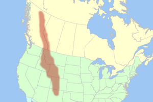
The geology of the Rocky Mountains is all about how these amazing mountains were formed. They are a long chain of mountain ranges that stretch from northern British Columbia in Canada all the way down to central New Mexico in the United States. These mountains are part of a much bigger system called the North American Cordillera.
The very old rocks at the heart of the Rocky Mountains are often more than a billion years old! Imagine that – rocks older than dinosaurs! In the southern parts, there was an even older mountain range that formed about 300 million years ago. This ancient range wore away over time, but its rocks were later used to build the Rocky Mountains we see today.
The Rocky Mountains got their shape during a very active time for Earth's plates. This period created much of the rugged land in western North America. A big event called the Laramide orogeny, which happened about 80 to 55 million years ago, was the main reason the Rocky Mountains rose up. After they formed, glaciers helped carve them into the beautiful shapes we see now.
Contents
Ancient Rocks of the Rockies
The rocks that make up the Rocky Mountains were already there long before the mountains themselves were pushed up. The oldest rocks are called Precambrian metamorphic rocks. These are super old rocks that form the very core of the North American continent. There are also ancient sedimentary rocks, like argillite, that are about 1.7 billion years old.
During a time called the Paleozoic Era, western North America was covered by a shallow sea. This sea left behind many layers of limestone and dolomite rocks, kilometers thick!
The Ancestral Rocky Mountains
In the southern part of the Rocky Mountains, near places like Colorado and New Mexico, these ancient rocks were disturbed about 300 million years ago. This was during a period called the Pennsylvanian. This disturbance created an older mountain range known as the Ancestral Rocky Mountains.
These ancient mountains formed two large islands, which geologists call Frontrangia and Uncompahgria. They were roughly where the Front Range and the San Juan Mountains are today. These islands were mostly made of very old Precambrian metamorphic rocks that were pushed up through the younger layers of limestone from the sea. Over millions of years, these mountains slowly wore away, leaving behind huge amounts of sedimentary rocks.
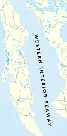
Later, during the Mesozoic Era, more layers of sediment were laid down in the Rockies. This happened in different environments, sometimes in the sea, sometimes near the coast, and sometimes on land, as sea levels changed. By the end of the Mesozoic, about 10,000 to 15,000 feet (3000 to 4500 meters) of new rock layers had piled up. Many of these non-marine (land-based) layers were formed during the Cretaceous period, when a large shallow sea called the Western Interior Seaway covered much of the western region.
How Continents Collided
Imagine giant puzzle pieces moving around on Earth's surface – these are tectonic plates. Sometimes, smaller pieces of land, called Terranes, crash into bigger continents. This started happening on the western edge of North America about 350 million years ago.
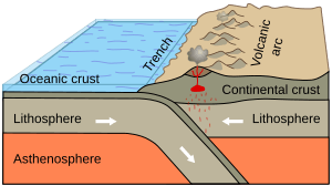
During the last half of the Mesozoic Era, much of what is now California, British Columbia, Oregon, and Washington was added to North America. This happened as the Kula plate and Farallon plate (two oceanic plates) slid beneath the edge of the continent. As they slid, they scraped off pieces of land, like small islands or parts of other continents, and added them to North America's western side.
These added land pieces, or terranes, came from different places. Some were old chains of volcanic islands, similar to Japan today. Others were pieces of the ocean floor that got pushed onto the continent.
As the oceanic plates sank deep into the Earth, the intense heat and pressure caused rock to melt, forming Magma. This molten rock rose up into the North American continent, about 200 to 300 miles (300 to 500 km) inland. This created huge, arc-shaped volcanic mountain ranges, like the Sierran Arc. Lava and ash burst out of many volcanoes, and large amounts of molten rock hardened underground.
For a very long time (about 270 million years), all this plate collision activity happened very close to the edge of the North American plate, far to the west of where the Rocky Mountains are now. It wasn't until about 80 million years ago that these powerful forces started to affect the Rocky Mountain region.
Raising the Rocky Mountains
The Rocky Mountains we know today were pushed up during an event called the Laramide orogeny, which happened between 80 and 55 million years ago. Think of it like pushing a rug on a smooth floor: the rug bunches up and forms wrinkles. In Canada, the sinking Kula plate and the land pieces crashing into the continent were like the feet pushing the rug. The ancient rocks were the rug, and the strong, stable Canadian Shield in the middle of the continent was the hard floor.
A Geological Puzzle
Further south, in the United States, how the Rocky Mountains grew is a bit of a puzzle for geologists. Usually, mountains form about 200 to 400 miles (300 to 600 km) inland from where an oceanic plate slides under a continent (a subduction zone). But the Rockies formed much farther inland!
Geologists are still gathering clues, but the most likely answer has to do with the Farallon plate sinking at a very unusual, flat angle. Normally, an oceanic plate sinks steeply. But during the time the Rockies formed, the Farallon plate might have slid almost flat under the North American continent. This flat angle would have greatly increased the rubbing and pushing between the sinking plate and the thick continent above it. This massive friction caused huge thrusts, where giant sheets of crust were pushed up and piled on top of each other. This created the incredibly wide and tall Rocky Mountain range.
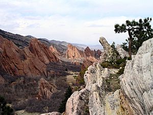
The southern Rockies were forced upwards through the old layers of rock that were left behind by the Ancestral Rocky Mountains. These old layers were often tilted at steep angles along the sides of the new mountains. You can still see them in many places today, like along the Dakota Hogback, which is a sandstone formation that runs along the eastern side of the modern Rockies.
The Mountains Today
Right after the Laramide orogeny, the Rockies were like a high plateau, similar to Tibet, probably about 6000 meters (20,000 feet) above sea level. But over the last 60 million years, erosion (wind, water, and ice wearing away rock) has stripped away the higher rocks. This process revealed the even older rocks underneath and shaped the Rocky Mountains into the landscape we see today.
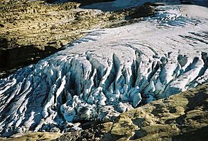
Periods of glaciation, or "ice ages," happened from about 1.8 million years ago until about 11,000 years ago. These ice ages left a huge mark on the Rockies. Massive glaciers carved out wide, U-shaped valleys and bowl-shaped hollows called cirques. Some recent ice ages include the Bull Lake Glaciation (starting about 150,000 years ago) and the Pinedale Glaciation (which was at its peak until about 15,000–20,000 years ago). For example, 90% of Yellowstone National Park was covered by ice during the Pinedale Glaciation! There was even a "little ice age" from about 1550 to 1860, when glaciers grew a bit larger again.
All these geological processes have left a complex mix of rocks visible on the surface. In the Colorado Rockies, you can find a lot of granite and gneiss from the Ancestral Rockies. In the central Canadian Rockies, the main peaks are made of ancient mudstones, while the front ranges are made of Paleozoic limestones and dolomites. Volcanic rocks from the Cenozoic Era (66 million to 1.8 million years ago) can be found in the San Juan Mountains and other areas.
Over millions of years, severe erosion in the Wyoming Basin turned the areas between mountains into relatively flat land. The Tetons and other ranges in the north-central Rockies have folded and faulted rocks from the Paleozoic and Mesozoic eras. These layers are draped over even older cores of Proterozoic and Archean igneous and metamorphic rocks, some of which are more than 3.3 billion years old!
 | Claudette Colvin |
 | Myrlie Evers-Williams |
 | Alberta Odell Jones |


