
Tierra Amarilla, New Mexico facts for kids
Quick facts for kids
Tierra Amarilla, New Mexico
|
|
|---|---|

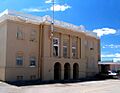
Rio Arriba County Courthouse, Isaac Rapp, 1916-17
|
|

Tierra Amarilla, New Mexico
Location in New Mexico

Tierra Amarilla, New Mexico
Location in the United States
|
|
| Country | United States |
| State | New Mexico |
| County | Rio Arriba |
| Area | |
| • Total | 2.69 sq mi (6.98 km2) |
| • Land | 2.69 sq mi (6.96 km2) |
| • Water | 0.01 sq mi (0.01 km2) |
| Elevation | 7,487 ft (2,282 m) |
| Population
(2020)
|
|
| • Total | 297 |
| • Density | 110.49/sq mi (42.65/km2) |
| Time zone | UTC−7 (MST) |
| • Summer (DST) | UTC−6 (MDT) |
| ZIP code |
87575
|
| Area code | 575 |
| FIPS code | 35-77670 |
| GNIS feature ID | 2584225 |
Tierra Amarilla is a small community in Rio Arriba County, New Mexico, United States. It is also the main town, or county seat, for Rio Arriba County.
The name Tierra Amarilla means "Yellow Earth" in Spanish. This name comes from the yellow clay found in the Chama River Valley. Native American people used this clay for a long time. Even the names for this area in the Tewa language and Navajo language talk about the yellow clay.
Contents
History of Tierra Amarilla
People have lived in the Chama River Valley for about 5,000 years. There are old pueblo sites south of Abiquiu. This area was an important trade route. It connected people from the Four Corners region to those in the Rio Grande Valley. Later, Navajo people used the valley as a place to prepare for raids on Spanish settlements.
In 1776, Spanish friars explored the Tierra Amarilla area. They wrote that it was a good place for farming and raising animals. The path they took from Santa Fe to California later became known as the Spanish Trail. During the Californian Gold Rush, the area became a stopping point for people heading west to find gold.
The Tierra Amarilla Land Grant
In 1832, the Mexican government created the Tierra Amarilla Land Grant. This was for Manuel Martinez and settlers from Abiquiu. This land grant covered a much larger area than the small community we know as Tierra Amarilla today.
The first settlers had trouble staying there permanently. This was because of raids by Ute, Navajo, and Jicarilla Apache tribes. They could not settle until the early 1860s.
In 1860, the United States Congress looked at the land grant. They decided it was a private grant, not a community grant. This was partly because some documents were mistranslated or hidden. Even though a full survey was needed, some of Manuel Martinez's family started selling parts of the land to new buyers.
In 1880, Thomas Catron sold some of the land to the Denver and Rio Grande Railway. This was for their train line and a service center in Chama. By 1883, Catron owned most of the grant, except for the original villages and their fields. In 1950, the descendants of the first grant holders tried to get their communal land back through the courts, but they were not successful.
Becoming the County Seat
In 1866, the United States Army set up Camp Plummer near Los Ojos. This was to help control Native American activity, which had already decreased. The camp was left empty in 1869.
The community we know today, Las Nutrias, was founded around 1862. The first post office in Las Nutrias opened in 1866. It was named Tierra Amarilla. The current post office, also named Tierra Amarilla, opened in 1870. In 1877, a U.S. Army lieutenant called the village "the center of the Mexican population of northwestern New Mexico."
In 1880, the government of New Mexico made Las Nutrias the county seat for Rio Arriba County. They also renamed the village Tierra Amarilla. The arrival of the Denver and Rio Grande Railway in Chama in 1881, about ten miles north, greatly changed the area. It helped connect the region to the outside world.
When Tierra Amarilla became the county seat, people built a courthouse. This first building was later taken down to make way for the current one. The new courthouse was built in 1917. It became famous fifty years later because of a gunfight between land rights activists and authorities. The building, designed by Isaac Rapp, is now on the National Register of Historic Places.
The Courthouse Raid
In 1967, a group called the Alianza Federal de Mercedes, led by Reies Tijerina, raided the Rio Arriba County Courthouse. They wanted to make a "citizen's arrest" of the district attorney. Their goal was to show how government and new settlers had unfairly taken land from Hispanic families.
During the event, a struggle happened inside the courthouse. Tijerina and his group left, taking two people as hostages. A prison guard was shot, and a sheriff's deputy was badly hurt. The National Guard, FBI, and New Mexico State Police chased Tijerina. He was later sentenced to less than three years in prison.
Geography and Landscape
Tierra Amarilla is located among a group of villages along U.S. Route 84 and the Chama River. The villages are not laid out in the traditional way that Spanish towns were planned.
The Brazos Cliffs are a well-known landmark and attraction nearby. Also close by are the human-made Heron Lake and El Vado Lake. Tierra Amarilla is high up, at about 7,524 feet (2,293 meters) above sea level.
Climate and Weather
Tierra Amarilla has a humid continental climate. This means it has very cold, snowy winters, but they are often sunny. Summers have very warm or hot afternoons, but the mornings are cool or cold.
In winter, mornings are very cold. The temperature can drop to 0°F (-18°C) or lower about 27 times in an average winter. The coldest temperature ever recorded was -39°F (-39°C) on January 6, 1971. Snowfall is much heavier here than in other parts of New Mexico. This is because Tierra Amarilla is on a western slope, not in a valley. The area gets about 62 inches (1.5 meters) of snow each year.
Spring is the sunniest time of year, and temperatures slowly get warmer. However, it can still freeze as late as June. Summer is the wettest season because of frequent thunderstorms.
| Climate data for Tierra Amarilla 4 N, New Mexico, 1991–2020 normals, 1927-2020 extremes: 7464ft (2275m) | |||||||||||||
|---|---|---|---|---|---|---|---|---|---|---|---|---|---|
| Month | Jan | Feb | Mar | Apr | May | Jun | Jul | Aug | Sep | Oct | Nov | Dec | Year |
| Record high °F (°C) | 60 (16) |
65 (18) |
74 (23) |
80 (27) |
91 (33) |
95 (35) |
102 (39) |
97 (36) |
90 (32) |
85 (29) |
72 (22) |
66 (19) |
102 (39) |
| Mean maximum °F (°C) | 54.1 (12.3) |
55.6 (13.1) |
64.0 (17.8) |
70.7 (21.5) |
80.5 (26.9) |
87.3 (30.7) |
91.3 (32.9) |
88.7 (31.5) |
82.7 (28.2) |
75.5 (24.2) |
63.5 (17.5) |
53.5 (11.9) |
90.2 (32.3) |
| Mean daily maximum °F (°C) | 40.2 (4.6) |
43.3 (6.3) |
51.2 (10.7) |
58.8 (14.9) |
68.1 (20.1) |
79.5 (26.4) |
83.3 (28.5) |
80.9 (27.2) |
73.9 (23.3) |
62.5 (16.9) |
50.4 (10.2) |
40.0 (4.4) |
61.0 (16.1) |
| Daily mean °F (°C) | 22.9 (−5.1) |
26.6 (−3.0) |
34.7 (1.5) |
41.5 (5.3) |
49.7 (9.8) |
58.9 (14.9) |
64.8 (18.2) |
63.2 (17.3) |
55.7 (13.2) |
44.7 (7.1) |
33.6 (0.9) |
23.9 (−4.5) |
43.4 (6.3) |
| Mean daily minimum °F (°C) | 5.7 (−14.6) |
9.8 (−12.3) |
18.2 (−7.7) |
24.2 (−4.3) |
31.3 (−0.4) |
38.3 (3.5) |
46.3 (7.9) |
45.5 (7.5) |
37.5 (3.1) |
26.8 (−2.9) |
16.8 (−8.4) |
7.8 (−13.4) |
25.7 (−3.5) |
| Mean minimum °F (°C) | −10.3 (−23.5) |
−8.0 (−22.2) |
1.9 (−16.7) |
12.4 (−10.9) |
21.8 (−5.7) |
28.8 (−1.8) |
37.7 (3.2) |
38.7 (3.7) |
25.9 (−3.4) |
14.3 (−9.8) |
0.5 (−17.5) |
−8.7 (−22.6) |
−13.9 (−25.5) |
| Record low °F (°C) | −39 (−39) |
−40 (−40) |
−16 (−27) |
−9 (−23) |
12 (−11) |
21 (−6) |
31 (−1) |
29 (−2) |
19 (−7) |
5 (−15) |
−19 (−28) |
−31 (−35) |
−40 (−40) |
| Average precipitation inches (mm) | 1.20 (30) |
1.32 (34) |
0.95 (24) |
1.15 (29) |
1.50 (38) |
0.69 (18) |
1.74 (44) |
2.19 (56) |
1.93 (49) |
1.37 (35) |
1.22 (31) |
1.31 (33) |
16.57 (421) |
| Average snowfall inches (cm) | 17.70 (45.0) |
15.30 (38.9) |
9.80 (24.9) |
6.60 (16.8) |
0.70 (1.8) |
0.00 (0.00) |
0.00 (0.00) |
0.00 (0.00) |
0.00 (0.00) |
1.60 (4.1) |
8.40 (21.3) |
15.00 (38.1) |
75.1 (190.9) |
| Source 1: NOAA | |||||||||||||
| Source 2: XMACIS2 (records & monthly max/mins) | |||||||||||||
Population and Education
| Historical population | |||
|---|---|---|---|
| Census | Pop. | %± | |
| 2020 | 297 | — | |
| U.S. Decennial Census | |||
In 2020, the population of Tierra Amarilla was 297 people. The area has the ZIP code 87575.
The community is part of the Chama Valley Independent Schools district. There are two schools in Tierra Amarilla:
- Tierra Amarilla Elementary School, which serves students from Pre-Kindergarten to 6th grade.
- Escalante Middle/High School, for students in 7th to 12th grade.
Famous People from Tierra Amarilla
- Walter K. Martinez: A lawyer and state lawmaker from New Mexico.
- Sabine Ulibarrí: An American poet.
Images for kids
-
Rio Arriba County Courthouse, built in 1917.
See also
 In Spanish: Tierra Amarilla (Nuevo México) para niños
