
Chama, New Mexico facts for kids
Quick facts for kids
Chama, New Mexico
|
|
|---|---|
|
Village
|
|
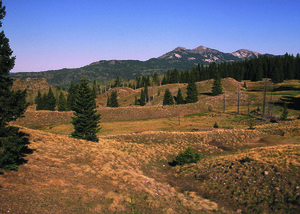
A ranch near Chama
|
|

Location of Chama in New Mexico
|
|

Chama, New Mexico
Location in the United States
|
|
| Country | United States |
| State | New Mexico |
| County | Rio Arriba |
| Area | |
| • Total | 2.91 sq mi (7.54 km2) |
| • Land | 2.88 sq mi (7.46 km2) |
| • Water | 0.03 sq mi (0.08 km2) |
| Elevation | 7,825 ft (2,385 m) |
| Population
(2020)
|
|
| • Total | 917 |
| • Density | 318.29/sq mi (122.91/km2) |
| Time zone | UTC-7 (Mountain (MST)) |
| • Summer (DST) | UTC-6 (MDT) |
| ZIP Code |
87520
|
| Area code(s) | 575 |
| FIPS code | 35-13970 |
| GNIS feature ID | 2413539 |
| Website | http://chamavillage.com/ |
Chama is a small village located in Rio Arriba County, New Mexico, in the United States. In 2020, about 917 people lived there. Chama is nestled in the Rocky Mountains, only about 7 miles (11 km) south of the border between Colorado and New Mexico.
Contents
Where is Chama Located?
Chama is right next to the Rio Chama river. It's about 6.5 miles (10.5 km) south of the Colorado state line. The village covers about 2.6 square miles (6.7 square kilometers) of land.
Chama's Past: A Railroad Town
Chama was once part of a large area called the Tierra Amarilla Land Grant. Its story really began in 1880. That's when the Denver & Rio Grande Railroad started building a new train line. This line, called the San Juan Extension, was heading west from Antonito, Colorado. It was going towards mining areas in Colorado.
Why Chama Was Important for Trains
The railroad needed a special place for extra train engines. These "helper locomotives" were needed to push trains up a very steep hill. This hill led towards Cumbres Pass. The railroad chose a spot on the west side of the Rio Chama river. This was where the tracks crossed the river. They built a train terminal and a town there. They named the village "Chama" after the river crossing.
Train service started on February 1, 1881. A post office was also set up that same year.
Timber and Sawmills
The northern valley of the Rio Chama had huge coniferous forests. These forests were full of tall Ponderosa pine trees. Because of this, cutting down trees and running sawmills became a big business. This industry grew quickly from the early 1880s and was very important until the 1930s.
The Cumbres and Toltec Scenic Railroad
Today, Chama is the western end of the Cumbres and Toltec Scenic Railroad. This is a special steam-powered, narrow gauge train. It's a "heritage railway" that takes visitors on scenic trips. You can ride it to and from Osier, Colorado, and Antonito, Colorado. These trips happen during the summer months.
This train line is 64 miles long. It's the part of the old Denver & Rio Grande's San Juan Extension that is still used. The tracks that went from Chama west to Durango, Colorado were closed in September 1967. They were taken up soon after.
Who Lives in Chama?
| Historical population | |||
|---|---|---|---|
| Census | Pop. | %± | |
| 1970 | 899 | — | |
| 1980 | 1,090 | 21.2% | |
| 1990 | 1,048 | −3.9% | |
| 2000 | 1,199 | 14.4% | |
| 2010 | 1,022 | −14.8% | |
| 2020 | 917 | −10.3% | |
| U.S. Decennial Census | |||
In 2000, about 1,199 people lived in Chama. There were 467 households, which are groups of people living together. About 312 of these were families.
Many different people make up Chama's population. In 2000, about 71% of the people were Hispanic or Latino.
Age and Income
About 26.6% of the people were under 18 years old. The average age in Chama was 38 years.
The average income for a household in Chama was about $30,513 per year. For families, the average income was about $31,983.
Learning in Chama
Chama is part of the Chama Valley Independent Schools district. The village has a school for younger students, called Chama Middle/Elementary School. This school teaches kids from kindergarten up to 8th grade. For high school, students from Chama usually go to Escalante Middle/High School. This is the only high school in the district.
Chama's Weather
Chama has a climate with big changes in temperature throughout the year. Summers are short and can be cool to warm. Winters are long and cold, sometimes very cold. This type of weather is known as a "warm-summer humid continental climate."
| Climate data for Chama, New Mexico (1991–2020 normals, extremes 1893–present) | |||||||||||||
|---|---|---|---|---|---|---|---|---|---|---|---|---|---|
| Month | Jan | Feb | Mar | Apr | May | Jun | Jul | Aug | Sep | Oct | Nov | Dec | Year |
| Record high °F (°C) | 69 (21) |
65 (18) |
77 (25) |
79 (26) |
89 (32) |
98 (37) |
99 (37) |
99 (37) |
94 (34) |
84 (29) |
79 (26) |
68 (20) |
99 (37) |
| Mean maximum °F (°C) | 50.3 (10.2) |
52.7 (11.5) |
62.3 (16.8) |
69.6 (20.9) |
77.6 (25.3) |
86.6 (30.3) |
88.5 (31.4) |
85.8 (29.9) |
81.7 (27.6) |
73.8 (23.2) |
62.4 (16.9) |
52.7 (11.5) |
89.5 (31.9) |
| Mean daily maximum °F (°C) | 37.5 (3.1) |
40.8 (4.9) |
48.4 (9.1) |
56.2 (13.4) |
65.5 (18.6) |
76.8 (24.9) |
80.4 (26.9) |
77.8 (25.4) |
71.5 (21.9) |
60.6 (15.9) |
47.7 (8.7) |
37.7 (3.2) |
58.4 (14.7) |
| Daily mean °F (°C) | 22.3 (−5.4) |
25.8 (−3.4) |
33.4 (0.8) |
40.2 (4.6) |
48.5 (9.2) |
57.6 (14.2) |
63.2 (17.3) |
61.7 (16.5) |
54.7 (12.6) |
43.9 (6.6) |
32.3 (0.2) |
22.9 (−5.1) |
42.2 (5.7) |
| Mean daily minimum °F (°C) | 7.1 (−13.8) |
10.8 (−11.8) |
18.3 (−7.6) |
24.2 (−4.3) |
31.5 (−0.3) |
38.5 (3.6) |
46.0 (7.8) |
45.6 (7.6) |
37.9 (3.3) |
27.1 (−2.7) |
16.9 (−8.4) |
8.2 (−13.2) |
26.0 (−3.3) |
| Mean minimum °F (°C) | −11.1 (−23.9) |
−8.2 (−22.3) |
−0.2 (−17.9) |
10.0 (−12.2) |
20.1 (−6.6) |
27.7 (−2.4) |
37.0 (2.8) |
37.7 (3.2) |
25.4 (−3.7) |
12.3 (−10.9) |
−1.6 (−18.7) |
−10.7 (−23.7) |
−15.2 (−26.2) |
| Record low °F (°C) | −30 (−34) |
−30 (−34) |
−19 (−28) |
−8 (−22) |
7 (−14) |
18 (−8) |
28 (−2) |
15 (−9) |
13 (−11) |
−2 (−19) |
−23 (−31) |
−30 (−34) |
−30 (−34) |
| Average precipitation inches (mm) | 2.04 (52) |
1.94 (49) |
1.45 (37) |
1.51 (38) |
1.59 (40) |
0.80 (20) |
2.32 (59) |
3.02 (77) |
2.32 (59) |
1.73 (44) |
1.69 (43) |
1.94 (49) |
22.35 (568) |
| Average snowfall inches (cm) | 22.6 (57) |
23.0 (58) |
13.9 (35) |
5.9 (15) |
1.1 (2.8) |
0.0 (0.0) |
0.0 (0.0) |
0.0 (0.0) |
0.0 (0.0) |
2.1 (5.3) |
9.7 (25) |
13.6 (35) |
91.9 (233) |
| Average extreme snow depth inches (cm) | 22.9 (58) |
26.3 (67) |
20.7 (53) |
5.0 (13) |
0.3 (0.76) |
0.0 (0.0) |
0.0 (0.0) |
0.0 (0.0) |
0.0 (0.0) |
1.6 (4.1) |
6.7 (17) |
13.9 (35) |
28.5 (72) |
| Average precipitation days (≥ 0.01 inch) | 7.2 | 8.4 | 6.7 | 7.1 | 7.6 | 4.8 | 12.3 | 12.9 | 9.0 | 7.0 | 5.5 | 7.9 | 96.4 |
| Average snowy days (≥ 0.1 in) | 6.7 | 7.4 | 4.3 | 2.5 | 0.5 | 0.0 | 0.0 | 0.0 | 0.0 | 0.7 | 3.5 | 6.3 | 31.9 |
| Source: NOAA | |||||||||||||
See also
 In Spanish: Chama (Nuevo México) para niños
