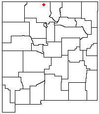
Brazos Mountains facts for kids
The Brazos Mountains are a mountain range in northern New Mexico, in the southwestern United States. They are found in Rio Arriba County. These mountains are part of the larger San Juan Mountains, which are mostly in Colorado.
The Brazos Mountains have a high ridge that stretches for over 20 miles (32 km). This ridge runs from the border with Colorado towards the southeast. The highest point in the range is on Grouse Mesa, reaching 11,405 feet (3,476 meters) high. This spot is called the Brazos Benchmark. Just a bit to the southeast, you'll find Brazos Peak, which is 11,288 feet (3,440 meters) tall.
Most of the Brazos Mountains are on private land called the Tierra Amarilla Land Grant. The Carson National Forest is located to the east and south of the range. These mountains offer a great view, especially from Heron Lake to the west.
U.S. Route 64 crosses the southern part of the Brazos Mountains. It goes over a pass that is 10,481 feet (3,194 meters) high. This is the highest paved road pass in New Mexico. Close by are the amazing Brazos Cliffs. These cliffs are where the Rio Brazos river begins. This river is part of the Rio Chama river system. The Chama River is the biggest river that flows into the Rio Grande. The Brazos Mountains are like the southern end of the South San Juan Range, which is in Colorado.
How the Brazos Mountains Formed
The Brazos Mountains are what's left of very old mountains. These mountains were formed between 80 and 55 million years ago. This happened during a time called the Laramide orogeny. Over millions of years, wind and water wore them down. This process created a flatter land surface called a peneplain.
The Sangre de Cristo Mountains are to the east and northeast of the Brazos Mountains. They were formed in a similar way. The Brazos Cliffs are a dramatic part of the landscape near Tierra Amarilla. These cliffs are made of a very strong rock called Precambrian quartzite. This rock is incredibly old, dating back to a time before complex life appeared on Earth.

Images for kids
See also
 In Spanish: Sierra de los Brazos para niños
 | Bayard Rustin |
 | Jeannette Carter |
 | Jeremiah A. Brown |


