Alamosa River facts for kids
Quick facts for kids Alamosa River |
|
|---|---|

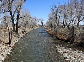
The river at Capulin.
|
|
| Country | United States |
| State | Colorado |
| Physical characteristics | |
| Main source | 37°21′44″N 106°37′12″W / 37.36222°N 106.62000°W |
| River mouth | Rio Grande arid land south of Alamosa 37°23′54″N 106°50′20″W / 37.39833°N 106.83889°W |
| Length | 64 mi (103 km), west-east |
| Basin features | |
| Basin size | 148 sq mi (380 km2) |
The Alamosa River is a river located in the southern part of the U.S. state of Colorado. It flows for about 64 miles (103 km) generally towards the east. The river runs through the San Luis Valley, a large, flat area in Colorado.
The area of land that drains into the Alamosa River, called its watershed, covers about 148 square miles (383 square kilometers). The river's name, "Alamosa," comes from the Spanish language. It means "shaded with cottonwood trees," which likely describes the trees found along its banks.
River Challenges and Protection
The Alamosa River has faced challenges in the past. It was affected by pollution from a nearby mine called the Summitville mine. This event caused significant harm to the river's water quality and the environment around it.
After the pollution incident, a lot of effort went into cleaning up the river. People worked hard to restore the river's health. This helped to bring back plants and animals that depend on the river. Protecting rivers like the Alamosa is important for nature and for people.
Where the River Flows
The Alamosa River starts in the mountains and flows eastward. It eventually joins a much larger river called the Rio Grande. The Rio Grande is one of the longest rivers in North America. The Alamosa River meets the Rio Grande in a dry area south of the town of Alamosa.
 | Dorothy Vaughan |
 | Charles Henry Turner |
 | Hildrus Poindexter |
 | Henry Cecil McBay |

