
Saguache, Colorado facts for kids
Quick facts for kids
Saguache, Colorado
|
|
|---|---|

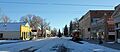
4th Street in downtown Saguache (2012)
|
|

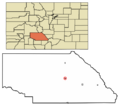
Location of Saguache in Saguache County, Colorado.
|
|
| Country | |
| State | |
| County | Saguache County – seat |
| Incorporated | August 13, 1891 |
| Government | |
| • Type | Statutory Town |
| Area | |
| • Total | 0.39 sq mi (1.02 km2) |
| • Land | 0.39 sq mi (1.02 km2) |
| • Water | 0.00 sq mi (0.00 km2) |
| Elevation | 7,704 ft (2,348 m) |
| Population
(2020)
|
|
| • Total | 539 |
| • Density | 1,382/sq mi (528.4/km2) |
| Time zone | UTC−7 (MST) |
| • Summer (DST) | UTC−6 (MDT) |
| ZIP code |
81149
|
| Area code(s) | 719 |
| FIPS code | 08-67005 |
| GNIS feature ID | 2412591 |
Saguache (pronounced sə-WAHTCH) is a small town in Colorado, United States. It is the main town, or county seat, of Saguache County. In 2020, about 539 people lived there.
Contents
A Look at Saguache's Past
Saguache is a historic town located in a farming area in southern Colorado. It sits at the northern entrance to the San Luis Valley. This valley is nestled between the Sangre de Cristo Range to the east and the San Juan Mountains to the west.
Saguache Creek flows through the town. This creek starts high up in the San Juan Mountains. Native American tribes knew this area for centuries. They would move from their summer homes in the mountains to the valley for winter.
Early Settlers and Growth
Spanish people began exploring this region in the 1600s. Spanish sheepherders used to pass through Saguache each year. They drove their sheep into the hills for summer grazing. Later, early white settlers and miners also traveled through this area. Many were looking for a path west along the Old Spanish Trail.
The first permanent white settlements in Saguache began in the mid-1860s. The nearby town of Villa Grove also started around this time. Saguache County was officially created in 1866.

The town's growth was shaped by the jobs and needs of the time. Saguache began as a trading post. In the late 1800s, mining became very important. The Colorado mining boom brought many mining operations to the mountains nearby. Miners needed a steady supply of food and other goods.
Otto Mears and the Town's Development
The town was founded by Otto Mears, who arrived in Saguache in 1867. Mears built a thresher and a grist mill. These machines helped farmers process wheat into flour. This flour then supplied Saguache and the surrounding mines.
Mears also built toll roads over nearby mountain passes. These roads were used to carry supplies to mining camps. They also helped open the area for more settlers. The Saguache Town Company was formed in 1874. This helped Saguache become a busy supply town. Mears even started a newspaper, the Saguache Chronicle. He hoped it would encourage more pioneers to come to Saguache. Mears later helped build the famous Million Dollar Highway.
Saguache Today

Saguache was once a booming town, but its population has become smaller. Today, about 500 people live there. A visitor guide for Saguache describes its past. It says that Saguache once had a hall for entertainment, a meat market, and a boarding house. There were also law firms, a hardware store, a hotel, and a sawmill. The Saguache Chronicle newspaper was also a big part of the town.
After a few name changes, the Saguache Chronicle became The Saguache Crescent. This newspaper is still printed every week. It uses a special flatbed press built in 1915. It also uses a Linotype composing machine. This Linotype machine might be the only one still used in the United States! The newspaper is still the county's official "paper of record." It is run by a family member who is the third generation to own it since 1917.
In the past, sheep ranching was common. Now, the area mostly raises cattle and grows alfalfa hay. Today, Saguache has one school, a library, and a museum. It also has four churches, two gas stations, and two grocery stores. There are two restaurants, a sawmill, and an organic farm.
What's in a Name?
The name Saguache has an interesting history. It is pronounced sə-WAHTCH.
Different Meanings of Saguache
According to a 2013 newspaper article, the name Saguache comes from a Ute language word. It means "sand dune." A Native American named Naranjo explained that the Utes did not have an alphabet. So, immigrants spelled the word the way they heard it. The original word was "sə wŭp," meaning "sand dunes." But people couldn't pronounce it easily, so they called it "sə wäch."
However, a 1995 letter to a magazine offered a different meaning. It said Saguache means "Blue earth — water at the blue earth." The writer believed the word came from a shorter form of the Ute word "Saguaguachipa." This word referred to springs where blue earth was found to the north.
The editors of the magazine replied that a Ute Dictionary from 1977 defined "sagwa-ci" as "Saguache," meaning "green place." One source also says the "blue earth" refers to a deposit of blue clay near the creek.
The Colorado State Historical Society has another idea. A monument in the community states that Saguache's name comes from the Indian word "Blue Water."
The Spanish language version of this name is usually spelled "Saguache." The English language version is often spelled "Sawatch."
Where Saguache Is Located
Saguache is served by U.S. Route 285 and Colorado State Highway 114. Saguache Creek flows to the southwest of the town.
The United States Census Bureau says the town covers about 0.4 square miles (1.02 square kilometers). All of this area is land.
Climate in Saguache
Saguache experiences a climate with warm summers and cold winters. Here is a summary of the average temperatures and precipitation:
| Climate data for Saguache, Colorado (1981–2010) | |||||||||||||
|---|---|---|---|---|---|---|---|---|---|---|---|---|---|
| Month | Jan | Feb | Mar | Apr | May | Jun | Jul | Aug | Sep | Oct | Nov | Dec | Year |
| Mean daily maximum °F (°C) | 35.4 (1.9) |
39.9 (4.4) |
49.8 (9.9) |
58.8 (14.9) |
67.1 (19.5) |
76.1 (24.5) |
79.9 (26.6) |
77.2 (25.1) |
71.4 (21.9) |
61.1 (16.2) |
47.2 (8.4) |
35.8 (2.1) |
58.3 (14.6) |
| Mean daily minimum °F (°C) | 5.4 (−14.8) |
10.7 (−11.8) |
20.5 (−6.4) |
26.8 (−2.9) |
35.3 (1.8) |
43.1 (6.2) |
49.0 (9.4) |
48.0 (8.9) |
39.5 (4.2) |
29.4 (−1.4) |
17.9 (−7.8) |
6.9 (−13.9) |
27.7 (−2.4) |
| Average precipitation inches (mm) | 0.23 (5.8) |
0.21 (5.3) |
0.39 (9.9) |
0.56 (14) |
0.62 (16) |
0.59 (15) |
1.29 (33) |
1.81 (46) |
1.09 (28) |
0.65 (17) |
0.35 (8.9) |
0.26 (6.6) |
8.05 (204) |
| Average snowfall inches (cm) | 3.5 (8.9) |
3.7 (9.4) |
3.9 (9.9) |
1.8 (4.6) |
0.5 (1.3) |
0.0 (0.0) |
0.0 (0.0) |
0.0 (0.0) |
0.0 (0.0) |
0.7 (1.8) |
2.5 (6.4) |
3.6 (9.1) |
20.3 (52) |
| Source: NOAA | |||||||||||||
Population Changes Over Time
The number of people living in Saguache has changed throughout history. Here's how the population has grown and shrunk over the years:
| Historical population | |||
|---|---|---|---|
| Census | Pop. | %± | |
| 1880 | 325 | — | |
| 1890 | 660 | 103.1% | |
| 1900 | 389 | −41.1% | |
| 1910 | 620 | 59.4% | |
| 1920 | 948 | 52.9% | |
| 1930 | 1,010 | 6.5% | |
| 1940 | 1,219 | 20.7% | |
| 1950 | 1,024 | −16.0% | |
| 1960 | 722 | −29.5% | |
| 1970 | 642 | −11.1% | |
| 1980 | 656 | 2.2% | |
| 1990 | 584 | −11.0% | |
| 2000 | 578 | −1.0% | |
| 2010 | 485 | −16.1% | |
| 2020 | 539 | 11.1% | |
Fun Things to Do in Saguache
Saguache is known as the gateway to the San Juan Mountains. This area includes the Rio Grande National Forest and the La Garita Wilderness Area. Because of this, Saguache offers many outdoor activities. You can enjoy sightseeing, cycling, hiking, and camping. Highway 114, which leads to Cochetopa Pass, follows part of the original Old Spanish Trail. This route offers beautiful mountain views and access to large areas of public land.

The Saguache Museum
Saguache has a small museum that tells the story of the area. The museum is proud of its exhibits. It has received praise from visitors from all over the United States and many other countries.
The museum also shares information about a famous local story involving a man named Alferd Packer. In 1874, Alferd Packer and five other men went looking for gold. They got stuck in a snowstorm near Lake City. Packer was the only one who came out of the mountains alive. He told different stories about what happened to the others. People found his stories suspicious, so he was held in the Saguache County Jail.
Packer escaped from jail in August. On the same day, the bodies of the missing men were found. Evidence suggested that something terrible had happened. Packer was later found and brought back to Lake City for trial. He was found guilty and spent 17 years in prison. He passed away in 1907. For the rest of his life, he was known as a good citizen.
This event was very shocking and widely reported at the time. It is still a well-known story in Colorado. The area where the bodies were found is now called Cannibal Plateau. In Lake City, people remember Alferd Packer with an annual Jeep Tour and Barbecue. There's even a cafeteria at the University of Colorado, Boulder, called the Alferd Packer Memorial Grill.
The Saguache museum has a display showing a figure of Packer in a cell. A sheriff figure guards him from his office chair. You can also see handcuffs, leg irons, and other items related to Alferd Packer's story.
Images for kids
-
4th Street in downtown Saguache (2012)
-
Location of Saguache in Saguache County, Colorado.
See also
 In Spanish: Saguache para niños
