Chama, Colorado facts for kids
Quick facts for kids
Chama, Colorado
|
|
|---|---|

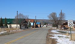
County Road L.7 in Chama.
|
|
| Country | |
| State | |
| Counties | Costilla County |
| Established | 1860 |
| Elevation | 8,186 ft (2,495 m) |
| Population | |
| • Total | 63 |
| Time zone | UTC-7 (MST) |
| • Summer (DST) | UTC-6 (MDT) |
| ZIP Code |
81126
|
| Area code(s) | (719) |
| GNIS feature | 203659 |
Chama is a small, quiet community in Costilla County, Colorado, United States. It's called an unincorporated community because it doesn't have its own city government. However, it does have its own U.S. Post Office.
Exploring Chama's Past
Chama is located in the beautiful Rio Culebra valley. This area was once part of a very large piece of land called the Sangre de Cristo Land Grant. This grant was given to the family of Carlos Beaubien in 1843 by the government of New Mexico.
The community of Chama was started in 1860. The first settlers came from a place called Chamita, which is in New Mexico. The Chama Post Office officially opened its doors on May 3, 1907. The local school building in Chama was taken down between 1999 and 2001.
What Chama Looks Like
Most of the houses in Chama are made from adobe. Adobe is a natural building material made from earth and organic materials. Many of these homes are very old, showing the long history of the community.
You'll also see many rocks around Chama. The area is home to "chamiso" sagebrush, a type of plant common in dry regions. The community sits right at the base of the Culebra Ranch, which adds to its scenic views.
 | Charles R. Drew |
 | Benjamin Banneker |
 | Jane C. Wright |
 | Roger Arliner Young |


