
Weston, Colorado facts for kids
Quick facts for kids
Weston, Colorado
|
|
|---|---|

Weston Supply and U.S. Post Office in Weston.
|
|

Location of the Weston CDP in Las Animas County, Colorado.
|
|

Weston, Colorado
Location in the United States
|
|
| Country | |
| State | |
| County | Las Animas County |
| Government | |
| • Type | unincorporated town |
| Area | |
| • Total | 3.099 sq mi (8.026 km2) |
| • Land | 3.099 sq mi (8.026 km2) |
| • Water | 0 sq mi (0.000 km2) |
| Elevation | 7,067 ft (2,154 m) |
| Population
(2020)
|
|
| • Total | 53 |
| • Density | 17.10/sq mi (6.60/km2) |
| Time zone | UTC-7 (MST) |
| • Summer (DST) | UTC-6 (MDT) |
| ZIP Code |
81091
|
| Area code(s) | 719 |
| GNIS feature ID | 2583316 |
Weston is a small, unincorporated town in Las Animas County, Colorado, United States. This means it's a community that isn't officially part of a city or town government. It also has its own post office and is recognized as a "census-designated place" (CDP) by the government for counting people. In 2020, only 53 people lived in Weston.
Contents
Weston's Past: A Look at Its History
The Weston Post Office has been open since 1889. The town was named after A. J. Weston, who was an early settler in the area.
There is an old church located at a place called Vigil Plaza, which is close to Weston.
Another old church and a cemetery can be found about three miles east of Weston, at Medina Plaza. This church was built around 1866 or 1867. In 2019, both the church and cemetery were added to the National Register of Historic Places. They are known as Our Lady of Guadalupe Church and Medina Cemetery.
Weston's Location: Where is it?
Weston is in the valley of the Purgatoire River. It sits on the north side of the river, close to where the South Fork joins the main river.
Colorado State Highway 12 goes through Weston. If you drive east on this highway, it's about 22 miles to Trinidad, which is the main town for the county. If you drive west, it's about 11 miles to Stonewall Gap.
The area officially known as the Weston CDP covers about 8.026 square kilometers (or about 1,983 acres) of land. There is no water area within this boundary.
Who Lives in Weston? Population Facts
The United States Census Bureau first officially defined Weston as a census-designated place for the United States Census 2010. This means they started counting its population separately then.
Here's how the population has changed:
| Weston CDP, Colorado | ||
|---|---|---|
| Year | Pop. | ±% |
| 2010 | 55 | — |
| 2020 | 53 | −3.6% |
| Source: United States Census Bureau | ||
Images for kids
-
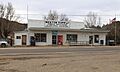
Weston Supply and U.S. Post Office in Weston.
-
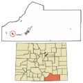
Location of the Weston CDP in Las Animas County, Colorado.
See also
 In Spanish: Weston (Colorado) para niños
