
Comanche National Grassland facts for kids
Quick facts for kids Comanche National Grassland |
|
|---|---|

Picketwire Canyon is typical of the canyons in the Comanche National Grassland.
|
|

Comanche National Grassland
Location in Colorado

Comanche National Grassland
Location in the United States
|
|
| Location | Baca, Otero, and Las Animas counties, Colorado, USA |
| Nearest city | La Junta, CO |
| Area | 443,081 acres (1,793.09 km2) |
| Established | June 23, 1960 |
| Governing body | U.S. Forest Service |
| Website | Comanche National Grassland |

The Comanche National Grassland is a special protected area in southeastern Colorado, United States. It is a huge area of open prairie and deep canyons. This grassland is like a sister to the Cimarron National Grassland.
It is split into two main parts. Each part has its own ranger district. One is in Springfield and the other is in La Junta. The U.S. Forest Service manages the grassland. They also manage the Pike and San Isabel National Forests. All these areas are managed from a main office in Pueblo, Colorado.
Contents
Geography of the Grassland
The Comanche National Grassland covers about 463,373 acres. That's a lot of land! It has two main sections. These are called the Timpas Unit and the Carrizo Unit. The Timpas Unit is south of La Junta. The Carrizo Unit is south of Springfield. Some private ranch land is mixed in with the government land in both units.
Land and Weather
The land here changes a lot. The lowest parts are about 3,900 feet high. This is in the Carrizo Unit near the Oklahoma border. The highest parts are about 6,200 feet high. This is on Fallas Mesa in the same unit.
The weather here can be extreme. It gets about 12 to 17 inches of rain each year. Summers are very hot, with temperatures often above 90°F. Winters are cold, with January temperatures usually below 20°F.
Plants and Animals
Most of the grassland is covered in short grasses. These are typical of steppe and shortgrass prairie areas. But you can also find different trees. Pinyon and juniper trees grow in rocky canyons. Cottonwoods and willows grow near streams.
Other plants include Western soapberry and netleaf hackberry. You might also see Gambel oak and Chickasaw plum. Sometimes, ponderosa pine trees grow on cool hillsides.
Many animals call this grassland home. You might spot pronghorn and mule deer. There are also prairie dogs and lesser prairie chickens. Other animals include wild turkeys and golden eagles. Look out for swift foxes and even roadrunners. Over 300 types of birds have been seen here.
Rivers and Creeks
Most of the Carrizo Unit's water flows into Carrizo Creek. This creek eventually joins the Cimarron River. The Timpas Unit's water flows into the Purgatoire River. This river is also known as the Purgatory or Picketwire River.
History of the Grassland
The Comanche National Grassland has a long and interesting history. People have lived here for thousands of years.
Ancient Inhabitants
You can find signs of ancient American Indians here. Look for petroglyphs on rocks and cliffs in the canyons. Some of this rock art is 8,000 years old! Some drawings are newer and show horses. Horses arrived in the Southwest with the Spanish in the 1500s.
Early Native Americans lived in rock shelters found in the grassland. They hunted animals and gathered plants for food. Around 1000 AD, a group called the Apishipa tried farming here. Later, the Apache people lived in this area. The Comanche pushed them south in the 1700s. You can still see tipi rings. These are circles of stones that held down the edges of tipis.
Trails and Settlers
A part of the famous Santa Fe Trail crossed the Timpas unit. From the 1820s, wagons full of goods traveled this trail. They went from Missouri and Kansas to New Mexico.
The first non-Native American settlers arrived in 1871. Eleven families from New Mexico settled along the Purgatory River. That same year, Eugene and Mary Rourke started a ranch nearby. More settlers came and grew crops like broomcorn.
The Dust Bowl and Creation of the Grassland
In the 1930s, the "Dust Bowl" hit this area hard. Farmers could not grow crops because of severe droughts and dust storms. Many lost their farms. The government bought this land from the farmers who went bankrupt. The Comanche National Grassland was officially created in 1960. Today, ranchers can get permits from the Forest Service to graze cattle on most of the grassland.
Land Changes and Protection
In 1991, the U.S. Army gave 16,000 acres of land to the National Grassland. This land was in the Purgatoire River Canyon. It was part of the Piñon Canyon Maneuver Site (PCMS). This site is used for military training.
Later, the Army wanted to expand the PCMS. They planned to buy more land, including parts of the Comanche National Grassland. Many local people and politicians did not agree with this plan. They protested, and in 2013, the Army stopped the expansion plan. This was good news for the grassland and the people living nearby.
Fun Things to Do in the Timpas Unit

Picketwire Canyon
Picketwire Canyon is about 400 feet deep. It has the Purgatoire River track site. This is one of the biggest dinosaur track sites in the world! You can see over 1,300 tracks from dinosaurs like Brontosaurs and Allosaurs. These tracks are 150 million years old!
You can explore the canyon by hiking, biking, or horseback riding. The trail is 8.7 miles long (one way). It leads to the Dolores Mission, which are old church ruins. You can also see the dinosaur tracks and the Rourke Ranch. The Rourke Ranch was a working ranch from 1871 to 1971. It is now a National Historic Site.
Usually, cars are not allowed on the trail. But on weekends, rangers lead tours in special vehicles. You need to bring your own vehicle for these tours.

Vogel Canyon
Vogel Canyon is a smaller canyon near the Purgatory River. It has a nice picnic area. There are also eight miles of easy trails. You can walk along the top of the mesa or go into the canyon. The canyon has springs, old ruins, and cool rock art.
Santa Fe Trail Historic Sites
You can visit parts of the historic Santa Fe Trail here. Check out the Sierra Vista Overlook, Timpas Picnic Area, and Iron Springs. The Sierra Vista Overlook gives you amazing views of the Rocky Mountains, about 75 miles away!
Stone posts mark the Santa Fe Trail. You can walk along it for three miles between Sierra Vista and Timpas Picnic area. There's also a short nature trail (half a mile) to Timpas Creek. This creek was an important watering spot along the old Santa Fe Trail.
Fun Things to Do in the Carrizo Unit
Picture Canyon
Picture Canyon is just north of the Oklahoma border. It got its name from the ancient rock art found there. It's a small canyon with gentle slopes. It has big springs, picnic tables, and a hiking trail that is 2.6 miles long.
You can take a longer hike (six miles round-trip) by going west from the parking area into Nort (or Holt) Canyon. On the west side of Picture Canyon is Crack Cave. Its walls are full of rock art! One special group of drawings in the cave lights up with sunlight for only about ten minutes. This happens at sunrise during the Spring and Autumn equinoxes. The cave is usually locked. But during the equinoxes, tours are offered to see the glowing petroglyphs.
Carrizo Canyon
Carrizo Canyon is a well-watered canyon. It also has rock art, picnic tables, and a hiking trail. You can even go fishing for Channel Catfish in Carrizo Creek.
Cottonwood Canyon
Cottonwood Canyon is one of the best places in Colorado for birdwatching. There's a campground at the entrance (on private land). The canyon is five miles long and has a road running through it.
Campo Lek
The Campo Lek is a special place to see lesser prairie chickens. A "lek" is where these birds gather to perform their mating dances. This is the only public lek in Colorado. Sometimes, it is closed to visitors. This happens when the prairie chicken population is very low.
Camping and Hunting
You can do primitive camping on most of the Comanche National Grassland. But it is not allowed in Picketwire Canyon. Hunting is also permitted for animals like mule deer, elk, pronghorn, wild turkey, and small game. You must follow Colorado state hunting rules.
Gallery
-
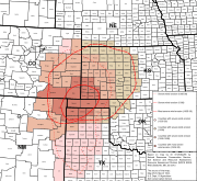
Map of states and counties affected by the Dust Bowl between 1935 and 1938 originally prepared by the Soil Conservation Service. The most severely affected counties are colored .
.svg)
