Trinchera, Colorado facts for kids
Quick facts for kids
Trinchera, Colorado
|
|
|---|---|

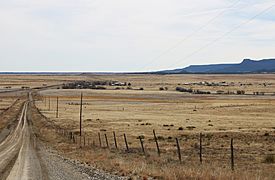
Trinchera viewed from a hill just west of town
|
|
| Country | |
| State | |
| County | Las Animas County |
| Elevation | 1,765 m (5,791 ft) |
| Time zone | UTC-7 (MST) |
| • Summer (DST) | UTC-6 (MDT) |
| ZIP code |
81081
|
| Area code(s) | 719 |
| GNIS feature ID | 0204814 |
Trinchera is a small place in Las Animas County, Colorado, United States. It is known as an unincorporated community. This means it does not have its own local government like a city or town.
Trinchera also has a U.S. Post Office. The special mail code, called a ZIP Code, for Trinchera is 81081. The post office first opened way back in 1889. The name "Trinchera" comes from the Spanish language. It means "trench" or "ditch."
Where is Trinchera?
Trinchera is located in the state of Colorado. You can find it on a map using its special coordinates. These are 37.042847 degrees North and 104.047565 degrees West.
Black History Month on Kiddle
African-American Artists you should know:
 | John T. Biggers |
 | Thomas Blackshear |
 | Mark Bradford |
 | Beverly Buchanan |

All content from Kiddle encyclopedia articles (including the article images and facts) can be freely used under Attribution-ShareAlike license, unless stated otherwise. Cite this article:
Trinchera, Colorado Facts for Kids. Kiddle Encyclopedia.


