
Model, Colorado facts for kids
Quick facts for kids
Model, Colorado
|
|
|---|---|

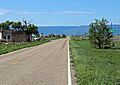
Looking south along U.S. Route 350 in Model
|
|

Model, Colorado
Location in Colorado

Model, Colorado
Location in the United States
|
|
| Country | |
| State | |
| County | Las Animas |
| Elevation | 5,617 ft (1,712 m) |
| Time zone | UTC-7 (MST) |
| • Summer (DST) | UTC-6 (MDT) |
| ZIP code |
81059
|
| Area code(s) | 719 |
| GNIS feature ID | 0204809 |
Model is a quiet, mostly abandoned place in Las Animas County, Colorado, United States. It used to be a small village that was not officially part of a city or town. This type of place is called an unincorporated community.
The name "Model" comes from the fact that it was originally a "model" or planned settlement. This means it was carefully designed before people moved there. Its post office, which opened in 1912, was the last business there until it closed in 2021.
Where is Model, Colorado Located?
Model is found in the state of Colorado. It is located at these coordinates: 37°22′22″N 104°14′43″W / 37.37278°N 104.24528°W. This means it is 37 degrees, 22 minutes, 22 seconds North and 104 degrees, 14 minutes, 43 seconds West.
It sits at an elevation of about 1,712 meters (5,617 feet) above sea level. This is quite high up, as Colorado is known for its mountains and high plains.
What is a ZIP Code?
A ZIP Code is a special set of numbers used by the United States Postal Service to help sort mail. Each ZIP Code points to a specific area. Model, Colorado, had its own ZIP Code, which was 81059. This code helped mail get to the people living there.
Images for kids
-
Looking south along U.S. Route 350 in Model
