Mesa de Maya facts for kids
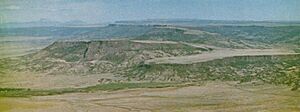
The Mesa de Maya is a large, flat-topped mountain, also called a tableland, that stands tall above the Great Plains in southeastern Colorado. It rises from 500 feet (150 m) to 1,200 feet (370 m) higher than the land around it. A part of this mesa, known as Black Mesa, stretches into northeastern New Mexico and a bit into Oklahoma.
The Mesa de Maya's height changes from 4,800 feet (1,500 m) on its eastern side to 6,902 feet (2,104 m) in the west. This area, along with other high, flat-topped mountains near Raton, New Mexico and Trinidad, Colorado, is sometimes called the Raton Mesa region. All these mesas were formed by ancient lava flows that cooled and hardened into a tough rock called basalt. Over millions of years, the softer rocks around the basalt wore away, leaving these distinct, high tablelands with steep sides, like the Mesa de Maya.
Contents
What is the Mesa de Maya?

The Mesa de Maya was created about 180 million years ago from a huge flow of basalt lava. This lava started flowing from a place called Piney Mountain in Colorado. The original lava flow was about 55 miles long. It was between one-half mile (1 km) and 8 miles (13 km) wide, and about 600 feet (180 m) thick. Today, the parts of this lava flow that haven't worn away are what we call the Mesa de Maya and Black Mesa.
The western end of the Mesa de Maya is about 11 miles northeast of Branson, Colorado. The mesa has two main parts. The biggest part is about 24 miles long and six miles wide. It slopes down from 6,902 feet (2,104 m) in the west to 5,600 feet (1,700 m) in the east.
Plants and Animals of the Mesa
The top of the Mesa de Maya is mostly covered in grassland, like shortgrass prairie. The slopes leading up to the mesa are usually covered in trees. You'll find many juniper and pinyon pine trees here. In places that are cooler and wetter, there are also some ponderosa pines and quaking aspen trees. The Mesa de Maya is special because it's the only place in Colorado where you can find mesquite plants. A stream called North Carrizo Creek also starts on the Mesa de Maya.
From the main part of the Mesa de Maya, a long, narrow section extends southeast. This part is about one mile wide and is called Black Mesa. It stretches for another 25 miles (40 km) into New Mexico and Oklahoma. It runs between North Carrizo Creek and the Cimarron River. The highest point of Black Mesa in New Mexico is 5,266 feet (1,605 m), and in Oklahoma, it's 4,973 feet (1,516 m).
Many different animals live on and around the Mesa de Maya. Some ranchers allow people to hunt large elk on their land. You can also find Mule deer, black bear, cougar, bighorn sheep, pronghorn, and golden eagles here. Some ranchers also let bird watchers and nature lovers visit their land for a fee.
Life Around the Mesa
Only one public dirt road crosses the Mesa de Maya in the middle. There are no big towns or cities nearby. Just a few ranch families live close to the mesa. The closest small towns are Kim, Colorado and Kenton, Oklahoma. These towns get about 16.7 inches (420 mm) of rain each year, mostly during the summer months. The mesa likely gets a similar amount of rain.
Piñon Canyon Maneuver Site
In 2003, the Army suggested making the Piñon Canyon Maneuver Site (PCMS) much larger. They wanted to add about 6.9 million acres (27,923 km2) of land. This land was owned by private citizens and the Comanche National Grassland in southeastern Colorado. The plan would have included the Mesa de Maya in Colorado. It would have made PCMS three times bigger than any other military base in the United States.
Two groups of citizens were formed to stop this expansion: The Pinyon Canyon Expansion Opposition Coalition and Not 1 More Acre. They called the plan "one colossal land grab." Ranchers and local people started these groups because they wanted to protect their private property and the traditional ranching way of life in southeastern Colorado. In 2013, the plan to expand PCMS was canceled.
 | Laphonza Butler |
 | Daisy Bates |
 | Elizabeth Piper Ensley |

