Bent County, Colorado facts for kids
Quick facts for kids
Bent County
|
|
|---|---|

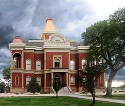
Bent County Courthouse in Las Animas
|
|

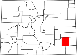
Location within the U.S. state of Colorado
|
|
 Colorado's location within the U.S. |
|
| Country | |
| State | |
| Founded | February 6, 1874 |
| Named for | William Bent |
| Seat | Las Animas |
| Largest city | Las Animas |
| Area | |
| • Total | 1,541 sq mi (3,990 km2) |
| • Land | 1,513 sq mi (3,920 km2) |
| • Water | 28 sq mi (70 km2) 1.8%% |
| Population
(2020)
|
|
| • Total | 5,650 |
| • Density | 3.7/sq mi (1.4/km2) |
| Time zone | UTC−7 (Mountain) |
| • Summer (DST) | UTC−6 (MDT) |
| Congressional district | 4th |
Bent County is a place in the state of Colorado, USA. In 2020, about 5,650 people lived there. The main town, or "county seat," is Las Animas. It is the only official town in the county. The county got its name from a famous trader named William Bent.
Contents
History of Bent County
After the American Civil War, many people moved to Colorado. Because of this, the government needed to be closer to where people lived. This helped with business and making sure laws were followed.
Bent County was first created in February 1870. A few years later, in February 1874, another county called Greenwood County was split up. Parts of it became part of Bent County. At that time, Bent County was very large and covered a big part of southeastern Colorado.
In 1889, Bent County became the size it is today. This happened when parts of it were used to create five new counties. These new counties were Cheyenne, Lincoln, Kiowa, Otero, and Prowers counties.
Geography of Bent County
Bent County covers about 1,541 square miles. Most of this area, about 1,513 square miles, is land. The rest, about 28 square miles, is water.
Neighboring Counties
Bent County shares its borders with several other counties:
- Kiowa County is to the north.
- Prowers County is to the east.
- Baca County is to the southeast.
- Las Animas County is to the southwest.
- Otero County is to the west.
Main Roads
Several important roads pass through Bent County:
 U.S. Highway 50
 State Highway 101
 State Highway 109
 State Highway 194
 State Highway 196
Protected Areas and Trails
- John Martin Reservoir State Park is a state park located in Bent County.
- The American Discovery Trail passes through the county.
- The Santa Fe National Historic Trail is a historic route here.
- The Santa Fe Trail National Scenic Byway is a special scenic road.
People in Bent County
| Historical population | |||
|---|---|---|---|
| Census | Pop. | %± | |
| 1870 | 592 | — | |
| 1880 | 1,654 | 179.4% | |
| 1890 | 1,313 | −20.6% | |
| 1900 | 3,049 | 132.2% | |
| 1910 | 5,043 | 65.4% | |
| 1920 | 9,705 | 92.4% | |
| 1930 | 9,134 | −5.9% | |
| 1940 | 9,653 | 5.7% | |
| 1950 | 8,775 | −9.1% | |
| 1960 | 7,419 | −15.5% | |
| 1970 | 6,493 | −12.5% | |
| 1980 | 5,945 | −8.4% | |
| 1990 | 5,048 | −15.1% | |
| 2000 | 5,998 | 18.8% | |
| 2010 | 6,499 | 8.4% | |
| 2020 | 5,650 | −13.1% | |
| 2023 (est.) | 5,681 | −12.6% | |
| U.S. Decennial Census 1790-1960 1900-1990 1990-2000 2010-2020 |
|||
In 2000, there were about 5,998 people living in Bent County. The population density was about 4 people per square mile.
About 23.8% of the people were under 18 years old. The average age of people in the county was 37 years. For every 100 females, there were about 129 males.
Towns and Places
Bent County has one main city and several smaller communities.
Cities
Unincorporated Places
These are smaller communities that are not officially incorporated as cities or towns:
Images for kids
See also
 In Spanish: Condado de Bent para niños
 | John T. Biggers |
 | Thomas Blackshear |
 | Mark Bradford |
 | Beverly Buchanan |


