Starkville, Colorado facts for kids
Quick facts for kids
Starkville, Colorado
|
|
|---|---|

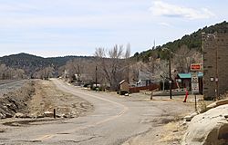
East Railroad Avenue (shown) serves as Starkville's main street.
|
|

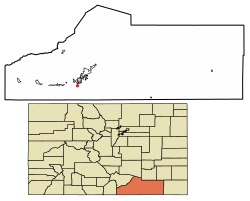
Location of Starkville in Las Animas County, Colorado.
|
|
| Country | |
| State | |
| County | Las Animas |
| Incorporated | March 2, 1954 |
| Named for | Albert G. Stark |
| Government | |
| • Type | Statutory Town |
| Area | |
| • Total | 0.07 sq mi (0.19 km2) |
| • Land | 0.07 sq mi (0.19 km2) |
| • Water | 0.00 sq mi (0.00 km2) |
| Elevation | 6,355 ft (1,937 m) |
| Population
(2020)
|
|
| • Total | 62 |
| • Density | 739.73/sq mi (285.69/km2) |
| Time zone | UTC-7 (Mountain (MST)) |
| • Summer (DST) | UTC-6 (MDT) |
| ZIP code |
81082
|
| Area code(s) | 719 |
| FIPS code | 08-73715 |
| GNIS feature ID | 2413331 |
Starkville is a small town in Las Animas County, Colorado, United States. It is known as a "statutory town," which means it follows general laws set by the state of Colorado for how towns should be run. In 2020, the town had a population of 62 people.
Contents
History of Starkville
The town of Starkville was named after Albert G. Stark. He was a person who owned a coal mine in the area.
Starkville used to be a company town. This means that a single company, the Colorado Fuel and Iron Company, owned and operated most of the town. It was mainly a place where people lived and worked in the coal mines. On October 8, 1910, an explosion occurred at the Starkville mine, affecting 56 miners. One month later, on November 8, 1910, another explosion happened at a nearby mine in Delagua, Colorado. This event affected 76 miners. Miners from Starkville helped with the rescue efforts after this second accident.
Starkville's Location and Area
Starkville is a very small town. It covers an area of about 0.1 square miles (0.19 square kilometers), and all of it is land. The town is located about 4 miles (6.4 km) south of Trinidad, Colorado. It is also about 8 miles (12.9 km) from the border of New Mexico, near Raton Pass.
A long time ago, in the 1800s, the famous Santa Fe Trail passed right through the community. Today, Starkville is very close to Interstate 25, a major highway. It is also next to the Atchison, Topeka and Santa Fe Railroad tracks.
Population Information
The population of Starkville has changed a lot over the years. Here's a quick look at how many people have lived there during different census counts:
| Historical population | |||
|---|---|---|---|
| Census | Pop. | %± | |
| 1890 | 928 | — | |
| 1960 | 261 | — | |
| 1970 | 166 | −36.4% | |
| 1980 | 127 | −23.5% | |
| 1990 | 104 | −18.1% | |
| 2000 | 128 | 23.1% | |
| 2010 | 59 | −53.9% | |
| 2020 | 62 | 5.1% | |
| U.S. Decennial Census | |||
What the Numbers Show
In 2010, there were 59 people living in Starkville. These people lived in 26 different homes. About 23% of the homes had children under 18 living there. Many of the people living in Starkville were of Hispanic or Latino background, making up about 73% of the population. The average age of people in Starkville in 2010 was around 44.5 years old.
See also
 In Spanish: Starkville (Colorado) para niños
 | Selma Burke |
 | Pauline Powell Burns |
 | Frederick J. Brown |
 | Robert Blackburn |

