Tyrone, Colorado facts for kids
Quick facts for kids
Tyrone, Colorado
|
|
|---|---|

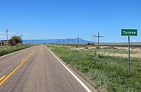
Tyrone, looking southwest along U.S. Route 350, with Raton Mesa in the distance
|
|
| Country | |
| State | |
| County | Las Animas County |
| Elevation | 5,541 ft (1,689 m) |
| Time zone | UTC-7 (MST) |
| • Summer (DST) | UTC-6 (MDT) |
| ZIP code |
81059 (Model)
|
| Area code(s) | 719 |
| GNIS feature ID | 0204807 |
Tyrone is a small place in Colorado, United States. It's known as an unincorporated community, which means it doesn't have its own local government like a city or town. Tyrone is located in Las Animas County. Even though it's a community, mail for Tyrone goes through the U.S. Post Office in a nearby town called Model, using ZIP Code 81059.
About Tyrone, Colorado
Tyrone used to have its own post office! It first opened in 1929 and stayed open for many years until 1968. It's a bit of a mystery how Tyrone got its name, as its origin is not well known.
Where is Tyrone?
Tyrone is located at specific coordinates on a map. You can find it at 37°27′15″N latitude and 104°12′15″W longitude. These numbers help pinpoint its exact spot on Earth. It sits at an elevation of about 1,689 meters (5,541 feet) above sea level.
 | George Robert Carruthers |
 | Patricia Bath |
 | Jan Ernst Matzeliger |
 | Alexander Miles |


