
La Junta Gardens, Colorado facts for kids
Quick facts for kids
La Junta Gardens, Colorado
|
|
|---|---|

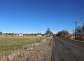
Looking north along Jachim Avenue
|
|

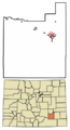
Location of the La Junta Gardens CDP in Otero County, Colorado.
|
|

La Junta Gardens, Colorado
Location in the United States
|
|
| Country | |
| State | |
| County | Otero County |
| Government | |
| • Type | unincorporated community |
| Area | |
| • Total | 0.533 sq mi (1.381 km2) |
| • Land | 0.533 sq mi (1.381 km2) |
| • Water | 0 sq mi (0.000 km2) |
| Elevation | 4,065 ft (1,239 m) |
| Population
(2020)
|
|
| • Total | 123 |
| • Density | 230.7/sq mi (89.1/km2) |
| Time zone | UTC-7 (MST) |
| • Summer (DST) | UTC-6 (MDT) |
| ZIP Code |
La Junta 81050
|
| Area codes | 970 |
| GNIS feature | La Junta Gardens CDP |
La Junta Gardens is a small community located in Otero County, Colorado, in the United States. It is known as a Census-designated place (CDP). This means it's an area that the government identifies for gathering statistics, like how many people live there. However, it doesn't have its own local government, like a city or town would.
In the year 2020, 123 people lived in La Junta Gardens. The community is served by the La Junta post office, which uses the Zip Code 81050.
Geography of La Junta Gardens
La Junta Gardens is a small area of land. It covers about 1.381 square kilometers (or about 341 acres). All of this area is land, meaning there are no large bodies of water like lakes or rivers within its boundaries.
Population and Demographics
The population of La Junta Gardens is counted during the United States Census. This is a big survey that happens every ten years to count everyone living in the United States.
| La Junta Gardens CDP, Colorado | ||
|---|---|---|
| Year | Pop. | ±% |
| 2010 | 153 | — |
| 2020 | 123 | −19.6% |
| Source: United States Census Bureau | ||
The United States Census Bureau first officially recognized La Junta Gardens as a CDP for the United States Census 2010. This helped them keep track of the population in this specific area. In 2010, there were 153 people living here. By 2020, the population had changed to 123 people.
Images for kids
-
Looking north along Jachim Avenue
-
Location of the La Junta Gardens CDP in Otero County, Colorado.
See also
- In Spanish: La Junta Gardens para niños
