El Paso County, Colorado facts for kids
Quick facts for kids
El Paso County
|
|||
|---|---|---|---|
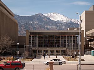
El Paso County Justice Center
|
|||
|
|||
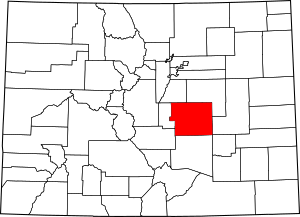
Location within the U.S. state of Colorado
|
|||
 Colorado's location within the U.S. |
|||
| Country | |||
| State | |||
| Founded | November 1, 1861 | ||
| Named for | Spanish name for The Pass | ||
| Seat | Colorado Springs | ||
| Largest city | Colorado Springs | ||
| Area | |||
| • Total | 2,130 sq mi (5,500 km2) | ||
| • Land | 2,127 sq mi (5,510 km2) | ||
| • Water | 2.7 sq mi (7 km2) 0.1%% | ||
| Population
(2020)
|
|||
| • Total | 730,395 | ||
| • Estimate
(2023)
|
744,215 |
||
| • Density | 342.9/sq mi (132.40/km2) | ||
| Time zone | UTC−7 (Mountain) | ||
| • Summer (DST) | UTC−6 (MDT) | ||
| Congressional districts | 4th, 5th | ||
El Paso County is a large county in Colorado, USA. It has the most people of any county in the state. In 2020, over 730,000 people lived here. This means it has even more people than the City and County of Denver. The main city and government center is Colorado Springs. This is also the second-biggest city in Colorado. El Paso County is part of the larger Colorado Springs city area.
Contents
A Look Back: El Paso County's History
In July 1858, people found gold near the South Platte River. This started the exciting Pike's Peak Gold Rush. Many miners felt far away from the governments of Kansas and Nebraska. So, they decided to create their own area called the Territory of Jefferson. This happened on October 24, 1859.
The next month, the Jefferson Territory created 12 counties. One of them was El Paso County. It was named after the Spanish word for "The Pass." This refers to Ute Pass, which is north of Pikes Peak. The first main town for El Paso County was Colorado City.
The Jefferson Territory never got official approval from the U.S. government. But on February 28, 1861, President James Buchanan signed a law. This law created the Territory of Colorado. El Paso County was one of the first 17 counties made by Colorado's government on November 1, 1861.
Later, in 1899, a part of its western land became Teller County. The county's main town moved from Old Colorado City to Colorado Springs in 1873.
Exploring El Paso County's Geography
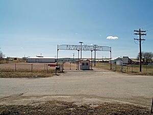
El Paso County covers a total area of about 2,130 square miles. Most of this (2,127 square miles) is land. Only a small part (2.7 square miles) is water.
Neighboring Counties
El Paso County shares borders with several other counties:
- Douglas County - to the north
- Elbert County - to the northeast
- Lincoln County - to the east
- Crowley County - to the southeast
- Pueblo County - to the south
- Fremont County - to the southwest
- Teller County - to the west
Main Roads and Highways
Many important roads run through El Paso County:
 Interstate 25
 I-25 Bus. (Nevada Avenue)
 U.S. Highway 24
 U.S. Highway 85
 State Highway 16 (Mesa Ridge Parkway)
 State Highway 21 (Powers Boulevard)
 State Highway 83
 State Highway 94
 State Highway 105
 State Highway 115
Important Natural and Historic Places
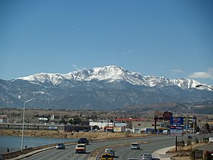
- Pike National Forest: A large forest area for nature and recreation.
- Cheyenne Mountain State Park: A state park with trails and wildlife.
- Pikes Peak National Historic Landmark: A very important historic mountain.
- USAFA Cadet Area National Historic District: A historic part of the Air Force Academy.
- Old Colorado City (National Register of Historic Districts): A historic district that was once the county seat.
- Manitou Springs (National Register of Historic Districts): Another historic district known for its mineral springs.
Fun Trails to Explore
- American Discovery Trail
- Barr National Recreation Trail
- Bear Creek Cañon Park
- Bear Creek Regional Park and Nature Center
- Calhan Paint Mines
- Fountain Creek Nature Center
- The Incline
- New Santa Fe Trail
- Pikes Peak Greenway
- White House Ranch National Recreation Trail
People and Population
| Historical population | |||
|---|---|---|---|
| Census | Pop. | %± | |
| 1870 | 987 | — | |
| 1880 | 7,949 | 705.4% | |
| 1890 | 21,239 | 167.2% | |
| 1900 | 31,602 | 48.8% | |
| 1910 | 43,321 | 37.1% | |
| 1920 | 44,027 | 1.6% | |
| 1930 | 49,570 | 12.6% | |
| 1940 | 54,025 | 9.0% | |
| 1950 | 74,523 | 37.9% | |
| 1960 | 143,742 | 92.9% | |
| 1970 | 235,972 | 64.2% | |
| 1980 | 309,424 | 31.1% | |
| 1990 | 397,014 | 28.3% | |
| 2000 | 516,929 | 30.2% | |
| 2010 | 622,263 | 20.4% | |
| 2020 | 730,395 | 17.4% | |
| 2023 (est.) | 744,215 | 19.6% | |
| U.S. Decennial Census 1790–1960 1900–1990 1990–2000 2010-2020 |
|||
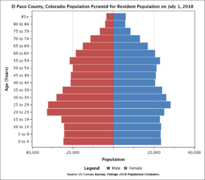
In 2020, there were 730,395 people living in El Paso County. There were over 272,000 households. The county has about 343 people per square mile. Most people (82.6%) were White. Other groups included Black or African American (6.9%), Native American (1.4%), and Asian (3.4%). About 18.9% of the people were Hispanic or Latino.
Learning and Education
Schools for Kids (K-12)
El Paso County has 17 public school districts. It also has many private schools. In the 2023–2024 school year, Cheyenne Mountain School District 12 was ranked the best public school district in Colorado. Academy School District 20 and Lewis-Palmer School District 38 were also in the top ten.
Colleges and Universities
El Paso County is home to several colleges. The United States Air Force Academy is just north of Colorado Springs. It is a university and an Air Force base. Other colleges in the county include the University of Colorado–Colorado Springs, Colorado College, and Pikes Peak State College.
Libraries for Everyone
The Pikes Peak Library District offers library services to most people in El Paso County. It has 15 branches and bookmobiles. Their goal is to provide resources that help people and build community.
Military Bases in El Paso County
El Paso County has several important military bases. These bases are for the Army, Air Force, and Space Force. They are located around Colorado Springs.
Fort Carson: The Mountain Post
Fort Carson is an Army base south of Colorado Springs. It was built in 1942 after the attack on Pearl Harbor. The city of Colorado Springs bought the land and gave it to the War Department. It was named after the famous Army scout, Gen. Christopher "Kit" Carson.
Today, Fort Carson is home to the 4th Infantry Division and other units. It covers about 137,000 acres. It also has a large training area called Piñon Canyon Maneuver Site. Fort Carson has many homes for military families and soldiers. It also has schools, a hospital, and fun places like a bowling alley and golf course.
Fort Carson helps the local economy a lot. In 2014, it added about $2.3 billion to the area. It has about 24,300 soldiers and 44,700 family members.
Peterson Space Force Base
Peterson Space Force Base is very important for the Space Force. It helps with missile defense operations. This base is home to Space Force's Space Operations Command. It also hosts the headquarters for NORAD. Peterson SFB is also the headquarters for the United States Northern Command. This command directs all U.S. military operations in North America.
Peterson SFB is also the current home for US Space Command. This command handles global operations far above Earth.
Schriever Space Force Base
Schriever Space Force Base is home to several Space Force groups. They manage and support 175 Department of Defense satellites. This base is where the Global Positioning System (GPS) master control station is located. It also has the US Naval Observatory Alternate Master Clock. This clock helps keep GPS satellite time accurate. Schriever also helps with national missile defense. The base adds about $1 billion to the Colorado Springs area each year.
United States Air Force Academy
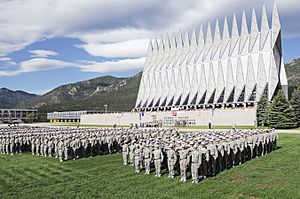
The United States Air Force Academy is on the northwest side of Colorado Springs. Here, cadets train to become officers in the Air Force and Space Force. The campus is famous for its unique chapel. Many visitors come to see it all year. The Academy's sports teams play in the Mountain West Conference.
Cheyenne Mountain Space Force Station
The North American Aerospace Defense Command (NORAD) has a presence at Cheyenne Mountain Space Force Station. This facility was built during the Cold War. It was designed to track ICBMs (long-range missiles). Today, NORAD still operates. Its main job is to track missiles. Some operations have moved to Peterson Space Force Base.
Towns and Communities
Cities in El Paso County
- Colorado Springs (the main city and county seat)
- Fountain
- Manitou Springs
Smaller Towns
- Calhan
- Green Mountain Falls
- Monument
- Palmer Lake
- Ramah
Census-Designated Places (CDPs)
- Air Force Academy
- Black Forest
- Cascade-Chipita Park
- Cimarron Hills
- Ellicott
- Fort Carson
- Gleneagle
- Peyton
- Rock Creek Park
- Security-Widefield
- Stratmoor
- Woodmoor
Other Small Communities
See also
 In Spanish: Condado de El Paso (Colorado) para niños
 | William Lucy |
 | Charles Hayes |
 | Cleveland Robinson |


