Black Forest, Colorado facts for kids
Quick facts for kids
Black Forest, Colorado
|
|
|---|---|

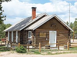
The Black Forest School
|
|

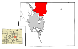
Location of the Black Forest CDP in El Paso County, Colorado.
|
|
| Country | |
| State | |
| County | El Paso County |
| Government | |
| • Type | unincorporated community |
| Area | |
| • Total | 100.698 sq mi (260.807 km2) |
| • Land | 100.640 sq mi (260.657 km2) |
| • Water | 0.058 sq mi (0.150 km2) |
| Elevation | 7,575 ft (2,309 m) |
| Population
(2020)
|
|
| • Total | 15,097 |
| • Density | 149.923/sq mi (57.8857/km2) |
| Time zone | UTC-7 (MST) |
| • Summer (DST) | UTC-6 (MDT) |
| ZIP Code |
Colorado Springs 80908 and Elbert 80106
|
| Area code(s) | 719 |
| GNIS feature | Black Forest CDP |
Black Forest is a special area in Colorado, United States. It is called an "unincorporated community" and a "census-designated place" (CDP). This means it's a recognized area with people living there, but it doesn't have its own city government. Instead, it's managed by El Paso County.
Black Forest is part of the larger Colorado Springs, CO Metropolitan Statistical Area. In 2020, about 15,097 people lived here. The area gets its name from the many Ponderosa Pine trees that grow densely, making it look like a dark forest. In 2006, people living in Black Forest voted against becoming an official city.
Contents
Exploring Black Forest History
The story of Black Forest is linked to a bigger area once known as the "Pineries." This large area stretched for about 1,000 square miles. It was named for its many pine trees. By the early 1900s, the part north of Colorado Springs became known as the "Black Forest."
Early Inhabitants and Timber Use
Evidence like arrowheads shows that Native Americans lived here at least 800 years ago. The first known tribes were the Ute and Comanche. They used the thick pine forests for shelter, fuel, and wood for their homes. Later, the Kiowas, and then the Arapahoe and Cheyenne tribes, lived in the area.
When pioneers arrived in the late 1850s, Black Forest became important. It was a key source of timber, which was hard to find elsewhere. The first sawmills were built in 1860. General Palmer bought 43,000 acres in 1870. He supplied wood for building Colorado Springs and Denver.
Logging was very busy in 1870. Over 700 teamsters and 1,000 lumberjacks worked here. They cut down more than a billion board feet of lumber. This wood was used to build railroads like the Kansas Pacific and Denver and Rio Grande.
Farming, Ranching, and Growth
Even though logging continued until the 1950s, farming and ranching became more important by the 1880s. Farmers grew many crops, including potatoes, which Black Forest became famous for. However, farming was tough due to droughts, floods, and other natural problems. The Dust Bowl and Great Depression in the 1930s made farming even harder. By the 1920s, much of the land became large ranches, some of which still exist today.
Several small towns once existed in the area. The biggest was Eastonville, which started in the 1880s as a railroad stop. It had about 400 people in 1910. Today, only a few signs of the old town remain.
Modern development in Black Forest began in the 1920s with country clubs. These helped the area become a popular spot for summer homes. A big growth in year-round homes happened in the late 1950s and early 1960s. In 1965, most of the area was set up for homes on at least five-acre lots. This helped Black Forest keep its rural feel.
The name "Black Forest" became more official when the Black Forest School opened in 1923. This school is now called Edith Wolford Elementary.
The 2013 Black Forest Fire
On June 11, 2013, a large forest fire started in Black Forest. It began near Highway 83 and Shoup Road. About 35,500 people had to leave their homes in Black Forest and nearby areas.
The fire burned about 15,500 acres of land. Sadly, 511 buildings were destroyed, and two people lost their lives. This fire became the most destructive wildfire in Colorado's history based on the number of homes lost. Firefighters worked hard and had the fire fully contained by June 20, 2013.
Black Forest Geography
The Black Forest CDP covers about 260.807 square kilometers (100.7 square miles). A very small part of this area, about 0.150 square kilometers (0.058 square miles), is water.
Population Changes in Black Forest
The United States Census Bureau first defined Black Forest as a CDP for the 1980 census. Here's how the population has changed over the years:
| Black Forest CDP, Colorado | ||
|---|---|---|
| Year | Pop. | ±% |
| 1980 | 3,372 | — |
| 1990 | 8,143 | +141.5% |
| 2000 | 13,247 | +62.7% |
| 2010 | 13,116 | −1.0% |
| 2020 | 15,097 | +15.1% |
| Source: United States Census Bureau | ||
See also
 In Spanish: Black Forest (Colorado) para niños
 | Audre Lorde |
 | John Berry Meachum |
 | Ferdinand Lee Barnett |


