Crystola, Colorado facts for kids
Quick facts for kids
Crystola, Colorado
|
|
|---|---|

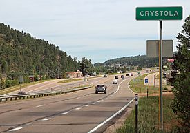
Crystola and U.S. Highway 24.
|
|
| Country | |
| State | |
| County | El Paso County Teller County |
| Elevation | 7,979 ft (2,432 m) |
| Time zone | UTC-7 (MST) |
| • Summer (DST) | UTC-6 (MDT) |
| ZIP code |
80863 (Woodland Park)
|
| Area code(s) | 719 |
| GNIS feature ID | 019202 |
Crystola is a small, quiet community in Colorado, United States. It's special because it's an "unincorporated community." This means it doesn't have its own local government like a city or town. Instead, it's managed by the counties it's in: El Paso County and Teller County. Even though it has its own ZIP code (80863), if you send mail there, you need to address it to Woodland Park.
Contents
Exploring Crystola's Location
Crystola is located in the beautiful state of Colorado. It sits at specific geographic coordinates: 38 degrees, 57 minutes, 21 seconds North latitude and 105 degrees, 1 minute, 38 seconds West longitude. This means it's in a mountainous area, offering great views!
High Up in the Mountains
This community is quite high up! Crystola is about 2,432 meters (or 7,979 feet) above sea level. Being so high means it often has cooler temperatures and can get a lot of snow in winter.
Important Events in Crystola
Like many places, Crystola has experienced significant events. One notable event was in 2012.
The Waldo Canyon Fire Evacuation
On June 27, 2012, the people of Crystola had to leave their homes. This was due to a large wildfire called the Waldo Canyon Fire. A "mandatory evacuation notice" meant everyone had to go to a safer place to protect themselves from the fire. Thankfully, the community recovered from this event.
 | Aurelia Browder |
 | Nannie Helen Burroughs |
 | Michelle Alexander |


