Rush, Colorado facts for kids
Quick facts for kids
Rush, Colorado
|
|
|---|---|

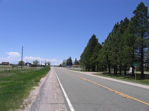
Looking west down Highway 94, Pikes Peak is in the distance
|
|
| Country | |
| State | |
| County | El Paso County |
| Elevation | 6,017 ft (1,834 m) |
| Time zone | UTC-7 (MST) |
| • Summer (DST) | UTC-6 (MDT) |
| ZIP code |
80833
|
| Area code(s) | 719 |
| GNIS feature ID | 0193570 |
Rush is a small place in El Paso County, Colorado, United States. It is known as an unincorporated community. This means it's a settled area that doesn't have its own local government, like a city or town. Instead, it's governed by the county. Rush also has a U.S. Post Office with the ZIP Code 80833.
What's in a Name?
Rush was named after a person named Christopher Rush. He was a homesteader from Missouri. A homesteader was someone who moved to new land to settle it and build a farm or home, often getting the land from the government. Christopher Rush settled in this area in 1907.
Where is Rush Located?
Rush is found in the eastern part of El Paso County. It is about 2 miles (3.2 kilometers) west of the border with Lincoln County. You can find Rush along State Highway 94, east of another community called Yoder. Its exact location is 38°50′45″N 104°05′32″W / 38.84583°N 104.09222°W.
Learning and Schools
The students in Rush are part of the Miami-Yoder School District 60JT. A school district is a local organization that manages public schools in a specific area. This district helps make sure that children in Rush and nearby communities get an education.
 | Isaac Myers |
 | D. Hamilton Jackson |
 | A. Philip Randolph |


