
Chivington, Colorado facts for kids
Quick facts for kids
Chivington, Colorado
|
|
|---|---|

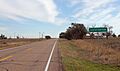
Chivington in 2015
|
|

Chivington, Colorado
Location in Colorado

Chivington, Colorado
Location in the United States
|
|
| Country | |
| State | |
| County | Kiowa County |
| Government | |
| • Type | unincorporated community |
| Elevation | 3,891 ft (1,186 m) |
| Time zone | UTC-7 (MST) |
| • Summer (DST) | UTC-6 (MDT) |
| ZIP Code |
Eads CO 81036
|
Chivington is a small, quiet place in Kiowa County, Colorado, United States. It's known as an unincorporated community, meaning it doesn't have its own local government. If you need to send mail to Chivington, the U.S. Post Office in nearby Eads handles it.
The community was named after Reverend John Chivington. He was a colonel in the Union Army during the American Civil War. He was famous for a battle in 1862. However, he was also involved in a very sad event with Native Americans nearby. This event was later criticized by the United States Congress Joint Committee on the Conduct of the War. The governor at the time, John Evans, even lost his job because of it.
| Top - 0-9 A B C D E F G H I J K L M N O P Q R S T U V W X Y Z |
Discovering Chivington, Colorado
Chivington is a historic spot in Kiowa County. It's located in the eastern plains of Colorado. This area is known for its wide-open spaces. Chivington sits at 38°26′12″N 102°32′32″W / 38.43667°N 102.54222°W. This means it's about 3,891 feet (1,186 meters) above sea level.
How Chivington Got Started
Chivington began in 1887. It was one of many towns built along the Missouri Pacific Railroad line. In the late 1800s, eastern Colorado was a busy place for farming. The railroad helped connect these farming areas. It also brought workers as the tracks extended to places like Colorado Springs and Denver.
The Rise and Fall of a Railroad Town
In its early days, Chivington had many local businesses. A big attraction was the Kingdon Hotel. This hotel was a large, three-story building. It cost $10,000 to build, which was a lot of money back then! It was meant to house railroad workers.
However, the railroad found a problem. The water in Chivington had too much alkali. This made it unsuitable for their train boilers. So, a town in Kansas called Horace became the main watering stop instead. The Kingdon Hotel was taken apart. Its materials were moved to build other buildings in Colorado. This was a common practice at the time.
The Tough Times of the 1920s and 1930s
The 1920s and 1930s brought very hard times. This period included the Dust Bowl and the Great Depression. It became very difficult to farm on Colorado's eastern plains. Because of this, many towns like Chivington slowly faded away. Most of Chivington became a ghost town during these decades.
Chivington Today: A Glimpse into the Past
Today, Chivington is mostly ruins. You can see a few abandoned buildings. Some are still standing, while others have partly collapsed. The old schoolhouse, for example, is slowly falling apart. Piles of bricks show where many buildings once stood.
Green highway signs still mark the spot as "Chivington." The town's post office closed in the 1980s. Now, people in Chivington use the postal service in Eads. Eads also has stores and gas stations.
Lamar is the closest larger town. Chivington is slowly returning to its natural state. It's becoming more like the grassland and prairieland it once was.
A Unique Find: The Ghost Sign
One of the old buildings in Chivington has a special feature. It has a "ghost sign" on its side. This is an old painted advertisement that is still visible. It asks citizens to vote for a man named Jan King. He ran for the office of Kiowa County clerk.
A Stop for Cyclists
Even though it's a quiet place, Chivington gets visitors. The famous TransAmerica Cycling Trail goes right through the community. Hundreds of cyclists ride through Chivington every year. It's a unique stop on their long journey.
Images for kids
-
Chivington in 2015
