
Lamar, Colorado facts for kids
Quick facts for kids
Lamar, Colorado
|
|
|---|---|

Main Street facing north in downtown Lamar (2007)
|
|

Location with Prowers County and Colorado
|
|
| Country | United States |
| State | Colorado |
| County | Prowers County |
| Incorporated | December 5, 1886 |
| Government | |
| • Type | Home Rule Municipality |
| Area | |
| • Total | 5.29 sq mi (13.70 km2) |
| • Land | 5.27 sq mi (13.65 km2) |
| • Water | 0.02 sq mi (0.05 km2) |
| Elevation | 3,619 ft (1,103 m) |
| Population
(2020)
|
|
| • Total | 7,687 |
| • Density | 1,453.1/sq mi (561.09/km2) |
| Time zone | UTC−7 (MST) |
| • Summer (DST) | UTC−6 (MDT) |
| ZIP Code |
81052
|
| Area code | 719 |
| FIPS code | 08-43110 |
| GNIS ID | 203835 |
Lamar is a city in southeastern Colorado. It's the main town and the biggest city in Prowers County. In 2020, about 7,687 people lived there. The city got its name from Lucius Quintus Cincinnatus Lamar. He was a diplomat and later served as a U.S. Secretary of the Interior and a U.S. Supreme Court Justice. Lamar is also home to Lamar Community College.
Contents
History of Lamar
Lamar was started on May 24, 1886, by a person named Issac Holmes. The city was named after Lucius Quintus Cincinnatus Lamar II. He was an important person in the U.S. government. The first city elections happened in December 1886. C. M. Morrison became the first mayor of Lamar.
In 1889, Prowers County was created, and Lamar was chosen to be the county's government center. Over the years, Lamar has faced challenges like fires and floods. The city was also greatly affected by the Dust Bowl in the 1930s. During that time, Lamar took part in big projects to help people and the land.
Scientists are planning to build a special observatory near Lamar. It will be part of the Pierre Auger Observatory. This observatory helps study tiny, super-powerful particles from space called cosmic rays.
Geography and Climate
Lamar is located in southeastern Colorado. It sits on the south side of the Arkansas River floodplain. The city of Las Animas is about 20 miles to the west.
The city covers about 5.29 square miles (13.70 square kilometers) of land.
How to Get Around Lamar
Lamar has different ways for people to travel to and from the city.
Train and Bus Services
You can travel to Lamar by train using Amtrak's Southwest Chief service. The train runs between Chicago and Los Angeles, stopping at the Lamar Amtrak Station. There is also a bus service called Bustang. Lamar is the last stop on the Lamar-Pueblo-Colorado Springs Outrider bus line if you are traveling east.
Major Highways
Several important highways pass through Lamar:
 US 50 is a major highway that goes from California to Maryland. It's the main road to cities like Pueblo and Las Animas.
 US 287 and US 385 are two highways that run together through Lamar. They connect Lamar to Springfield. US 287 goes all the way from Texas to Montana. US 385 goes from Texas to South Dakota.
What is Lamar's Climate Like?
Lamar has a cold semi-arid climate. This means it's generally dry, but not a desert, and it can get cold in winter.
| Climate data for Lamar, Colorado (1991–2020 normals, extremes 1893–present) | |||||||||||||
|---|---|---|---|---|---|---|---|---|---|---|---|---|---|
| Month | Jan | Feb | Mar | Apr | May | Jun | Jul | Aug | Sep | Oct | Nov | Dec | Year |
| Record high °F (°C) | 82 (28) |
86 (30) |
94 (34) |
98 (37) |
103 (39) |
111 (44) |
111 (44) |
110 (43) |
106 (41) |
99 (37) |
89 (32) |
82 (28) |
111 (44) |
| Mean maximum °F (°C) | 66.3 (19.1) |
72.3 (22.4) |
82.9 (28.3) |
88.9 (31.6) |
95.7 (35.4) |
102.7 (39.3) |
103.7 (39.8) |
101.6 (38.7) |
98.3 (36.8) |
90.3 (32.4) |
78.6 (25.9) |
66.5 (19.2) |
105.2 (40.7) |
| Mean daily maximum °F (°C) | 45.1 (7.3) |
49.2 (9.6) |
60.2 (15.7) |
68.4 (20.2) |
77.7 (25.4) |
88.7 (31.5) |
93.3 (34.1) |
90.6 (32.6) |
83.5 (28.6) |
69.9 (21.1) |
56.4 (13.6) |
45.5 (7.5) |
69.0 (20.6) |
| Daily mean °F (°C) | 29.4 (−1.4) |
33.1 (0.6) |
43.3 (6.3) |
52.2 (11.2) |
62.2 (16.8) |
73.1 (22.8) |
78.1 (25.6) |
75.7 (24.3) |
67.5 (19.7) |
53.0 (11.7) |
39.9 (4.4) |
30.0 (−1.1) |
53.1 (11.7) |
| Mean daily minimum °F (°C) | 13.7 (−10.2) |
17.0 (−8.3) |
26.3 (−3.2) |
36.1 (2.3) |
46.8 (8.2) |
57.5 (14.2) |
62.9 (17.2) |
60.9 (16.1) |
51.5 (10.8) |
36.0 (2.2) |
23.3 (−4.8) |
14.4 (−9.8) |
37.2 (2.9) |
| Mean minimum °F (°C) | −1.5 (−18.6) |
2.1 (−16.6) |
10.3 (−12.1) |
21.4 (−5.9) |
32.7 (0.4) |
45.3 (7.4) |
54.5 (12.5) |
53.0 (11.7) |
37.8 (3.2) |
21.1 (−6.1) |
8.7 (−12.9) |
−1.9 (−18.8) |
−7.2 (−21.8) |
| Record low °F (°C) | −29 (−34) |
−30 (−34) |
−23 (−31) |
8 (−13) |
20 (−7) |
33 (1) |
43 (6) |
40 (4) |
23 (−5) |
1 (−17) |
−12 (−24) |
−23 (−31) |
−30 (−34) |
| Average precipitation inches (mm) | 0.33 (8.4) |
0.42 (11) |
0.72 (18) |
1.46 (37) |
1.93 (49) |
2.53 (64) |
2.81 (71) |
2.78 (71) |
1.19 (30) |
1.08 (27) |
0.48 (12) |
0.46 (12) |
16.19 (411) |
| Average snowfall inches (cm) | 6.3 (16) |
5.4 (14) |
4.7 (12) |
1.7 (4.3) |
0.1 (0.25) |
0.0 (0.0) |
0.0 (0.0) |
0.0 (0.0) |
0.0 (0.0) |
2.1 (5.3) |
3.6 (9.1) |
5.9 (15) |
29.8 (76) |
| Average precipitation days (≥ 0.01 in) | 2.7 | 3.0 | 4.2 | 5.8 | 7.5 | 7.4 | 8.3 | 7.4 | 4.6 | 4.3 | 3.4 | 3.2 | 61.8 |
| Average snowy days (≥ 0.1 in) | 2.2 | 2.0 | 1.5 | 0.8 | 0.1 | 0.0 | 0.0 | 0.0 | 0.0 | 0.4 | 1.3 | 2.1 | 10.4 |
| Source: NOAA | |||||||||||||
People of Lamar
| Historical population | |||
|---|---|---|---|
| Census | Pop. | %± | |
| 1890 | 566 | — | |
| 1900 | 987 | 74.4% | |
| 1910 | 2,977 | 201.6% | |
| 1920 | 2,512 | −15.6% | |
| 1930 | 4,233 | 68.5% | |
| 1940 | 4,445 | 5.0% | |
| 1950 | 6,829 | 53.6% | |
| 1960 | 7,369 | 7.9% | |
| 1970 | 7,797 | 5.8% | |
| 1980 | 7,713 | −1.1% | |
| 1990 | 8,343 | 8.2% | |
| 2000 | 8,869 | 6.3% | |
| 2010 | 7,804 | −12.0% | |
| 2020 | 7,687 | −1.5% | |
| U.S. Decennial Census | |||
In 2010, there were 7,804 people living in Lamar. These people made up 3,102 households and 1,980 families. The city had about 1,858 people per square mile.
Most of the people in Lamar were White (78.6%). About 16.3% were from other races, and 3.0% were from two or more races. A large part of the population, 39.7%, identified as Hispanic or Latino.
The average household had 2.43 people, and the average family had 3.07 people. About 27.8% of the population was under 18 years old. The median age in the city was 34.1 years.
The median income for a household in Lamar was $31,521. For families, the median income was $43,588. About 24.6% of all people in Lamar lived below the poverty line. This included 34.1% of those under 18.
Education in Lamar
Lamar is part of School District RE-2. The city is also home to Lamar Community College. This college offers different programs for students after high school.
Famous People from Lamar
Many notable people have either been born in Lamar or lived there. Here are a few:
- Gordon L. Allott (1907–1989), a U.S. Senator from Colorado.
- Marvin Ash (1914–1974), a jazz pianist.
- Ken Curtis (1916–1991), an actor and singer.
- Scott Elarton (1976- ), a baseball pitcher.
- Curt Gentry (1931–2014), a journalist and author.
- Gerald Gregg (1907–1985), an illustrator and book cover artist.
- Wayne R. Grisham (1923–2011), a U.S. Representative from California.
- Floyd D. Hall (1916–2012), a pilot and airline executive.
- Sharon Herbaugh (1954–1993), a war correspondent for the Associated Press.
- Wesley Tuttle (1917–2003), a singer-songwriter and guitarist.
- Sandy Vance (1947- ), a baseball pitcher.
Images for kids
-
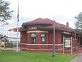
Restored railroad depot and Lamar visitor center

See also
 In Spanish: Lamar (Colorado) para niños
