Eads, Colorado facts for kids
Quick facts for kids
Eads, Colorado
|
|
|---|---|

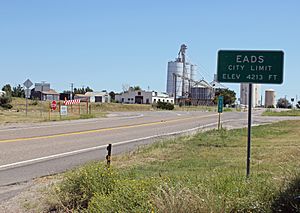
Eads from the west on State Highway 96 (2013)
|
|

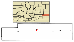
Location within Kiowa County and Colorado
|
|
| Country | United States |
| State | Colorado |
| County | Kiowa |
| Founded | 1887 |
| Incorporated | January 29, 1916 |
| Area | |
| • Total | 0.478 sq mi (1.237 km2) |
| • Land | 0.478 sq mi (1.237 km2) |
| • Water | 0 sq mi (0.000 km2) |
| Elevation | 4,219 ft (1,286 m) |
| Population
(2020)
|
|
| • Total | 672 |
| • Density | 1,407.0/sq mi (543.2/km2) |
| Time zone | UTC−7 (MST) |
| • Summer (DST) | UTC−6 (MDT) |
| ZIP Code |
81036
|
| Area code | 719 |
| FIPS code | 08-22145 |
| GNIS ID | 204823 |
Eads is a small town in Colorado, United States. It is the main town and county seat of Kiowa County. In 2020, about 672 people lived there.
Contents
History of Eads
Eads became the main town of Kiowa County in 1901. The town started in 1887 because of the railroad. It was named after James Buchanan Eads. He was an engineer who designed the famous Eads Bridge over the Mississippi River. He also helped make the Mississippi River easier for ships to use.
Many old houses and buildings in Eads are still used today. You can visit places on Maine Street to learn more about the town's past. Since 2007, there's a yearly event called the "Maine Street Bash." It helps local businesses and has fun activities and live shows. Eads was first called Dayton.
Geography and Location
Eads is located in Colorado at coordinates 38.480465 degrees North and -102.780763 degrees West. According to the 2020 United States Census, the town covers about 1.237 square kilometers (0.478 square miles) of land. There is no water area within the town limits.
Eads Climate and Weather
Eads has a climate with warm summers and cold winters. Here's a quick look at the weather:
- Hottest Month: July, with average highs around 91.2°F (32.9°C).
- Coldest Month: January, with average lows around 15.9°F (-8.9°C).
- Rainfall: The town gets about 15.70 inches (399 mm) of rain each year. The most rain falls in July.
- Snowfall: Eads usually gets about 13.9 inches (35.3 cm) of snow per year. January and December are the snowiest months.
| Climate data for Eads, Colorado (1991–2020 normals, extremes 1907–present) | |||||||||||||
|---|---|---|---|---|---|---|---|---|---|---|---|---|---|
| Month | Jan | Feb | Mar | Apr | May | Jun | Jul | Aug | Sep | Oct | Nov | Dec | Year |
| Record high °F (°C) | 78 (26) |
84 (29) |
90 (32) |
99 (37) |
106 (41) |
110 (43) |
110 (43) |
108 (42) |
107 (42) |
96 (36) |
86 (30) |
78 (26) |
110 (43) |
| Mean maximum °F (°C) | 66.3 (19.1) |
70.5 (21.4) |
80.4 (26.9) |
86.4 (30.2) |
93.2 (34.0) |
100.2 (37.9) |
101.7 (38.7) |
99.0 (37.2) |
95.7 (35.4) |
88.5 (31.4) |
76.2 (24.6) |
66.6 (19.2) |
103.0 (39.4) |
| Mean daily maximum °F (°C) | 44.8 (7.1) |
47.6 (8.7) |
58.0 (14.4) |
65.6 (18.7) |
75.4 (24.1) |
86.6 (30.3) |
91.2 (32.9) |
88.6 (31.4) |
81.5 (27.5) |
68.5 (20.3) |
55.0 (12.8) |
45.0 (7.2) |
67.3 (19.6) |
| Daily mean °F (°C) | 30.3 (−0.9) |
33.2 (0.7) |
42.6 (5.9) |
50.3 (10.2) |
60.7 (15.9) |
71.5 (21.9) |
76.4 (24.7) |
74.2 (23.4) |
66.1 (18.9) |
52.6 (11.4) |
40.0 (4.4) |
30.8 (−0.7) |
52.4 (11.3) |
| Mean daily minimum °F (°C) | 15.9 (−8.9) |
18.8 (−7.3) |
27.2 (−2.7) |
35.0 (1.7) |
46.0 (7.8) |
56.5 (13.6) |
61.6 (16.4) |
59.8 (15.4) |
50.8 (10.4) |
36.8 (2.7) |
25.0 (−3.9) |
16.6 (−8.6) |
37.5 (3.1) |
| Mean minimum °F (°C) | −1.1 (−18.4) |
1.2 (−17.1) |
11.2 (−11.6) |
21.2 (−6.0) |
33.1 (0.6) |
46.0 (7.8) |
54.3 (12.4) |
52.3 (11.3) |
37.8 (3.2) |
21.8 (−5.7) |
8.7 (−12.9) |
−1.6 (−18.7) |
−7.2 (−21.8) |
| Record low °F (°C) | −29 (−34) |
−24 (−31) |
−21 (−29) |
4 (−16) |
17 (−8) |
30 (−1) |
36 (2) |
38 (3) |
20 (−7) |
1 (−17) |
−12 (−24) |
−24 (−31) |
−29 (−34) |
| Average precipitation inches (mm) | 0.26 (6.6) |
0.42 (11) |
0.78 (20) |
1.76 (45) |
2.13 (54) |
2.02 (51) |
2.92 (74) |
2.53 (64) |
0.86 (22) |
1.22 (31) |
0.41 (10) |
0.39 (9.9) |
15.70 (399) |
| Average snowfall inches (cm) | 2.5 (6.4) |
3.4 (8.6) |
1.9 (4.8) |
0.6 (1.5) |
0.2 (0.51) |
0.0 (0.0) |
0.0 (0.0) |
0.0 (0.0) |
0.0 (0.0) |
0.2 (0.51) |
2.4 (6.1) |
2.7 (6.9) |
13.9 (35) |
| Average precipitation days (≥ 0.01 in) | 3.0 | 3.3 | 4.3 | 5.5 | 6.8 | 6.3 | 7.5 | 6.8 | 3.9 | 4.0 | 2.8 | 3.1 | 57.3 |
| Average snowy days (≥ 0.1 in) | 1.2 | 1.5 | 0.9 | 0.3 | 0.1 | 0.0 | 0.0 | 0.0 | 0.0 | 0.2 | 0.8 | 0.9 | 5.9 |
| Source: NOAA | |||||||||||||
People Living in Eads
The number of people living in Eads has changed over the years. Here's how the population has grown and shrunk:
| Historical population | |||
|---|---|---|---|
| Census | Pop. | %± | |
| 1920 | 406 | — | |
| 1930 | 518 | 27.6% | |
| 1940 | 700 | 35.1% | |
| 1950 | 1,015 | 45.0% | |
| 1960 | 929 | −8.5% | |
| 1970 | 795 | −14.4% | |
| 1980 | 878 | 10.4% | |
| 1990 | 780 | −11.2% | |
| 2000 | 747 | −4.2% | |
| 2010 | 609 | −18.5% | |
| 2020 | 672 | 10.3% | |
| U.S. Decennial Census | |||
In 2000, there were 747 people living in Eads. Most people (about 95.85%) were White. A small number of people were African American, Native American, or from other backgrounds. About 2.95% of the population was Hispanic or Latino.
There were 320 households in Eads in 2000. About 25% of these households had children under 18. Many households (50%) were married couples. The average household had 2.26 people.
The median age in Eads in 2000 was 41 years old. This means half the people were older than 41 and half were younger. About 23.4% of the population was under 18.
Education in Eads
Eads has its own school district. In the 2006–2007 school year, about 165 students were enrolled from kindergarten to 12th grade. Eads High School had 65 students during that time.
Because it's a smaller school, Eads High School was special. It was the first high school in Colorado to give every student a laptop computer. It also moved to a learning system that mostly used computers.
See also
 In Spanish: Eads (Colorado) para niños
 | Delilah Pierce |
 | Gordon Parks |
 | Augusta Savage |
 | Charles Ethan Porter |

