Kiowa, Colorado facts for kids
Quick facts for kids
Kiowa, Colorado
|
|
|---|---|

Kiowa, Colorado
|
|

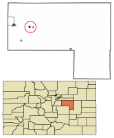
Location of Kiowa in Elbert County, Colorado.
|
|
| Country | |
| State | |
| County | Elbert County Seat |
| Incorporated | December 30, 1912 |
| Government | |
| • Type | Home Rule Municipality |
| Area | |
| • Total | 0.86 sq mi (2.23 km2) |
| • Land | 0.86 sq mi (2.23 km2) |
| • Water | 0.00 sq mi (0.00 km2) |
| Elevation | 6,378 ft (1,944 m) |
| Population
(2020)
|
|
| • Total | 725 |
| • Density | 843/sq mi (325.1/km2) |
| Time zone | UTC-7 (MST) |
| • Summer (DST) | UTC-6 (MDT) |
| ZIP code |
80117
|
| Area code(s) | Both 303 and 720 |
| FIPS code | 08-40790 |
| GNIS feature ID | 0185146 |
Kiowa is a small town in Colorado, United States. It is the main town, or county seat, of Elbert County. In 2020, about 725 people lived in Kiowa. It is known as a "home rule municipality," which means it has its own local government rules.
Contents
History of Kiowa
Kiowa got its name from the Kiowa people. The town was first settled in 1859. At first, it was called "Wendling" after an early settler.
Changing Names
From the 1860s until 1912, the town was known as "Middle Kiowa." In 1912, it officially became an incorporated town. At that time, the word "Middle" was dropped, and it became simply "Kiowa."
County Seat Status
Kiowa became the county seat of Elbert County in 1874. This means it is where the county government offices are located.
Major Flood of 1935
In 1935, Kiowa experienced a big flood. This event caused significant damage to the town.
Geography of Kiowa
Kiowa is located in the western part of Elbert County. It sits on the east side of Kiowa Creek. This creek flows north and eventually joins the South Platte River.
Location and Nearby Towns
Colorado State Highway 86 runs right through Kiowa. This highway connects Kiowa to other towns. If you go east on Highway 86, you will reach Limon, about 44 miles away. Going west for about 23 miles will take you to Castle Rock. The town of Elizabeth is also nearby, about 7 miles west on Highway 86.
Size of the Town
According to the United States Census Bureau, Kiowa covers a total area of about 2.3 square kilometers (0.86 square miles). All of this area is land.
Population of Kiowa
The population of a town tells us how many people live there. Kiowa's population has changed over the years.
| Historical population | |||
|---|---|---|---|
| Census | Pop. | %± | |
| 1920 | 148 | — | |
| 1930 | 185 | 25.0% | |
| 1940 | 195 | 5.4% | |
| 1950 | 173 | −11.3% | |
| 1960 | 195 | 12.7% | |
| 1970 | 235 | 20.5% | |
| 1980 | 206 | −12.3% | |
| 1990 | 275 | 33.5% | |
| 2000 | 581 | 111.3% | |
| 2010 | 723 | 24.4% | |
| 2020 | 725 | 0.3% | |
| U.S. Decennial Census | |||
As you can see from the chart, Kiowa's population has grown quite a bit since 1920. In 2020, 725 people called Kiowa home.
Places of Worship
Kiowa has several churches where people can gather for religious services. These include:
- Kiowa Creek Community Church
- Majestic View Church
- Nazarene Church
- Graceway Bible Church
- Our Lady of the Visitation Parish
- Save the Cowboy
See also
 In Spanish: Kiowa (Colorado) para niños
 | George Robert Carruthers |
 | Patricia Bath |
 | Jan Ernst Matzeliger |
 | Alexander Miles |

