Limon, Colorado facts for kids
Quick facts for kids
Limon, Colorado
|
|
|---|---|

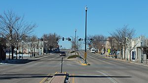
Limon (2012)
|
|

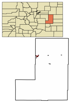
Location within Lincoln County and Colorado
|
|
| Country | United States |
| State | Colorado |
| County | Lincoln |
| Incorporated | November 18, 1909 |
| Area | |
| • Total | 3.19 sq mi (8.27 km2) |
| • Land | 3.16 sq mi (8.19 km2) |
| • Water | 0.03 sq mi (0.08 km2) |
| Elevation | 5,378 ft (1,639 m) |
| Population
(2020)
|
|
| • Total | 2,043 |
| • Density | 640.4/sq mi (247.04/km2) |
| Time zone | UTC−7 (MST) |
| • Summer (DST) | UTC−6 (MDT) |
| ZIP Codes |
80826, 80828
|
| Area code | 719 |
| FIPS code | 08-44980 |
| GNIS ID | 204819 |
Limon is a town in Lincoln County, Colorado, in the United States. In 2020, about 2,043 people lived there. It is the biggest town in Lincoln County. Limon is a very important place for travel. It sits where several major roads meet. These include Interstate 70, U.S. Highway 24, U.S. Highway 40, U.S. Highway 287, and Colorado Highway 71.
Contents
History of Limon
Railroads were key to how Limon started and where it is today. In 1870, the Kansas Pacific Railroad built tracks across the plains. Then, in 1888, the Chicago, Rock Island, and Pacific Railroad (now the Kyle Railroad) came from Colorado Springs. It met the Kansas Pacific line (now Union Pacific) right where Limon is now. This meeting of the two railroads led to the town being called the "Hub City."
The 1990 Tornado Disaster
On June 6, 1990, a powerful F3 tornado hit Limon. It first touched down near Matheson, about 16 miles west. The tornado then moved east, causing huge damage to the town.
Even though much of Limon's business area was destroyed, no one was killed. Only 14 people were hurt, which was amazing for such a strong storm. The next day, Governor Roy Romer said Limon was a disaster area.
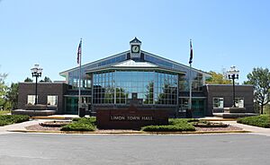
After the tornado, the people of Limon worked hard to rebuild. They fixed up the downtown area, built a new Town Hall, and moved the medical clinic and library. They also created the Hub City Senior Center and a new fire station. Today, downtown Limon is a busy and strong part of the community.
Geography and Location
Limon is located at 39°15′50″N 103°41′32″W / 39.26389°N 103.69222°W. It sits at an elevation of about 5,377 feet (1,639 m) above sea level. The town is entirely in Lincoln County. However, it is very close to the border of Elbert County.
Limon is on the north side of Big Sandy Creek. This creek flows into the Arkansas River. The town is on the eastern edge of the Colorado Piedmont region. This area is part of the larger Great Plains. Limon is also near the eastern end of the Palmer Divide.
Because of its location, Limon is a central point for many highways. It is about 72 miles (116 km) northeast of Colorado Springs. It is also about 83 miles (134 km) southeast of Denver. The town covers an area of about 1.9 square miles (4.9 km2).
Limon's Climate
Limon has a semi-arid climate. This means it has cold, dry winters. Summers are warm and a bit wetter. Because it's on the eastern plains, Limon often gets strong thunderstorms in the summer. These storms can bring large hail, strong winds, heavy rain, and even tornadoes.
Temperatures in Limon can get quite warm. It reaches or goes above 90 °F (32 °C) about 32 days a year. It rarely gets to 100 °F (38 °C). Winters are cold, with temperatures falling below freezing (32 °F (0 °C)) for about 196 days a year. The first freeze usually happens in late September. The last freeze is typically in late May.
Limon gets about 14.97 inches (380 mm) of rain each year. It rains or snows on about 81 days. The hottest temperature ever recorded was 104 °F (40 °C) on July 20, 2005. The coldest was −28 °F (−33 °C) on February 14, 2021.
| Climate data for Limon, Colorado, 1991–2020 normals, extremes 1948–present | |||||||||||||
|---|---|---|---|---|---|---|---|---|---|---|---|---|---|
| Month | Jan | Feb | Mar | Apr | May | Jun | Jul | Aug | Sep | Oct | Nov | Dec | Year |
| Record high °F (°C) | 74 (23) |
79 (26) |
82 (28) |
88 (31) |
97 (36) |
103 (39) |
104 (40) |
102 (39) |
98 (37) |
90 (32) |
88 (31) |
75 (24) |
104 (40) |
| Mean maximum °F (°C) | 64.0 (17.8) |
65.4 (18.6) |
74.3 (23.5) |
80.6 (27.0) |
86.8 (30.4) |
94.9 (34.9) |
97.8 (36.6) |
94.7 (34.8) |
91.0 (32.8) |
83.7 (28.7) |
73.8 (23.2) |
65.1 (18.4) |
98.1 (36.7) |
| Mean daily maximum °F (°C) | 42.7 (5.9) |
43.9 (6.6) |
53.9 (12.2) |
60.5 (15.8) |
69.8 (21.0) |
81.1 (27.3) |
87.2 (30.7) |
84.5 (29.2) |
77.1 (25.1) |
64.1 (17.8) |
51.9 (11.1) |
42.3 (5.7) |
63.2 (17.4) |
| Daily mean °F (°C) | 26.5 (−3.1) |
28.2 (−2.1) |
37.3 (2.9) |
44.3 (6.8) |
53.9 (12.2) |
64.3 (17.9) |
70.4 (21.3) |
68.5 (20.3) |
59.9 (15.5) |
46.7 (8.2) |
34.9 (1.6) |
26.1 (−3.3) |
46.8 (8.2) |
| Mean daily minimum °F (°C) | 10.3 (−12.1) |
12.5 (−10.8) |
20.6 (−6.3) |
28.2 (−2.1) |
38.0 (3.3) |
47.6 (8.7) |
53.6 (12.0) |
52.5 (11.4) |
42.7 (5.9) |
29.3 (−1.5) |
17.9 (−7.8) |
9.9 (−12.3) |
30.3 (−1.0) |
| Mean minimum °F (°C) | −9.4 (−23.0) |
−6.8 (−21.6) |
4.9 (−15.1) |
14.1 (−9.9) |
25.6 (−3.6) |
37.2 (2.9) |
46.1 (7.8) |
44.3 (6.8) |
30.6 (−0.8) |
13.1 (−10.5) |
−0.4 (−18.0) |
−8.9 (−22.7) |
−14.7 (−25.9) |
| Record low °F (°C) | −30 (−34) |
−28 (−33) |
−22 (−30) |
−4 (−20) |
17 (−8) |
26 (−3) |
36 (2) |
36 (2) |
17 (−8) |
−9 (−23) |
−21 (−29) |
−27 (−33) |
−30 (−34) |
| Average precipitation inches (mm) | 0.27 (6.9) |
0.36 (9.1) |
0.80 (20) |
1.37 (35) |
2.21 (56) |
2.20 (56) |
2.53 (64) |
2.72 (69) |
0.96 (24) |
0.84 (21) |
0.40 (10) |
0.31 (7.9) |
14.97 (378.9) |
| Average snowfall inches (cm) | 5.7 (14) |
5.4 (14) |
6.9 (18) |
5.0 (13) |
1.5 (3.8) |
0.0 (0.0) |
0.0 (0.0) |
0.0 (0.0) |
0.2 (0.51) |
3.1 (7.9) |
8.8 (22) |
5.4 (14) |
42.0 (107) |
| Average precipitation days (≥ 0.01 in) | 3.9 | 4.4 | 6.5 | 7.9 | 10.1 | 8.7 | 10.3 | 10.0 | 5.8 | 5.4 | 4.7 | 3.6 | 81.3 |
| Average snowy days (≥ 0.1 in) | 4.5 | 4.4 | 5.5 | 3.5 | 0.7 | 0.0 | 0.0 | 0.0 | 0.4 | 1.6 | 4.6 | 5.1 | 30.3 |
| Source 1: National Weather Service | |||||||||||||
| Source 2: NOAA (average snowfall/snowy days 1981–2010) | |||||||||||||
People of Limon
| Historical population | |||
|---|---|---|---|
| Census | Pop. | %± | |
| 1910 | 534 | — | |
| 1920 | 1,047 | 96.1% | |
| 1930 | 1,100 | 5.1% | |
| 1940 | 1,053 | −4.3% | |
| 1950 | 1,471 | 39.7% | |
| 1960 | 1,811 | 23.1% | |
| 1970 | 1,814 | 0.2% | |
| 1980 | 1,805 | −0.5% | |
| 1990 | 1,831 | 1.4% | |
| 2000 | 2,071 | 13.1% | |
| 2010 | 1,880 | −9.2% | |
| 2020 | 2,043 | 8.7% | |
| U.S. Decennial Census | |||
In 2010, there were 1,880 people living in Limon. They lived in 828 households. About 476 of these were families. The town had 963 housing units.
Most people in Limon were White (93.2%). A small number were American Indian (0.9%), African American (0.8%), or Asian (0.8%). About 9.4% of the people were Hispanic or Latino.
Many households (32.9%) had children under 18. About 41.9% were married couples. The average household had 2.27 people. The average family had 3.00 people.
The median age in Limon was 37.6 years old. About 27.4% of the population was under 18. About 16.2% were 65 or older. In 2009, the average income for a household was $40,903. For a family, it was $46,061.
Limon's Economy
The Limon Correctional Facility is a big employer in the area. It is part of Colorado's prison system. About 350 people work there.
Limon is also important for railroads. The Kyle Railroad ends here. It connects with the Union Pacific Railroad. This helps move goods and materials.
Education in Limon
Limon has great schools and learning centers.
Limon Schools
Limon Schools opened a new building in 2015. It cost $22.5 million to build. This new facility has two stories of classrooms. It can hold up to 600 students from kindergarten to 12th grade.
- Limon Elementary School: This public school has about 240 students in grades K-5. About 82% of students here are good at math or reading.
- Limon Junior-Senior High School: This school has 233 students in grades 6-12. About 77% of students are good at reading. The graduation rate is high, at 90%.
Morgan Community College: Limon Center
This college center helps students from several local high schools. It offers different types of college degrees. Students can take classes that transfer to other colleges. They can also study nursing, agriculture, and business. The center helps people prepare for the GED test. It also offers classes for teachers and computer training.
Limon Child Development Center
The Limon Child Development Center (Limon Head Start) has a full-day preschool program. It is for children aged 3 to 5. Different programs help families pay for preschool.
Media and News
Limon has its own local newspaper and radio stations.
Print Media
The Limon Leader is the town's weekly newspaper. It is published by Hoffman Publications, LLC. About 3,200 copies are printed each week.
Radio Stations
Several radio stations are based in or broadcast to Limon:
AM Radio
| Frequency | Callsign | Format | City of License | Notes |
|---|---|---|---|---|
| 1120 | KCRN | Adult Contemporary | Limon, Colorado | - |
FM Radio
| Frequency | Callsign | Format | City of License | Notes |
|---|---|---|---|---|
| 89.1 | KYCO | Limon, Colorado | - | |
| 89.9 | K210CC | Public | Limon, Colorado | NPR; Translator of KRCC, Colorado Springs, Colorado |
| 91.9 | K220IK | Religious | Limon, Colorado | Translator of KAWZ, Twin Falls, Idaho |
| 93.7 | KBUD | Classic Hits | Limon, Colorado | - |
Television
Limon is part of the Denver television market. This means it receives TV channels from Denver.
Transportation Hub
Limon is a key transportation spot in Colorado.
Highways Connecting Limon
- Interstate 70: This highway goes east to Kansas and west to Denver.
- U.S. Highway 40/287 and Colorado Highway 71: These roads are part of the Ports-to-Plains Corridor. They connect Limon to Texas in the south and South Dakota in the north.
- Colorado State Highway 71: This road goes south from Limon to Pueblo.
- U.S. Route 24: This highway offers a direct route southwest from Limon to Colorado Springs.
Railroads Serving Limon
Limon is served by two important railroads:
- The Union Pacific Railroad
- The Kyle Railroad: This short-line railroad is owned by Genesee & Wyoming, Inc. It runs from North Central Kansas into Eastern Colorado. Limon is where it connects with the Union Pacific Railroad.
Aviation and Airports
Limon is close to major airports:
- Denver International Airport: This is the largest airport in Colorado. It is about 83 miles (134 km) from Limon.
- Colorado Springs Airport: This airport is about 74 miles (119 km) from Limon.
Limon also has its own airport:
- Limon Municipal Airport: This public airport is on the eastern edge of town. It has two runways and covers about 397 acres (161 ha). The town government owns and runs it. The airport is used by many types of aircraft, from small single-engine planes to business jets.
See also
 In Spanish: Limón (Colorado) para niños
 | Precious Adams |
 | Lauren Anderson |
 | Janet Collins |


