Matheson, Colorado facts for kids
Quick facts for kids
Matheson, Colorado
|
|
|---|---|

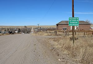
Looking north on Main Street (County Road 149) from the town's south side, November 2021
|
|
| Country | |
| State | |
| County | Elbert County |
| Government | |
| • Type | unincorporated community |
| Area | |
| • Total | 1.716 sq mi (4.444 km2) |
| • Land | 1.716 sq mi (4.444 km2) |
| • Water | 0 sq mi (0.000 km2) |
| Elevation | 5,843 ft (1,781 m) |
| Population
(2020)
|
|
| • Total | 79 |
| • Density | 46.04/sq mi (17.78/km2) |
| Time zone | UTC-7 (MST) |
| • Summer (DST) | UTC-6 (MDT) |
| ZIP Code |
80830
|
| Area code(s) | 719 |
| GNIS feature | Matheson CDP |
Matheson is a small community in Elbert County, Colorado, United States. It's known as a "census-designated place" (CDP). This means it's an area defined by the government just for counting people.
Matheson has its own post office with the ZIP Code 80830. In 2020, only 79 people lived there. Even though it's small, Matheson is part of the larger Denver–Aurora–Lakewood, CO Metropolitan Statistical Area.
Contents
How Matheson Got Its Name
Matheson was named after a person called Duncan Matheson. He was the first owner of the land where the community now stands.
Where is Matheson?
Matheson is located in Elbert County, Colorado. It covers an area of about 4.44 square kilometers. That's about 1.7 square miles, and it's all land.
How Many People Live Here?
According to the United States Census 2020, Matheson is a very small place. Only 79 people lived there in 2020. The United States Census Bureau helps define these areas to count everyone.
Matheson in TV Shows
You might have heard of Matheson from the TV show Honey, I Shrunk the Kids: The TV Show. The show is set in Matheson, Colorado. However, the TV version of Matheson is much bigger and has lots of high-tech businesses. It's also shown as being in the mountains west of Denver, which is different from the real Matheson.
 | Kyle Baker |
 | Joseph Yoakum |
 | Laura Wheeler Waring |
 | Henry Ossawa Tanner |


