
Castle Rock, Colorado facts for kids
Quick facts for kids
Castle Rock, Colorado
|
|
|---|---|

Looking down Wilcox Street in Castle Rock
|
|

Location of the Town of Castle Rock in Douglas County, Colorado
|
|
| Country | United States |
| State | Colorado |
| County | Douglas |
| Founded | 1874 |
| Incorporated | April 14, 1881 |
| Government | |
| • Type | Home rule municipality |
| Area | |
| • Town | 34.742 sq mi (89.981 km2) |
| • Land | 34.742 sq mi (89.981 km2) |
| • Water | 0.000 sq mi (0.000 km2) |
| Elevation | 6,283 ft (1,915 m) |
| Population
(2020)
|
|
| • Town | 73,158 |
| • Rank | US: 445th CO: 14th |
| • Density | 2,308.19/sq mi (891.19/km2) |
| • Urban | 2,686,147 (US: 18th) |
| • Metro | 2,985,871 (US: 19th) |
| • Combined | 3,663,515 (US: 18th) |
| • Front Range | 5,055,344 |
| Time zone | UTC–7 (Mountain (MST)) |
| • Summer (DST) | UTC–6 (MDT) |
| ZIP Codes |
80104, 80108, 80109
|
| Area code(s) | 303, 720, and 983 |
| FIPS code | 08-12415 |
| GNIS feature ID | 2413179 |
| Major Routes | |
| Sales tax | 7.9% |
Castle Rock is a town in Colorado, United States. It is the main town and county seat of Douglas County. The town is named after a large, castle-shaped rock formation nearby.
In 2020, about 73,158 people lived in Castle Rock. This was a big increase from 2010. Castle Rock is the most populated town in Colorado. It is also the 14th largest city or town in the state. Castle Rock is part of the larger Denver-Aurora-Lakewood, CO Metropolitan Statistical Area.
Contents
History of Castle Rock

Long ago, the Arapaho and Cheyenne tribes lived in the area around Castle Rock. They lived between the Arkansas and South Platte Rivers.
Later, settlers came looking for gold. But they found a special stone called rhyolite instead. This stone helped the town grow.
Castle Rock was started in 1874. It became the county seat because it was in the middle of Douglas County.
Jeremiah Gould was one of the first settlers. He owned land near the "Castle Rock" formation. In 1874, he gave 120 acres (0.49 km2) for the new town. Six main streets were planned. People bought lots to build homes and businesses.
A new train station brought the Denver and Rio Grande Railway to the town. This helped Castle Rock connect with other places.
In the late 1800s and early 1900s, many people worked in the rhyolite quarries. Immigrants came to the area for these jobs.
In 1936, the town received the land with its famous rock. Workers built a star on top of the butte. The star was lit every year until 1941. During World War II, it was left unlit to show support for the war. After the war, it was changed to a "V" for victory. Since 1945, the star has been lit every holiday season.
The old county courthouse, built in 1889, burned down in 1978. It was set on fire.
In the 1980s, the town had money problems. In 1984, people voted to create a "home-rule" charter. This gave the town more control over its own rules. The charter was finished in 1987.
Seven buildings in Castle Rock are on the National Register of Historic Places. These include the old train station and the first national bank.
In 2005, the U.S. Supreme Court made a decision about Castle Rock. The court said that a town's police department cannot be sued for not enforcing certain civil orders. This case helped clarify what police departments are responsible for.
Geography of Castle Rock

Castle Rock is in central Colorado. It is where Interstate 25 and State Highway 86 meet. The town is about 28 miles (45 km) south of Denver. It is 37 miles (60 km) north of Colorado Springs.
The town is near the Rampart Range of the Rocky Mountains. It is also on the edge of the Great Plains. The "Castle Rock" butte is just north of the town center. You can also see other famous mountains like Pikes Peak from Castle Rock.
East Plum Creek flows through Castle Rock. Many smaller streams also run into it.
Castle Rock is in the Colorado Foothills Life Zone. The hills have grassy meadows and ponderosa pine trees. You might also see Gambel oak and pinyon pine. Local animals include coyotes, mule deer, bobcats, and skunks. Birds like the golden eagle and red-tailed hawk also live here.
The town covers about 35 square miles (90 km2) of land. It is part of the larger Denver metropolitan area. Castle Rock is next to towns like Castle Pines and The Pinery.
Castle Rock's Climate
Castle Rock has a semiarid climate. This means it has cold, dry, and snowy winters. Summers are hot and wetter. January is usually the coldest month. July is the hottest. August gets the most rain.
| Climate data for Castle Rock, Colorado, 1991–2020 normal, extremes 1893–present | |||||||||||||
|---|---|---|---|---|---|---|---|---|---|---|---|---|---|
| Month | Jan | Feb | Mar | Apr | May | Jun | Jul | Aug | Sep | Oct | Nov | Dec | Year |
| Record high °F (°C) | 73 (23) |
75 (24) |
82 (28) |
91 (33) |
94 (34) |
101 (38) |
102 (39) |
99 (37) |
101 (38) |
88 (31) |
85 (29) |
82 (28) |
102 (39) |
| Mean maximum °F (°C) | 64.5 (18.1) |
64.6 (18.1) |
72.8 (22.7) |
77.7 (25.4) |
84.9 (29.4) |
92.7 (33.7) |
95.3 (35.2) |
92.8 (33.8) |
89.6 (32.0) |
82.1 (27.8) |
72.8 (22.7) |
65.3 (18.5) |
96.1 (35.6) |
| Mean daily maximum °F (°C) | 45.6 (7.6) |
46.7 (8.2) |
53.8 (12.1) |
59.1 (15.1) |
68.4 (20.2) |
80.2 (26.8) |
85.7 (29.8) |
83.6 (28.7) |
76.7 (24.8) |
64.8 (18.2) |
53.9 (12.2) |
45.7 (7.6) |
63.7 (17.6) |
| Daily mean °F (°C) | 31.8 (−0.1) |
33.3 (0.7) |
40.2 (4.6) |
45.8 (7.7) |
55.0 (12.8) |
65.3 (18.5) |
71.1 (21.7) |
69.1 (20.6) |
61.7 (16.5) |
49.7 (9.8) |
39.8 (4.3) |
31.8 (−0.1) |
49.5 (9.8) |
| Mean daily minimum °F (°C) | 18.0 (−7.8) |
19.9 (−6.7) |
26.5 (−3.1) |
32.5 (0.3) |
41.6 (5.3) |
50.5 (10.3) |
56.4 (13.6) |
54.7 (12.6) |
46.6 (8.1) |
34.6 (1.4) |
25.7 (−3.5) |
18.0 (−7.8) |
35.4 (1.9) |
| Mean minimum °F (°C) | −4.0 (−20.0) |
−3.4 (−19.7) |
6.6 (−14.1) |
15.7 (−9.1) |
27.2 (−2.7) |
38.5 (3.6) |
48.2 (9.0) |
45.6 (7.6) |
32.1 (0.1) |
16.7 (−8.5) |
3.6 (−15.8) |
−3.0 (−19.4) |
−9.5 (−23.1) |
| Record low °F (°C) | −37 (−38) |
−32 (−36) |
−20 (−29) |
−8 (−22) |
7 (−14) |
25 (−4) |
30 (−1) |
34 (1) |
11 (−12) |
−5 (−21) |
−18 (−28) |
−29 (−34) |
−37 (−38) |
| Average precipitation inches (mm) | 0.55 (14) |
0.70 (18) |
1.54 (39) |
2.08 (53) |
1.97 (50) |
2.20 (56) |
2.32 (59) |
2.52 (64) |
1.39 (35) |
0.85 (22) |
0.79 (20) |
0.69 (18) |
17.60 (447) |
| Average snowfall inches (cm) | 8.0 (20) |
10.7 (27) |
10.7 (27) |
8.3 (21) |
1.1 (2.8) |
0.0 (0.0) |
0.0 (0.0) |
0.0 (0.0) |
0.4 (1.0) |
2.7 (6.9) |
6.7 (17) |
8.9 (23) |
57.5 (145.7) |
| Average precipitation days (≥ 0.01 in) | 4.1 | 4.9 | 5.0 | 6.4 | 8.3 | 7.7 | 8.3 | 10.1 | 5.8 | 4.4 | 4.1 | 4.6 | 73.7 |
| Average snowy days (≥ 0.1 in) | 3.6 | 4.1 | 3.3 | 3.1 | 0.6 | 0.0 | 0.0 | 0.0 | 0.3 | 1.0 | 2.7 | 4.3 | 23.0 |
| Source 1: NOAA | |||||||||||||
| Source 2: National Weather Service | |||||||||||||
Colorado's temperature has gone up by about 2.5°F (1.4°C) in the last 50 years. Castle Rock is expected to get warmer too.
Castle Rock Neighborhoods
Castle Rock has many neighborhoods. Some of them are:
|
North of Downtown / West of I-25 |
Population of Castle Rock
| Historical population | |||
|---|---|---|---|
| Census | Pop. | %± | |
| 1880 | 88 | — | |
| 1890 | 315 | 258.0% | |
| 1900 | 304 | −3.5% | |
| 1910 | 365 | 20.1% | |
| 1920 | 461 | 26.3% | |
| 1930 | 478 | 3.7% | |
| 1940 | 580 | 21.3% | |
| 1950 | 741 | 27.8% | |
| 1960 | 1,152 | 55.5% | |
| 1970 | 1,531 | 32.9% | |
| 1980 | 3,921 | 156.1% | |
| 1990 | 8,708 | 122.1% | |
| 2000 | 20,224 | 132.2% | |
| 2010 | 48,231 | 138.5% | |
| 2020 | 73,158 | 51.7% | |
| 2022 (est.) | 80,191 | 66.3% | |
| U.S. Decennial Census 2020 Census |
|||
2010 Census Information
In 2010, Castle Rock had 48,231 people. There were 16,688 homes. About 48% of homes had children under 18. Most homes (65%) were married couples.
The average age in town was about 33.8 years old. About 32% of the people were under 18.
The average income for a family was about $95,973. Castle Rock is the 16th largest town or city in Colorado. It is growing quickly.
Economy in Castle Rock
Many people who live in Castle Rock travel to work outside of town. They often go to northern Colorado Springs or the Denver Tech Center. Downtown Denver is about 30 miles (48 km) north.
About 80% of Castle Rock residents commute for work. Their average one-way commute is about 29 minutes. This is longer than the U.S. average.
One reason for this is that Castle Rock does not have many large employers. Most of the land in town is for homes, not for businesses or factories.
In 2011, most working people had jobs in management, business, or science. Other common jobs were in sales and office work.
The cost of living in Castle Rock is higher than the U.S. average. Homes are also more expensive. In mid-2019, the average home value was about $427,537.
The town continues to build new homes. About 1,400 new home permits were given out in 2018.
Education in Castle Rock
Schools in Castle Rock
The Douglas County School District is based in Castle Rock. It runs 18 public schools in the town. These include elementary schools, middle schools, and high schools. Castle View High School and Douglas County High School are the two main high schools. There are also three private elementary schools.
Libraries in Castle Rock
The Douglas County Libraries system has its main office in Castle Rock. The local library branch is called the Philip S. Miller Library. It has historical records and offers many programs for the public.
Infrastructure in Castle Rock
Transportation in Castle Rock
Interstate 25 and U.S. Route 87 run through Castle Rock. U.S. Route 85 also enters the town. Colorado State Highway 86 goes through the eastern part of town.
For getting around town, Castle Rock has a special taxi program. It helps people who are disabled or do not have a car. The Senior Center also has a shuttle for older residents.
Castle Rock does not have public bus or light rail service to Denver. The town voted not to join the Denver area's transit system in 2005.
Two freight train lines, BNSF Railway and Union Pacific Railroad, also run through Castle Rock.
Utilities and Water
CORE Electric Cooperative provides electricity to Castle Rock. Black Hills Energy provides natural gas.
The town's Utilities Department manages water. In the past, most water came from underground. But now, Castle Rock is using more surface water. The town wants to reuse water more often. By 2020, about one-third of the town's water was expected to be from a reusable source.
Castle Rock is one of the first places in Colorado to allow greywater reuse. This means water from sinks and showers can be treated and used again for things like watering plants.
Media in Castle Rock
Castle Rock has a weekly newspaper called The Douglas County News-Press.
The town is part of the Denver area for radio and TV. Some radio stations are licensed to Castle Rock but broadcast from Denver. These include KJMN (Spanish music) and KETD (Estrella TV).
Parks and Recreation in Castle Rock
Castle Rock has a lot of open space and parks. They make up 27% of the town's land. There are also almost 75 miles (121 km) of trails for walking and biking.
Culture in Castle Rock

Places to Visit
Philip S. Miller Park is the biggest park project in Castle Rock. It is still being built. The park is named after a kind banker, Philip S. Miller, who left money to the town. The park has an activity center.
The Castle Rock Historical Museum is in the old train station. This building was built in 1875 from local rhyolite stone. The museum shows how Castle Rock has changed over time.
Sports in Castle Rock
From 1986 to 2006, a professional golf tournament called The International was held in Castle Pines Village. It was part of the PGA Tour.
Events in Castle Rock
Castle Rock Star Lighting
Since 1936, the town lights a 45-foot (14 m) electric star on Castle Rock. This happens every Saturday before Thanksgiving. There is a lighting event downtown with fireworks. The star stays lit until January. Sometimes, the star's color changes for special events, like when the Denver Broncos were in the Super Bowl. During the COVID-19 lockdown in 2020, the star was lit again to show unity.
Notable People from Castle Rock
Many interesting people have lived in Castle Rock, including:
- Amy Adams (born 1974), a famous actress
- Kirsten Bomblies (born 1973), a biologist
- Kat Cammack - a U.S. Representative
- Jim Cottrell (born 1983), a former NFL linebacker
- Gary Hallberg (born 1958), a professional golfer
- Beth Malone (born 1969), an actress
- Christian McCaffrey (born 1996), a professional football player
- Max McCaffrey (born 1994), a professional football player
- Will Owen (born 1995), a racing driver
- Nelson Rangell (born 1960), a jazz musician
- Edward Seidensticker (1921–2007), a scholar of Japan
- Emma Shinn
- Ann Strother (born 1983), a former WNBA player and coach
Images for kids
-
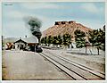
The old train station in Castle Rock (1917).
-
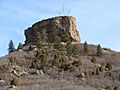
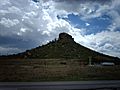
The town of Castle Rock is named after this prominent castle tower-shaped butte.
-
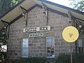
Castle Rock Museum (2010).
-
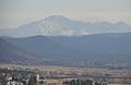
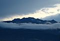
View of Pikes Peak from Rock Park in Castle Rock
-
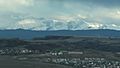
View of Devil's Head Lookout from Ridgeline Open Space in Castle Rock
-
View of Mount Blue Sky from Rock Park in Castle Rock
-
View from Rock Park Lookout Area in Castle Rock
-
View of Pikes Peak from I-25 in Castle Rock
-
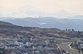
View of The Meadows neighborhood taken from Daniels Park
-
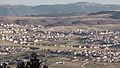
Castle Rock as seen from I-25
-
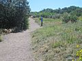
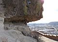
Hiking trail at Rock Park in Castle Rock


See also
 In Spanish: Castle Rock (Colorado) para niños
