Île Saint-Paul facts for kids
Quick facts for kids
Saint Paul Island
Île Saint-Paul (French)
|
|
|---|---|
|
Flag
|
|
|
Motto: "Liberté, égalité, fraternité"
|
|
|
Anthem: La Marseillaise
|
|

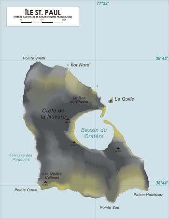
Map of Saint Paul Island.
|
|
| Status | District of French Southern and Antarctic Lands |
Saint Paul Island, also known as Île Saint-Paul, is a small island in the Indian Ocean. It's part of the French Southern and Antarctic Lands, often called TAAF. This island is about 6 square kilometers (2.3 square miles) in size.
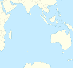
It is located far from other lands. It's about 90 kilometers (56 miles) south of the larger Île Amsterdam. It is also about 3000 kilometers (1864 miles) southeast of Réunion.
Saint Paul Island is a very important place for seabirds to raise their young. Scientists sometimes visit the island for short research trips. However, no one lives there permanently. A senior administrator on Réunion is in charge of the island.
Contents
Geography of Saint Paul Island
Saint Paul Island is a volcanic island shaped like a triangle. It is no more than 5 kilometers (3 miles) wide at its widest point. The island is actually the top of an active volcano. This volcano last erupted in 1793.
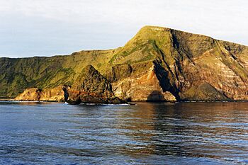
The island has rocky, steep cliffs on its east side. In 1780, a thin strip of rock that closed off the volcano's crater collapsed. This allowed the sea to flow into the crater through a 100-meter (328-foot) channel. Only very small ships can enter this channel.
The inside of the crater is a basin about 1 kilometer (0.6 miles) wide and 50 meters (164 feet) deep. It is surrounded by steep walls up to 270 meters (886 feet) high. There are also active thermal springs on the island.
Interestingly, Saint Paul Island is on the exact opposite side of the Earth from Cheyenne County, Colorado in the United States. This is one of the few places in the continental U.S. that has land directly opposite it, instead of ocean.
How Saint Paul Island Formed
The island sits on a large underwater area called the Amsterdam-Saint Paul Plateau. This plateau was formed by a volcanic hotspot. Scientists believe the active Amsterdam-Saint Paul hotspot is still close to the island.
Saint Paul Island is quite young, less than 400,000 years old. It was created by magma (molten rock) from the Earth's upper mantle and the hotspot plume.
History of Saint Paul Island
Saint Paul Island has a long and interesting history, with many explorers and visitors over the centuries.
Early Discoveries
The island was first discovered in 1559 by Portuguese sailors. It was carefully mapped and described by the crew of the ship São Paulo. Among them were Father Manuel Álvares and chemist Henrique Dias. They even correctly figured out the island's latitude.
The next confirmed sighting was by a Dutchman, Harwick Claesz de Hillegom, in 1618. Many other sightings happened throughout the 1600s. One of the first detailed descriptions and possibly the first landing was made in 1696 by Willem de Vlamingh.
19th Century Visits
In the 1800s, sailing ship captains sometimes used the island to check their navigation. Explorers, fishermen, and seal hunters also visited Saint Paul. For example, an American seal hunter named George William Robinson stayed on the island for 23 months, from 1819 to 1821. He returned in 1826 to collect more sealskins.
Seal hunting was common from 1789 to 1876. Records show 60 ships visited for sealing, and four of them were shipwrecked. You can still find ruins of old huts and inscriptions from this time.
France officially claimed the island in 1843. A captain named Mieroslawski, along with fishermen from Réunion, wanted to set up a fishery there. So, the Governor of Réunion declared that France owned Saint Paul and Île Amsterdam. The French flag was raised on Saint Paul on July 3, 1843. An inscribed rock from this time can still be seen on the edge of the crater lake. However, France gave up its claim in 1853, and all fishing operations stopped.
The first good map of the island was made in 1857. An Austrian ship, the Novara, sent a team to study the island's plants, animals, and geology.
In 1865, the Confederate warship, the CSS Shenandoah, briefly stopped at Saint Paul. Sailors explored the island and found two French fishermen. These fishermen told them they often didn't see anyone for six to eight months!

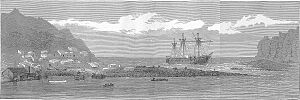
In 1871, a British troop transport ship, HMS Megaera, was wrecked on the island. Most of the 400 people on board had to stay there for over three months before being rescued.
In 1874, a French team spent three months on Saint Paul to observe the transit of Venus (when Venus passes in front of the Sun). A geologist named Charles Vélain used this chance to study the island's geology.
In 1889, Charles Lightoller was shipwrecked on the island for 88 days. He later became famous as the Second Officer of the RMS Titanic and survived its sinking. He wrote about his experience on Saint Paul in his autobiography. Lightoller even thought that pirates might have used the island and buried treasure in its caves!
In 1892 and 1893, French ships again claimed Saint Paul and Amsterdam Island for the French government.
20th Century Events
In 1928, a company tried to set up a spiny lobster cannery on Saint Paul. A group of workers stayed on the island to guard the equipment. They were supposed to be there for only a few months. But the ship to pick them up arrived much too late, in December 1930. Sadly, five people died from lack of food and scurvy. Only three survivors were rescued. This sad event is known as "the forgotten ones of St. Paul."
A few years later, in 1938, a French fishing boat crew got stranded on the island. Their distress calls were heard by chance 11,000 miles away in the United States! A 12-year-old amateur radio operator in California, Neil Taylor, even talked to the stranded crew and told them help was coming.
Island Environment
Saint Paul Island has a cool oceanic climate. The slopes of the volcano are covered in grass. It is a breeding ground for subantarctic fur seals, southern elephant seals, and rockhopper penguins.
In the past, the island was home to a unique flightless duck and several types of petrels. However, animals brought by humans, like black rats, house mice, European rabbits, pigs, and goats, harmed the native wildlife. The pigs and goats have since disappeared or been removed. In 1997, black rats were successfully removed from the island using poison baits.
Important Bird Area
Saint Paul Island and a nearby small rock called Quille Rock are recognized as an Important Bird Area (IBA) by BirdLife International. This means they are very important for breeding seabirds.
The island's location gives it a special mix of birds, different from colder subantarctic islands. Many rare breeding species live here. After the rats were removed, some birds, like MacGillivray's prions and great-winged petrels, started nesting on the main island again.
Other birds found here include about 9,000 pairs of northern rockhopper penguins. There are also sooty albatrosses, Indian yellow-nosed albatrosses, Australasian gannets, fairy prions, little and flesh-footed shearwaters, Wilson's storm petrels, and sooty terns. A painting from 1793 shows a duck on the island, but it's not clear if it was the same as the Amsterdam wigeon or a different kind. No specimens have been found to prove its existence.
See Also
- List of volcanoes in French Southern and Antarctic Lands
- Administrative divisions of France
- French overseas departments and territories
- Islands controlled by France in the Indian and Pacific oceans
- List of Antarctic and subantarctic islands
- Temperate grasslands, savannas, and shrublands
 | Roy Wilkins |
 | John Lewis |
 | Linda Carol Brown |


