North Fork Smoky Hill River facts for kids
Quick facts for kids North Fork Smoky Hill River |
|
|---|---|

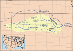
Map of the Smoky Hill drainage basin
|
|
| Country | United States |
| State | Colorado, Kansas |
| Physical characteristics | |
| Main source | Cheyenne County, Colorado 4,811 ft (1,466 m) 39°02′06″N 102°48′28″W / 39.03500°N 102.80778°W |
| River mouth | Smoky Hill River Logan County, Kansas 2,940 ft (900 m) 38°55′13″N 101°16′51″W / 38.92028°N 101.28083°W |
| Length | 195 mi (314 km) |
| Basin features | |
| Basin size | 759 sq mi (1,970 km2) |
| Watersheds | North Fork Smoky Hill-Smoky Hill-Kansas-Missouri-Mississippi |
The North Fork Smoky Hill River is a river in the central Great Plains of North America. It is a smaller stream that flows into the Smoky Hill River. This river starts in eastern Colorado and flows into western Kansas.
River's Journey
The North Fork Smoky Hill River begins in the High Plains area. This is a flat, high region of the Great Plains. The river's starting point, called its source, is in the very northern part of Cheyenne County, Colorado. This spot is about 29 miles (47 km) west-northwest of Cheyenne Wells.
From its source, the river flows east. Then it turns to flow east-northeast as it enters Kansas. In the southern part of Sherman County, a small lake has been made by building a dam across the river. This lake is called Sherman State Fishing Lake.
A few miles east of this lake, the river changes direction again. It turns southeast. It continues this path until it joins the Smoky Hill River. This meeting point, called a confluence, is in central Logan County. It is about 5 miles (8.0 km) west of Russell Springs.
The North Fork Smoky Hill River is about 195 miles (314 km) long. It drains an area of about 759 square miles (1,970 km2). This means it collects water from a large area around it.
How the River Gets Water
The North Fork Smoky Hill River is an intermittent river. This means it does not always have water flowing in it. Water only flows in the river during and right after it rains.
 | Tommie Smith |
 | Simone Manuel |
 | Shani Davis |
 | Simone Biles |
 | Alice Coachman |

