Harveyville, Kansas facts for kids
Quick facts for kids
Harveyville, Kansas
|
|
|---|---|

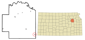
Location within Wabaunsee County and Kansas
|
|

|
|
| Country | United States |
| State | Kansas |
| County | Wabaunsee |
| Founded | 1880 |
| Incorporated | 1905 |
| Named for | Henry Harvey |
| Government | |
| • Type | Mayor–Council |
| Area | |
| • Total | 0.13 sq mi (0.33 km2) |
| • Land | 0.13 sq mi (0.33 km2) |
| • Water | 0.00 sq mi (0.00 km2) |
| Elevation | 1,168 ft (356 m) |
| Population
(2020)
|
|
| • Total | 178 |
| • Density | 1,370/sq mi (539/km2) |
| Time zone | UTC-6 (CST) |
| • Summer (DST) | UTC-5 (CDT) |
| ZIP code |
66431
|
| Area code | 785 |
| FIPS code | 20-30575 |
| GNIS ID | 2394319 |
Harveyville is a small city in Wabaunsee County, Kansas, United States. In 2020, about 178 people lived there. It is located about 8.5 miles (13.7 km) northwest of Burlingame.
Contents
History of Harveyville
Harveyville was started in 1880. It was named after Henry Harvey. He was a missionary who worked with the Shawnee Indians and early settlers in the area. The town officially became a city in 1905.
2012 Tornado: A Community's Strength
On February 28, 2012, a strong EF-2 tornado hit Harveyville around 9:02 pm. This tornado caused a lot of damage to the town. About 40% of the buildings in Harveyville were badly damaged. One of the town's two churches was completely destroyed.
Many homes were affected. Twenty-eight homes were so damaged they could not be lived in. Another 36 homes had moderate damage, and six had minor damage. One business building was also damaged. Twelve people were hurt, and sadly, one person died.
The National Weather Service studied the tornado. They found it was on the ground for 4 minutes. Its widest point was about 150 yards (137 meters) across. The tornado started about 1 mile (1.6 km) southwest of Harveyville and ended 4 miles (6.4 km) northeast of the town.
Geography and Climate
Harveyville is located in an area of Kansas called the Osage Cuestas. This region is part of the larger Great Plains.
The United States Census Bureau says that Harveyville covers a total area of about 0.13 square miles (0.33 square kilometers). All of this area is land.
Harveyville's Climate
The weather in Harveyville has hot and humid summers. Winters are usually mild to cool. According to the Köppen Climate Classification system, Harveyville has a humid subtropical climate. This type of climate is often shown as "Cfa" on climate maps.
Population and People
| Historical population | |||
|---|---|---|---|
| Census | Pop. | %± | |
| 1910 | 331 | — | |
| 1920 | 333 | 0.6% | |
| 1930 | 321 | −3.6% | |
| 1940 | 302 | −5.9% | |
| 1950 | 236 | −21.9% | |
| 1960 | 204 | −13.6% | |
| 1970 | 279 | 36.8% | |
| 1980 | 280 | 0.4% | |
| 1990 | 267 | −4.6% | |
| 2000 | 267 | 0.0% | |
| 2010 | 236 | −11.6% | |
| 2020 | 178 | −24.6% | |
| U.S. Decennial Census | |||
Harveyville is part of the larger Topeka Metropolitan Statistical Area. This means it's included in the area around the city of Topeka.
Population in 2020
The 2020 United States census counted 178 people living in Harveyville. There were 82 households and 47 families. Most of the people living there were white. About 5% of the population was Hispanic or Latino.
About 20.7% of households had children under 18. The average household had about 2.2 people. The average family had about 2.6 people. The median age in the city was 50.3 years old.
Population in 2010
In 2010, the census showed that 236 people lived in Harveyville. There were 93 households and 66 families. Most residents were white. About 2.1% of the population was Hispanic or Latino.
About 40.9% of households had children under 18. The average household size was 2.54 people. The average family size was 2.98 people. The median age in the city was 40 years. About 25.4% of residents were under 18 years old.
Fun Things to See
Harveyville is home to the Harveyville Project. This is a special place that has an Artist Residency and a Sculpture Garden. It's a great spot to see art!
Education for Students
The public schools in Harveyville are part of the Mission Valley USD 330 school district. This district was formed when schools from Eskridge, Harveyville, and Dover joined together. Mission Valley High School is located about 8 miles (12.9 km) northwest of Harveyville. The school's mascot is the Mission Valley Vikings.
Harveyville High School closed in 1970 when the schools combined. Before that, the Harveyville Yellow Jackets were very successful. In 1966, the boys' class BB Indoor Track & Field team won the Kansas State High School championship!
Getting Around Harveyville
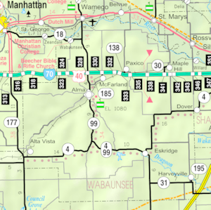
Highway K-31 runs along the south side of Harveyville. While the city is not far from the Kansas Turnpike, the closest exit is a bit further away. You would find it southwest along U.S. Route 56 in Lyon County.
See also
 In Spanish: Harveyville para niños

