McFarland, Kansas facts for kids
Quick facts for kids
McFarland, Kansas
|
|
|---|---|

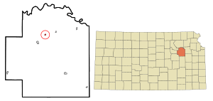
Location within Wabaunsee County and Kansas
|
|

|
|
| Country | United States |
| State | Kansas |
| County | Wabaunsee |
| Founded | 1887 |
| Incorporated | 1903 |
| Government | |
| • Type | Mayor–Council |
| Area | |
| • Total | 0.19 sq mi (0.48 km2) |
| • Land | 0.18 sq mi (0.46 km2) |
| • Water | 0.01 sq mi (0.02 km2) |
| Elevation | 1,020 ft (310 m) |
| Population
(2020)
|
|
| • Total | 272 |
| • Density | 1,430/sq mi (567/km2) |
| Time zone | UTC-6 (CST) |
| • Summer (DST) | UTC-5 (CDT) |
| ZIP code |
66501
|
| Area code | 785 |
| FIPS code | 20-43775 |
| GNIS ID | 2395066 |
McFarland is a small city in Wabaunsee County, Kansas, in the United States. It's a quiet place with a friendly community. In 2020, about 272 people lived there.
Contents
History of McFarland
McFarland was started in June 1887 by a person named S.H. Fairfield. It got its name from J. N. McFarland, who was a judge from Topeka, Kansas. He was also part of the company that helped create the town.
In 1887, a railroad called the Chicago, Kansas and Nebraska Railway built its main track right through McFarland. This track connected Topeka to Herington.
Over the years, the railroad changed hands many times. It was taken over by the Chicago, Rock Island and Pacific Railway, then the Oklahoma, Kansas and Texas Railroad, and finally the Union Pacific Railroad. Even today, many local people still call it the "Rock Island" railroad.
Around 1910, McFarland was a very busy place for trains. More than 30 passenger trains passed through the city every single day!
Geography and Climate
McFarland is a small city in terms of size. The United States Census Bureau says it covers about 0.19 square miles (0.48 square kilometers). Most of this area is land, with a tiny bit of water.
Understanding the Climate
The weather in McFarland has hot and humid summers. The winters are usually mild, meaning not too cold. This type of weather is called a humid subtropical climate. On climate maps, you might see it labeled as "Cfa."
Population and People
| Historical population | |||
|---|---|---|---|
| Census | Pop. | %± | |
| 1910 | 388 | — | |
| 1920 | 579 | 49.2% | |
| 1930 | 399 | −31.1% | |
| 1940 | 336 | −15.8% | |
| 1950 | 279 | −17.0% | |
| 1960 | 256 | −8.2% | |
| 1970 | 209 | −18.4% | |
| 1980 | 242 | 15.8% | |
| 1990 | 224 | −7.4% | |
| 2000 | 271 | 21.0% | |
| 2010 | 256 | −5.5% | |
| 2020 | 272 | 6.3% | |
| U.S. Decennial Census | |||
McFarland is part of the larger Topeka, Kansas area, which is called the Metropolitan Statistical Area. This means it's connected to the economy and community of Topeka.
Population in 2020
The 2020 United States census counted 272 people living in McFarland. There were 100 households, which are like homes or families living together. The average household had about 3 people.
About 29% of the people were under 18 years old. The median age was 33.5 years, which means half the people were younger than 33.5 and half were older.
Population in 2010
In the census of 2010, there were 256 people living in McFarland. There were 110 households. The average household size was about 2.33 people.
About 21.9% of the residents were under 18 years old. The median age in the city was 40.5 years.
Education for Students
The students in McFarland go to public schools managed by the Wabaunsee USD 329 school district. This district was created by combining schools from several towns, including Alma, Maple Hill, McFarland, and Paxico.
See also
 In Spanish: McFarland (Kansas) para niños
 | Stephanie Wilson |
 | Charles Bolden |
 | Ronald McNair |
 | Frederick D. Gregory |


