
Wabaunsee, Kansas facts for kids
Quick facts for kids
Wabaunsee, Kansas
|
|
|---|---|

Beecher Bible and Rifle Church, located at the southeast corner of Chapel and Elm Streets
|
|

|
|

Wabaunsee, Kansas
Location in Kansas

Wabaunsee, Kansas
Location in the United States
|
|
| Country | United States |
| State | Kansas |
| County | Wabaunsee |
| Township | Wabaunsee |
| Founded | 1855 |
| Named for | Chief Waubonsie |
| Elevation | 1,030 ft (310 m) |
| Population
(2020)
|
|
| • Total | 104 |
| Time zone | UTC-6 (CST) |
| • Summer (DST) | UTC-5 (CDT) |
| Area code | 785 |
| FIPS code | 20-74225 |
| GNIS ID | 476423 |
Wabaunsee is a small community in Wabaunsee County, Kansas, United States. It is called a census-designated place (CDP), which means it's an area identified by the U.S. Census Bureau for statistical purposes. In 2020, 104 people lived there. The town was named after Chief Wabaunsee, a leader of the Potawatomi people. Wabaunsee is also part of the larger Topeka, Kansas metropolitan area.
Contents
History of Wabaunsee: How It Began
Wabaunsee was started in 1855 by almost 100 people who moved there from New Haven, Connecticut. They were inspired by a speech from Henry Ward Beecher, a famous person who was against slavery. He even gave money to help the settlers buy rifles to protect themselves. These rifles were secretly sent through areas that supported slavery, hidden in boxes labeled "Beecher's Bibles."
Wabaunsee's Role in the Underground Railroad
Wabaunsee was strongly against slavery. It became a stop on the Underground Railroad in late 1856. The Underground Railroad was a secret network that helped enslaved people find freedom. Wabaunsee also helped the city of Lawrence after a big attack called Quantrill's Raid.
Building the Beecher Bible and Rifle Church
In 1862, the Beecher Bible and Rifle Church was finished. After the Civil War, people in Wabaunsee hoped a railroad would be built through their town. However, the railroad was built north of the river instead.
Wabaunsee as a County Seat
For a time, Wabaunsee was the main town, or "county seat," for the county. But after the Civil War, this role was moved to the town of Alma. Today, Wabaunsee has several homes and buildings, including the historic church. The church is listed on the National Register of Historic Places, which means it's an important historical site.
Geography: Where is Wabaunsee Located?
Wabaunsee is found about half a mile south of the Kansas River. It is in Wabaunsee Township. The community is located along K-18, about two miles west of K-99.
Education: Schools Serving Wabaunsee
The public schools for children in Wabaunsee are part of the Wamego USD 320 school district.
Transportation: Getting Around Wabaunsee
I-70 is a major highway about nine miles south of Wabaunsee. US-24 is another highway, three miles north in Wamego. Most of Wabaunsee is located on the south side of K-18. The local county government takes care of the streets in the community.
Images for kids
-
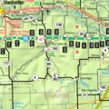
A map showing Wabaunsee County in Kansas.
