Rockville, Missouri facts for kids
Quick facts for kids
Rockville, Missouri
|
|
|---|---|

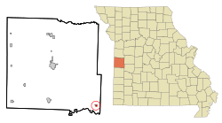
Location of Rockville, Missouri
|
|
| Country | United States |
| State | Missouri |
| County | Bates |
| Area | |
| • Total | 0.33 sq mi (0.85 km2) |
| • Land | 0.33 sq mi (0.85 km2) |
| • Water | 0.00 sq mi (0.00 km2) |
| Elevation | 771 ft (235 m) |
| Population
(2020)
|
|
| • Total | 135 |
| • Density | 410.33/sq mi (158.26/km2) |
| Time zone | UTC-6 (Central (CST)) |
| • Summer (DST) | UTC-5 (CDT) |
| ZIP code |
64780
|
| Area code(s) | 660 |
| FIPS code | 29-62786 |
| GNIS feature ID | 2396410 |
Rockville is a small city located in Bates County, Missouri, in the United States. It's also part of the larger Kansas City metropolitan area. In 2020, about 135 people lived there.
Contents
History of Rockville
Rockville was officially started in 1868. The city got its name from the white sandstone quarries nearby. A quarry is a place where stone is dug out of the ground.
A post office opened in Rockville in 1871. This means people could send and receive mail there.
Where is Rockville Located?
Rockville is found at coordinates 38°4′14″N 94°4′49″W / 38.07056°N 94.08028°W. This helps pinpoint its exact spot on a map.
The city covers about 0.33 square miles (0.85 square kilometers) of land. There is no water area within the city limits.
Rockville is in the southeast part of Bates County. It's about 18 miles (29 km) southeast of a city called Butler. The city is also on the north side of the Harry S Truman Reservoir, which is a large lake.
Another nearby town, Schell City, is about four miles (6.4 km) southwest of Rockville. It is located across the lake in Vernon County.
Who Lives in Rockville?
Population Changes Over Time
The number of people living in Rockville has changed quite a bit over the years. Here's a quick look at the population from different census counts:
| Historical population | |||
|---|---|---|---|
| Census | Pop. | %± | |
| 1880 | 315 | — | |
| 1890 | 554 | 75.9% | |
| 1900 | 580 | 4.7% | |
| 1910 | 566 | −2.4% | |
| 1920 | 486 | −14.1% | |
| 1930 | 408 | −16.0% | |
| 1940 | 336 | −17.6% | |
| 1950 | 372 | 10.7% | |
| 1960 | 255 | −31.5% | |
| 1970 | 203 | −20.4% | |
| 1980 | 281 | 38.4% | |
| 1990 | 193 | −31.3% | |
| 2000 | 162 | −16.1% | |
| 2010 | 166 | 2.5% | |
| 2020 | 135 | −18.7% | |
| U.S. Decennial Census | |||
Rockville's Population in 2010
According to the census from 2010, there were 166 people living in Rockville. These people lived in 72 different homes, and 38 of these were families.
The city had about 503 people per square mile (194 people per square kilometer). There were also 103 housing units, which means houses or apartments, in the city.
Most people in Rockville were White (95.8%). A small number were African American (0.6%), Asian (0.6%), or from two or more races (3.0%). About 2.4% of the population identified as Hispanic or Latino.
Households and Families
Out of the 72 homes in 2010:
- About 27.8% had children under 18 living there.
- 40.3% were married couples living together.
- 8.3% had a female head of the house with no husband present.
- 4.2% had a male head of the house with no wife present.
- 47.2% were not families (meaning people living alone or with roommates).
About 38.9% of all homes were made up of just one person. And 20.8% of these single-person homes had someone 65 years old or older living alone.
On average, there were 2.31 people in each home and 3.21 people in each family.
Age of Residents
The average age of people in Rockville in 2010 was 45 years old.
- 23.5% of residents were under 18 years old.
- 7.1% were between 18 and 24 years old.
- 19.2% were between 25 and 44 years old.
- 33.6% were between 45 and 64 years old.
- 16.3% were 65 years old or older.
When it came to gender, 48.8% of the people were male and 51.2% were female.
See also

- In Spanish: Rockville (Misuri) para niños
 | Frances Mary Albrier |
 | Whitney Young |
 | Muhammad Ali |

