
Bolivar, Missouri facts for kids
Quick facts for kids
Bolivar, Missouri
|
|
|---|---|

Polk County Courthouse, 2004
|
|

Location of Bolivar, Missouri
|
|
| Country | United States |
| State | Missouri |
| County | Polk |
| Area | |
| • Total | 8.24 sq mi (21.34 km2) |
| • Land | 8.22 sq mi (21.29 km2) |
| • Water | 0.02 sq mi (0.05 km2) |
| Elevation | 1,070 ft (330 m) |
| Population
(2020)
|
|
| • Total | 10,679 |
| • Density | 1,298.99/sq mi (501.57/km2) |
| Time zone | UTC-6 (Central (CST)) |
| • Summer (DST) | UTC-5 (CDT) |
| ZIP codes |
65613, 65727
|
| Area code(s) | 417 |
| FIPS code | 29-06976 |
| GNIS feature ID | 2394216 |
| Website | Bolivar, Missouri |
Bolivar is a city in Polk County, Missouri. It is also the main city, or county seat, of Polk County. Bolivar is located in the state of Missouri, in the United States.
Contents
History of Bolivar
Bolivar started as a small community around a place called Keeling Spring. Many of the first people who settled here came from Hardeman County, Tennessee. In 1833, this settlement became part of Greene County, Missouri.
Later, a new county called Polk County, Missouri was created. On November 10, 1835, the Polk County Court officially made the settlement a city. They named it Bolivar and chose it as the county seat. Bolivar became a "fourth-class city" on February 15, 1881.
Bolivar was an important stop on the Butterfield Overland Mail route between 1858 and 1861. This was a famous mail and passenger service. The town grew even more in 1884 when the St. Louis–San Francisco Railway train line reached it.
Why is it called Bolivar?
The name "Bolivar" was suggested by John Polk Campbell and his brothers. They named it after Bolivar, Tennessee, where their grandfather had lived. In the 1830s, the names Polk and Bolivar were linked to freedom and independence in the area. This means Bolivar, Missouri, is indirectly named after Simón Bolívar, a famous leader from South America.
Historic places in Bolivar
Several buildings in Bolivar are very old and important. They are listed on the National Register of Historic Places. These include the Bolivar Public Library, the First National Bank, and the North Ward School.
Geography and Climate
Bolivar is located in Marion Township. The city covers about 8.30 square miles (21.5 square kilometers). Most of this area is land, with only a small part being water.
Weather in Bolivar
Bolivar has a climate with warm summers and cool winters. The hottest month is usually July, and the coldest is January. The city gets a good amount of rain throughout the year.
| Climate data for Bolivar, Missouri (1991–2020 normals, extremes 1900–present) | |||||||||||||
|---|---|---|---|---|---|---|---|---|---|---|---|---|---|
| Month | Jan | Feb | Mar | Apr | May | Jun | Jul | Aug | Sep | Oct | Nov | Dec | Year |
| Record high °F (°C) | 77 (25) |
86 (30) |
90 (32) |
93 (34) |
100 (38) |
104 (40) |
115 (46) |
108 (42) |
108 (42) |
98 (37) |
87 (31) |
77 (25) |
115 (46) |
| Mean daily maximum °F (°C) | 42.8 (6.0) |
47.9 (8.8) |
57.5 (14.2) |
67.6 (19.8) |
75.9 (24.4) |
84.3 (29.1) |
89.1 (31.7) |
88.4 (31.3) |
81.0 (27.2) |
69.8 (21.0) |
57.1 (13.9) |
46.4 (8.0) |
67.3 (19.6) |
| Daily mean °F (°C) | 32.2 (0.1) |
36.6 (2.6) |
45.8 (7.7) |
55.5 (13.1) |
65.1 (18.4) |
73.7 (23.2) |
78.0 (25.6) |
76.8 (24.9) |
68.8 (20.4) |
57.1 (13.9) |
45.7 (7.6) |
36.1 (2.3) |
56.0 (13.3) |
| Mean daily minimum °F (°C) | 21.7 (−5.7) |
25.4 (−3.7) |
34.0 (1.1) |
43.5 (6.4) |
54.2 (12.3) |
63.0 (17.2) |
67.0 (19.4) |
65.2 (18.4) |
56.6 (13.7) |
44.5 (6.9) |
34.3 (1.3) |
25.7 (−3.5) |
44.6 (7.0) |
| Record low °F (°C) | −25 (−32) |
−19 (−28) |
−7 (−22) |
16 (−9) |
21 (−6) |
39 (4) |
44 (7) |
36 (2) |
19 (−7) |
17 (−8) |
−1 (−18) |
−19 (−28) |
−25 (−32) |
| Average precipitation inches (mm) | 2.31 (59) |
2.25 (57) |
3.59 (91) |
4.96 (126) |
5.90 (150) |
4.88 (124) |
4.62 (117) |
3.71 (94) |
4.25 (108) |
3.79 (96) |
3.42 (87) |
2.70 (69) |
46.38 (1,178) |
| Average precipitation days (≥ 0.01 in) | 7.7 | 7.7 | 10.5 | 11.0 | 12.7 | 10.7 | 8.5 | 7.6 | 7.8 | 9.3 | 8.8 | 7.4 | 109.7 |
| Source: NOAA | |||||||||||||
People of Bolivar
| Historical population | |||
|---|---|---|---|
| Census | Pop. | %± | |
| 1860 | 409 | — | |
| 1870 | 635 | 55.3% | |
| 1880 | 516 | −18.7% | |
| 1890 | 1,485 | 187.8% | |
| 1900 | 1,869 | 25.9% | |
| 1910 | 1,975 | 5.7% | |
| 1920 | 1,980 | 0.3% | |
| 1930 | 2,256 | 13.9% | |
| 1940 | 2,636 | 16.8% | |
| 1950 | 3,482 | 32.1% | |
| 1960 | 3,512 | 0.9% | |
| 1970 | 4,769 | 35.8% | |
| 1980 | 5,919 | 24.1% | |
| 1990 | 6,845 | 15.6% | |
| 2000 | 9,143 | 33.6% | |
| 2010 | 10,325 | 12.9% | |
| 2020 | 10,679 | 3.4% | |
| U.S. Decennial Census | |||
Bolivar is part of the larger Springfield, Missouri Metropolitan Area. This means it is connected to the economic and social life of Springfield.
Population in 2020
In 2020, the 2020 United States census counted 10,679 people living in Bolivar. There were 4,066 households, which are groups of people living together.
Most of the people in Bolivar are white (about 90%). There are also smaller groups of African-American, Native American, Asian, and other races. About 4% of the population is Hispanic or Latino.
About 23% of the people in Bolivar are under 18 years old. About 19% are 65 years old or older. The average age in the city was about 29.5 years.
Education in Bolivar

The Bolivar R-I School District runs several schools for students. These include:
- One primary school
- One intermediate school
- One middle school
- Bolivar High School
Bolivar is also home to Southwest Baptist University. This is a private university that has been open since 1879.
The city also has a public library, which is part of the Polk County Library system.
Media
The local newspaper in Bolivar is called the Bolivar Herald-Free Press.
Transportation
Bolivar has its own airport, the Bolivar Municipal Airport. It is located about 4 miles (6.4 km) east of the city center.
You can also travel to Bolivar by bus. Jefferson Lines provides bus service to the city.
Famous People from Bolivar
- John Blake: An Irish-American soldier and speaker.
- Mike Parson: He was the Lieutenant Governor of Missouri from 2017 to 2018, and then became the Governor of Missouri in 2018.
- Benjamin "Coach" Wade: He was a contestant on the TV show Survivor three times.
Images for kids
-
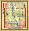
Butterfield Overland Mail Route from 1858-1861 on a map from 1873.

See also
 In Spanish: Bolivar (Misuri) para niños
