Hardeman County, Tennessee facts for kids
Quick facts for kids
Hardeman County
|
|
|---|---|

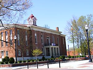
Hardeman County Courthouse in Bolivar
|
|

Location within the U.S. state of Tennessee
|
|
 Tennessee's location within the U.S. |
|
| Country | |
| State | |
| Founded | 1823 |
| Named for | Thomas J. Hardeman |
| Seat | Bolivar |
| Largest city | Bolivar |
| Area | |
| • Total | 670 sq mi (1,700 km2) |
| • Land | 668 sq mi (1,730 km2) |
| • Water | 2.6 sq mi (7 km2) 0.4%% |
| Population
(2020)
|
|
| • Total | 25,462 |
| • Density | 41/sq mi (16/km2) |
| Time zone | UTC−6 (Central) |
| • Summer (DST) | UTC−5 (CDT) |
| Congressional district | 8th |
Hardeman County is a special area in the state of Tennessee, USA. It's like a big neighborhood with its own local government. In 2020, about 25,462 people lived here. The main town and center of the county is Bolivar.
Contents
History of Hardeman County
Hardeman County was created in 1823 by the Tennessee General Assembly, which is like Tennessee's state parliament. It was formed from parts of another county, Hardin County, and some lands that belonged to Native American tribes.
Who Was Hardeman County Named After?
The county is named after a person named Thomas J. Hardeman (1788-1854). He was a brave soldier who fought in the Creek War and the War of 1812. He also played an important role in helping Texas become independent. Later, he served as a lawmaker in the Republic of Texas. His son, William Polk Hardeman, became a general during the American Civil War.
Early Settlers and New Towns
People started moving to this area in 1819. This happened after a special agreement, called a treaty, was signed with the Chickasaw people in 1818. This treaty allowed settlers to move into West Tennessee. Thomas Hardeman, who the county is named after, was one of the first settlers. Another important early settler was Ezekiel Polk, who was the grandfather of a future U.S. President, James K. Polk. More settlers came from other parts of Tennessee and nearby states like Alabama, North and South Carolina, and Virginia.
The very first permanent settlement was built in 1823 along the Hatchie River. It was called Hatchie Town. But because the town kept flooding from the river, people decided to move it about a mile south. This new location became the town of Bolivar.
Hardeman County During the Civil War
Hardeman County saw several battles and small fights during the American Civil War. The biggest battle was the Battle of Hatchie's Bridge on October 5, 1862. About 900 soldiers were hurt or killed in this battle. A large part of downtown Bolivar was also burned down during the war.
The town of Grand Junction in Hardeman County was special. It was the site of the first "contraband camp." This camp was set up by a man named John Eaton. It provided a safe place and jobs for enslaved people who had been freed or captured by the Union army during the war.
Correctional Facilities in the County
Hardeman County is home to two of Tennessee's four private prisons. These are the Whiteville Correctional Facility and the Hardeman County Correctional Center. They are both facilities for men and are managed by a company called Corrections Corporation of America.
Geography of Hardeman County
Hardeman County covers a total area of about 670 square miles. Most of this (about 668 square miles) is land, and a small part (about 2.6 square miles) is water. It is the fifth-largest county in Tennessee by size.
Neighboring Counties
Hardeman County shares its borders with several other counties:
- Madison County (north)
- Chester County (northeast)
- McNairy County (east)
- Alcorn County, Mississippi (southeast)
- Tippah County, Mississippi (south)
- Benton County, Mississippi (southwest)
- Fayette County (west)
- Haywood County (northwest)
Protected Natural Areas
The county has important natural areas that are protected:
- Hatchie National Wildlife Refuge: A place where wildlife, especially birds, can live safely.
- Chickasaw State Park (part): A state park offering outdoor activities.
Population and People
| Historical population | |||
|---|---|---|---|
| Census | Pop. | %± | |
| 1830 | 11,655 | — | |
| 1840 | 14,563 | 25.0% | |
| 1850 | 17,456 | 19.9% | |
| 1860 | 17,769 | 1.8% | |
| 1870 | 18,074 | 1.7% | |
| 1880 | 22,921 | 26.8% | |
| 1890 | 21,029 | −8.3% | |
| 1900 | 22,976 | 9.3% | |
| 1910 | 23,011 | 0.2% | |
| 1920 | 22,278 | −3.2% | |
| 1930 | 22,193 | −0.4% | |
| 1940 | 23,590 | 6.3% | |
| 1950 | 23,311 | −1.2% | |
| 1960 | 21,517 | −7.7% | |
| 1970 | 22,435 | 4.3% | |
| 1980 | 23,873 | 6.4% | |
| 1990 | 23,377 | −2.1% | |
| 2000 | 28,105 | 20.2% | |
| 2010 | 27,253 | −3.0% | |
| 2020 | 25,462 | −6.6% | |
| U.S. Decennial Census 1790-1960 1900-1990 1990-2000 2010-2014 |
|||
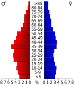
In 2020, the population of Hardeman County was 25,462 people. There were 8,891 households and 5,816 families living in the county.
Who Lives in Hardeman County?
Based on the 2010 census, here's a look at the different groups of people living in Hardeman County:
- About 56.1% were White (not Hispanic).
- About 41.01% were Black or African American.
- About 0.24% were Native American.
- About 0.29% were Asian.
- About 0.01% were Pacific Islander.
- About 0.2% were from other races.
- About 0.79% were from two or more races.
- About 0.96% of the population were Hispanic or Latino (who can be of any race).
Schools in Hardeman County
Hardeman County has several schools for students of all ages:
- Bolivar Central High School
- Bolivar Middle School
- Bolivar Elementary School
- Whiteville Elementary School
- Middleton High School
- Middleton Elementary School
- Toone Elementary School
- Grand Junction Elementary School
- Hornsby Elementary School
Communities in Hardeman County
Hardeman County has several towns and cities, as well as smaller communities.
Cities in Hardeman County
- Bolivar: This is the county seat and the largest city.
- Grand Junction: Part of this city is in Hardeman County.
- Middleton
- Medon: Most of this city is in Madison County.
Towns in Hardeman County
- Hickory Valley
- Hornsby: Part of this town is in McNairy County.
- Saulsbury
- Silerton: Part of this town is in Hardeman County.
- Toone
- Whiteville
Other Communities
These are smaller, unincorporated communities or historic places in the county:
- Cloverport
- Essary Springs
- Middleburg
- New Castle
- Piney Grove
- Porters Creek
- Pocahontas
- Rogers Springs
- Serles
- Van Buren
- Vildo
Images for kids
See also
 In Spanish: Condado de Hardeman (Tennessee) para niños
 | Audre Lorde |
 | John Berry Meachum |
 | Ferdinand Lee Barnett |


