Toone, Tennessee facts for kids
Quick facts for kids
Toone, Tennessee
|
|
|---|---|

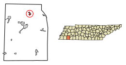
Location of Toone in Hardeman County, Tennessee
|
|
| Country | United States |
| State | Tennessee |
| County | Hardeman |
| Established | 1856 |
| Incorporated | 1903 |
| Named for | James Toone (early settler) |
| Area | |
| • Total | 1.07 sq mi (2.79 km2) |
| • Land | 1.07 sq mi (2.79 km2) |
| • Water | 0.00 sq mi (0.00 km2) |
| Elevation | 410 ft (125 m) |
| Population
(2020)
|
|
| • Total | 270 |
| • Density | 251.16/sq mi (96.94/km2) |
| Time zone | UTC-6 (Central (CST)) |
| • Summer (DST) | UTC-5 (CDT) |
| ZIP code |
38381
|
| Area code(s) | 731 |
| FIPS code | 47-74640 |
| GNIS feature ID | 1304137 |
Toone is a small town located in Hardeman County, Tennessee, in the United States. In 2020, about 270 people lived there.
Contents
History of Toone
Toone is in an area that was once home to the Chickasaw people. The first Europeans came to this area around 1725. They traveled on flatboats along the Hatchie River.
By 1830, enough people lived in Toone for it to be counted in the United States census. In 1856, Toone became a railroad town. This meant that businesses grew around the new railroad.
Making bricks became a very important industry in Toone. Many old homes in the town still have bricks made right there in Toone. During the Civil War, the Union Army used the town as a camp. There was also a small fight here over control of the railroad tracks.
Where is Toone?
Toone is located in the northern part of Hardeman County. You can find it at coordinates 35°21′8″N 88°57′14″W / 35.35222°N 88.95389°W.
Tennessee State Route 138 (SR 138) is the main road through town, called Main Street. This road goes northwest about 21 miles (34 km) to Interstate 40. It goes southeast about 2 miles (3.2 km) to SR 18. Bolivar, which is the county seat of Hardeman County, is 8 miles (13 km) south of Toone.
SR 100 also runs through a northern part of Toone. It goes east about 19 miles (31 km) to Henderson. It goes west about 11 miles (18 km) to Whiteville.
The United States Census Bureau says that Toone covers about 1.07 square miles (2.7 km2) of land. There is no water area within the town limits. Pugh Creek flows through the southern part of Toone. It then flows southwest into Mill Creek and the Hatchie River.
Toone's Population Over Time
| Historical population | |||
|---|---|---|---|
| Census | Pop. | %± | |
| 1880 | 196 | — | |
| 1890 | 254 | 29.6% | |
| 1900 | 241 | −5.1% | |
| 1910 | 245 | 1.7% | |
| 1920 | 294 | 20.0% | |
| 1930 | 296 | 0.7% | |
| 1940 | 305 | 3.0% | |
| 1950 | 231 | −24.3% | |
| 1960 | 202 | −12.6% | |
| 1970 | 200 | −1.0% | |
| 1980 | 355 | 77.5% | |
| 1990 | 279 | −21.4% | |
| 2000 | 330 | 18.3% | |
| 2010 | 364 | 10.3% | |
| 2020 | 270 | −25.8% | |
| Sources: | |||
In 2000, there were 330 people living in Toone. There were 107 households and 80 families. About 35.5% of households had children under 18 years old.
The population was spread out by age. About 23.3% were under 18. About 17.6% were 65 years or older. The average age in the town was 40 years old.
Economy in Toone
Toone has a bank and a post office in its downtown area.
The Kilgore Flare Company is an important business near Toone. This company has been operating there since the early 1920s. They make special flares that are used by U.S. military aircraft. These flares are designed to trick enemy missiles.
The company's facility covers about 264 acres (1.07 km2) on the edge of town. They also have another 242-acre (0.98 km2) area nearby for testing their products.
Images for kids
See also
 In Spanish: Toone (Tennessee) para niños
 | Charles R. Drew |
 | Benjamin Banneker |
 | Jane C. Wright |
 | Roger Arliner Young |


