Whiteville, Tennessee facts for kids
Quick facts for kids
Whiteville, Tennessee
|
|
|---|---|

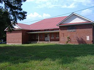
The former Allen-White School in Whiteville, August 2010
|
|
| Motto(s):
"Gateway to Hardeman County"
|
|

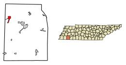
Location of Whiteville in Hardeman County, Tennessee
|
|
| Country | United States |
| State | Tennessee |
| County | Hardeman |
| Settled | c. 1800 |
| Incorporated | 1901 |
| Named for | Dr. John White, early settler |
| Area | |
| • Total | 2.64 sq mi (6.83 km2) |
| • Land | 2.64 sq mi (6.83 km2) |
| • Water | 0.00 sq mi (0.00 km2) |
| Elevation | 492 ft (150 m) |
| Population
(2020)
|
|
| • Total | 2,606 |
| • Density | 988.62/sq mi (381.65/km2) |
| Time zone | UTC−6 (Central (CST)) |
| • Summer (DST) | UTC−5 (CDT) |
| ZIP Code |
38075
|
| Area code(s) | 731, 901 |
| FIPS code | 47-80540 |
| GNIS feature ID | 1274472 |
Whiteville is a town located in Hardeman County, Tennessee, United States. In 2020, the town had a population of 2,606 people. However, the official count was later updated to 4,564 in 2023.
Whiteville is known for being home to two privately run prisons. It also has the historic Allen-White School, which was once a Rosenwald School. This school was added to the National Register of Historic Places in 2005.
The town of Whiteville started as a trading post around the early 1800s. It officially became a town in 1901. Its economy grew mainly because of cotton farming.
Contents
Where is Whiteville Located?
Whiteville is in the northwestern part of Hardeman County. It sits at coordinates 35.324496 degrees North and -89.145721 degrees West.
Major Roads and Nearby Cities
U.S. Route 64 passes through the southern part of Whiteville. This road leads southeast about 11 miles to Bolivar, which is the main town of the county. It also goes southwest about 13 miles to Somerville.
Tennessee State Route 100 goes east from Whiteville for about 30 miles to Henderson. State Route 179 travels north from the center of Whiteville about 15 miles to Interstate 40.
Land and Water Features
According to the United States Census Bureau, Whiteville covers a total area of about 7.1 square kilometers (2.7 square miles). All of this area is land. The town's water drains into the beginnings of Hickory Creek. This creek then flows north into the Hatchie River.
How Many People Live in Whiteville?
The number of people living in Whiteville has changed over the years. Here is a look at the population counts from different years:
| Historical population | |||
|---|---|---|---|
| Census | Pop. | %± | |
| 1860 | 186 | — | |
| 1870 | 80 | −57.0% | |
| 1880 | 116 | 45.0% | |
| 1890 | 209 | 80.2% | |
| 1900 | 463 | 121.5% | |
| 1910 | 741 | 60.0% | |
| 1920 | 749 | 1.1% | |
| 1930 | 692 | −7.6% | |
| 1940 | 796 | 15.0% | |
| 1950 | 794 | −0.3% | |
| 1960 | 757 | −4.7% | |
| 1970 | 992 | 31.0% | |
| 1980 | 1,270 | 28.0% | |
| 1990 | 1,050 | −17.3% | |
| 2000 | 3,148 | 199.8% | |
| 2010 | 4,638 | 47.3% | |
| 2020 | 2,606 | −43.8% | |
| Sources: | |||
Understanding the 2020 Census Results
The first count from the 2020 United States census showed 2,606 people living in Whiteville. This count included 289 households and 203 families. However, this first count did not include the people living in the town's two prisons.
Because of this, the town asked for the numbers to be checked again. In 2023, the Census Bureau released updated numbers. The new population count for Whiteville was increased to 4,564 people.
What is the Racial Makeup of Whiteville?
The table below shows the different racial groups living in Whiteville based on the 2020 census.
| Race | Num. | Perc. |
|---|---|---|
| White (non-Hispanic) | 1,019 | 38.49% |
| Black or African American (non-Hispanic) | 1,480 | 56.45% |
| Native American | 4 | 0.15% |
| Asian | 5 | 0.19% |
| Other/Mixed | 50 | 1.92% |
| Hispanic or Latino | 73 | 2.8% |
Educational Opportunities in Whiteville
The Tennessee Colleges of Applied Technology has a campus located in Whiteville. These colleges offer hands-on training for different jobs.
Who are Some Famous People from Whiteville?
Many notable people have connections to Whiteville, Tennessee.
- Benjamin Elton Cox: A well-known civil rights activist.
- Walter F. Lineberger: He served as a Representative for the United States.
- Calvin Newborn: A talented jazz guitarist.
- Phineas Newborn Jr.: A famous jazz pianist.
Images for kids
See also
 In Spanish: Whiteville (Tennessee) para niños
 | Anna J. Cooper |
 | Mary McLeod Bethune |
 | Lillie Mae Bradford |


