
McNairy County, Tennessee facts for kids
Quick facts for kids
McNairy County
|
|||
|---|---|---|---|

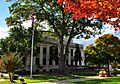
McNairy County Courthouse in Selmer
|
|||
|
|||

Location within the U.S. state of Tennessee
|
|||
 Tennessee's location within the U.S. |
|||
| Country | |||
| State | |||
| Founded | October 8, 1823 | ||
| Named for | John McNairy | ||
| Seat | Selmer | ||
| Largest city | Selmer | ||
| Area | |||
| • Total | 564 sq mi (1,460 km2) | ||
| • Land | 563 sq mi (1,460 km2) | ||
| • Water | 0.8 sq mi (2 km2) 0.1%% | ||
| Population
(2020)
|
|||
| • Total | 25,866 |
||
| • Density | 46/sq mi (18/km2) | ||
| Time zone | UTC−6 (Central) | ||
| • Summer (DST) | UTC−5 (CDT) | ||
| Congressional district | 8th | ||


McNairy County is a county located in the state of Tennessee. In 2020, about 25,866 people lived there. The main town and largest city is Selmer. McNairy County is right on Tennessee's border with Mississippi.
This county is famous for a few things! Buford Pusser, a sheriff whose story was made into the Walking Tall movies, worked here. It's also home to the Coon Creek Science Center, a cool place where you can find fossils of ancient sea creatures like mosasaurs.
Music history is also important here. Famous disc jockey Dewey Phillips was from Adamsville. And Carl Perkins made his first recordings in Eastview. He even met Elvis Presley for the first time at a show in Bethel Springs, Tennessee.
Contents
History of McNairy County

McNairy County was created in 1823. It was formed from parts of Hardin County. The county was named after Judge John McNairy.
For many years, Purdy was the main town, or county seat, of McNairy County. But in 1890, Selmer became the new county seat. It has been the county seat ever since.
During the American Civil War, McNairy County was a place with mixed feelings. Some people supported the Southern states that wanted to leave the United States. Others wanted to stay part of the Union.
Sheriff Buford Pusser's Story
Buford Pusser was the sheriff of McNairy County from 1964 to 1970. His office was at the courthouse and jail in Selmer. He became well-known for fighting against illegal activities and corruption in the county. His life story has been told in the Walking Tall movies. These movies have starred actors like Joe Don Baker and Dwayne Johnson.
Newspapers in McNairy County
The oldest business still running in McNairy County is its newspaper, the Independent Appeal. It started in 1902 as the McNairy County Independent. You can find it in Selmer.
In 2008, a new weekly newspaper called The McNairy County News was started. It was created by Tom Evans, who used to work for the Independent Appeal.
McNairy County Schools
The schools in McNairy County are part of the McNairy County School District. The superintendent is Greg Martin. This is a public school district. It teaches students from kindergarten all the way through twelfth grade. The district has 8 schools and serves over 4,000 students.
Schools in the District
- Elementary Schools
- Adamsville Elementary School
- Bethel Springs Elementary School
- Michie Elementary School
- Ramer Elementary School
- Selmer Elementary School
- Middle Schools
- Selmer Middle School
- High Schools
- Adamsville High School
- McNairy Central High School
School Board
The school district has a board of education. This board has 7 members. Each member is chosen from one of the 7 areas, or districts, that make up McNairy County.
Geography of McNairy County
McNairy County covers about 564 square miles. Most of this area is land, with only a small part being water.
Two major highways cross through McNairy County: U.S. Route 64 (which goes east-west) and U.S. Route 45 (which goes north-south). They meet in Selmer. These highways make it easy to travel to and from the county. Route 64 is also part of the historic Lee Highway, which used to stretch across the country.
Other important roads include Tennessee State Route 22 and Tennessee State Route 57. These state highways also help people get around the county.
Neighboring Counties
McNairy County shares borders with these other counties:
- Chester County (to the north)
- Hardin County (to the east)
- Alcorn County, Mississippi (to the south)
- Hardeman County (to the west)
Protected Natural Areas
- Big Hill Pond State Park is a state park located in McNairy County.
Population Information
| Historical population | |||
|---|---|---|---|
| Census | Pop. | %± | |
| 1830 | 5,697 | — | |
| 1840 | 9,385 | 64.7% | |
| 1850 | 12,864 | 37.1% | |
| 1860 | 14,732 | 14.5% | |
| 1870 | 12,726 | −13.6% | |
| 1880 | 17,271 | 35.7% | |
| 1890 | 15,510 | −10.2% | |
| 1900 | 17,760 | 14.5% | |
| 1910 | 16,536 | −6.9% | |
| 1920 | 18,350 | 11.0% | |
| 1930 | 19,901 | 8.5% | |
| 1940 | 20,424 | 2.6% | |
| 1950 | 20,390 | −0.2% | |
| 1960 | 18,085 | −11.3% | |
| 1970 | 18,369 | 1.6% | |
| 1980 | 22,525 | 22.6% | |
| 1990 | 22,422 | −0.5% | |
| 2000 | 24,653 | 10.0% | |
| 2010 | 26,075 | 5.8% | |
| 2020 | 25,866 | −0.8% | |
| U.S. Decennial Census 1790-1960 1900-1990 1990-2000 2010-2014 |
|||

In 2020, there were 25,866 people living in McNairy County. There were about 10,022 households and 6,724 families.
Parks and Fun Places
McNairy County is home to Big Hill Pond State Park. This park is huge, covering about 5,000 acres. It has lots of trees and forests.
The county also has the Coon Creek Science Center. This is a special place for finding fossils! It's located in Leapwood. The fossils found here are from about 70 million years ago. They include shells and bones of sea animals like mosasaurs.
Communities in McNairy County
Here are some of the towns and cities you can find in McNairy County:
Cities
- Adamsville (partly in Hardin County)
- Bethel Springs
- Ramer
- Selmer (This is the county seat and the biggest city!)
Towns
- Eastview
- Finger
- Guys
- Hornsby (mostly in Hardeman County)
- Milledgeville (part of it)
- Michie
- Stantonville
Small Communities (Unincorporated)
- Acton
- Chewalla
- Falcon (a neighborhood in Selmer)
- Leapwood
- McNairy
- Purdy
- Pocahontas (mostly in Hardeman County)
Images for kids
-

Flag of McNairy County
-

Seal of McNairy County
-
McNairy County Courthouse in Selmer
See also
 In Spanish: Condado de McNairy para niños
