Hornsby, Tennessee facts for kids
Quick facts for kids
Hornsby, Tennessee
|
|
|---|---|

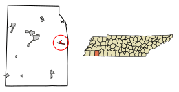
Location of Hornsby in Hardeman County, Tennessee.
|
|
| Country | United States |
| State | Tennessee |
| County | Hardeman, McNairy |
| Chartered | 1920 |
| Area | |
| • Total | 1.05 sq mi (2.72 km2) |
| • Land | 1.05 sq mi (2.72 km2) |
| • Water | 0.00 sq mi (0.00 km2) |
| Elevation | 381 ft (116 m) |
| Population
(2020)
|
|
| • Total | 264 |
| • Density | 250.95/sq mi (96.93/km2) |
| Time zone | UTC-6 (Central (CST)) |
| • Summer (DST) | UTC-5 (CDT) |
| ZIP code |
38044
|
| Area code(s) | 731 |
| FIPS code | 47-36080 |
| GNIS feature ID | 1288378 |
Hornsby is a small town located in Hardeman County and McNairy County in the state of Tennessee. In 2010, about 303 people lived there. You can find Hornsby just east of Bolivar, right along U.S. Highway 64.
Contents
History of Hornsby
Before 1820, a man named Dr. Daniel Smith Webb started a gristmill (a mill for grinding grain) and a sawmill near the Little Hatchie River. This area became known as Webb's Mill. In the 1820s, two veterans from the American Revolutionary War, Joel and William Crain, moved there. They created a port and a place to get supplies close to Webb's Mill.
This growing area eventually had two churches, a subscription school (where parents paid for their children to attend), a stagecoach stop, and an inn. It was a busy spot between Bolivar and Purdy. People started calling this new settlement Crainville.
In the early 1900s, Crainville became a railroad town. The Gulf, Mobile and Northern Railroad built a new train station on a farm owned by Kimborough Hornsby. In 1915, a special type of well called an artesian well was dug near the station. This was the first of its kind in the United States!
On October 16, 1920, Hornsby officially became a town with its own government. The first house was built by Finley Holyfield in 1919. By 1923, the town was famous for its many wells and was even called "the village of artesian wells," with nine in total. In 1971, a tornado caused some damage to homes in Hornsby. Today, you can still see some old homes from the early 1900s. The remains of Crainville are also visible just east of town.
Geography of Hornsby
Hornsby is located at 35°13′36″N 88°49′47″W / 35.22667°N 88.82972°W. According to the United States Census Bureau, the town covers an area of about 1.3 square miles (3.4 square kilometers). All of this area is land.
People of Hornsby
| Historical population | |||
|---|---|---|---|
| Census | Pop. | %± | |
| 1930 | 219 | — | |
| 1940 | 207 | −5.5% | |
| 1950 | 280 | 35.3% | |
| 1960 | 228 | −18.6% | |
| 1970 | 212 | −7.0% | |
| 1980 | 401 | 89.2% | |
| 1990 | 313 | −21.9% | |
| 2000 | 306 | −2.2% | |
| 2010 | 303 | −1.0% | |
| 2020 | 264 | −12.9% | |
| Sources: | |||
In the year 2000, there were 306 people living in Hornsby. These people made up 123 households, with 94 of them being families. The town had about 243 people per square mile. Most of the people living in Hornsby were White.
About 36% of the households had children under 18 years old. More than half of the households (57%) were married couples living together. The average household had about 2.5 people.
The median age of people in Hornsby was 38 years old. About 25.5% of the population was under 18. Around 16% of the people were 65 years or older.
Things to See in Hornsby
Hornsby was once well-known for its artesian well. This special well was located at the old Whitehurst Motor Company. It closed to the public in the 1960s. However, one of the original nine wells is still open for visitors! This well is over 100 years old and can be found at Hornsby Elementary School.
Education in Hornsby
The town of Hornsby has one school for younger students: Hornsby Elementary School.
See also
 In Spanish: Hornsby (Tennessee) para niños
 | May Edward Chinn |
 | Rebecca Cole |
 | Alexa Canady |
 | Dorothy Lavinia Brown |

