Fayette County, Tennessee facts for kids
Quick facts for kids
Fayette County
|
||
|---|---|---|

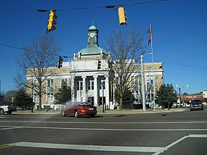
Fayette County Courthouse in Somerville
|
||
|
||

Location within the U.S. state of Tennessee
|
||
 Tennessee's location within the U.S. |
||
| Country | ||
| State | ||
| Founded | September 29, 1824 | |
| Named for | Marquis de Lafayette | |
| Seat | Somerville | |
| Largest town | Oakland | |
| Area | ||
| • Total | 706 sq mi (1,830 km2) | |
| • Land | 705 sq mi (1,830 km2) | |
| • Water | 1.5 sq mi (4 km2) 0.2%% | |
| Population
(2020)
|
||
| • Total | 41,990 |
|
| • Density | 56.8/sq mi (21.9/km2) | |
| Time zone | UTC−6 (Central) | |
| • Summer (DST) | UTC−5 (CDT) | |
| Congressional district | 8th | |
Fayette County is a county in the state of Tennessee, USA. In 2020, about 41,990 people lived there. The main town, or county seat, is Somerville. The county got its name from the Marquis de la Fayette, a French hero who helped America during the American Revolution.
Fayette County is part of the larger Memphis city area. It has a culture similar to the Mississippi Delta region. In the 1800s, it was a big area for cotton farms that relied on the forced labor of enslaved people.
Contents
History of Fayette County
Fayette County was created in 1824 by the Tennessee General Assembly. It was formed from parts of nearby Shelby and Hardeman counties. In the same year, Somerville was chosen as the county seat. The first churches in the county were the First Presbyterian Church in Somerville (started in 1829) and Immanuel Parish (started in 1832).
A famous person from Somerville, Tennessee was Herb Parsons (1908–1959). He was known as Winchester's "Showman Shooter" for 30 years, showing off amazing shooting skills.
After slavery ended, many African-American residents in Fayette County became sharecroppers. This meant they farmed land owned by others and paid rent with a share of their crops. In the 1960s and 1970s, people working for civil rights fought for equal rights. They wanted schools to be open to everyone, no matter their race. They also worked to make sure all citizens could vote. Some tenant farmers who tried to register to vote were forced off their land. They had to live in "tent cities" for a while.
In recent years, Fayette County has been changing. It's becoming more like a suburban area as people move there from the bigger city of Memphis.
Geography of Fayette County
Fayette County covers about 706 square miles. Most of this (705 square miles) is land, and a small part (1.5 square miles) is water. It is the third-largest county in Tennessee by area. It's about the same size as Marshall County in Mississippi.
Counties Nearby
- Haywood County (north)
- Hardeman County (east)
- Benton County, Mississippi (southeast)
- Marshall County, Mississippi (south)
- Shelby County (west)
- Tipton County (northwest)
Protected Natural Areas
- William B. Clark Conservation Area
- Ghost River State Natural Area
- Piperton Wetland Complex Wildlife Management Area (part)
- Wolf River Wildlife Management Area
- WMA Briggs Tract
- Herb Parsons Lake
People and Population (Demographics)
| Historical population | |||
|---|---|---|---|
| Census | Pop. | %± | |
| 1830 | 8,652 | — | |
| 1840 | 21,501 | 148.5% | |
| 1850 | 26,719 | 24.3% | |
| 1860 | 24,327 | −9.0% | |
| 1870 | 26,145 | 7.5% | |
| 1880 | 31,871 | 21.9% | |
| 1890 | 28,878 | −9.4% | |
| 1900 | 29,701 | 2.8% | |
| 1910 | 30,257 | 1.9% | |
| 1920 | 31,499 | 4.1% | |
| 1930 | 28,891 | −8.3% | |
| 1940 | 30,322 | 5.0% | |
| 1950 | 27,535 | −9.2% | |
| 1960 | 24,577 | −10.7% | |
| 1970 | 22,692 | −7.7% | |
| 1980 | 25,305 | 11.5% | |
| 1990 | 25,559 | 1.0% | |
| 2000 | 28,806 | 12.7% | |
| 2010 | 38,413 | 33.4% | |
| 2020 | 41,990 | 9.3% | |
| U.S. Decennial Census 1790–1960 1900–1990 1990–2000 2010–2014 2017 |
|||
Since the early 1990s, the western part of Fayette County has grown a lot. This happened after a major highway was expanded. Even though Somerville is still the county seat, the town of Oakland has grown much larger. Many people who work in nearby Shelby County choose to live in Oakland because housing is more affordable there.
Even with this growth, farming is still very important to Fayette County's economy. Historically, it was known for its cotton farms. Some of the biggest farmers in the county come from families who have farmed for many generations. Other farmers are newer but have built successful farming businesses.
Fayette County has become a popular place for people from the Memphis area to move. In 2007, the value of new building permits in Fayette County was almost as high as in much larger suburban areas like DeSoto County, Mississippi.
2020 Census Information
The 2020 United States census counted 41,990 people living in Fayette County. There were 15,596 households and 11,567 families.
| Race | Num. | Perc. |
|---|---|---|
| White (non-Hispanic) | 27,558 | 65.63% |
| Black or African American (non-Hispanic) | 11,038 | 26.29% |
| Native American | 59 | 0.14% |
| Asian | 269 | 0.64% |
| Pacific Islander | 18 | 0.04% |
| Other/Mixed | 1,618 | 3.85% |
| Hispanic or Latino | 1,430 | 3.41% |
2010 Census Information
In the 2010 census, there were 38,413 people living in Fayette County. The population density was about 54 people per square mile.
The racial makeup of the county was:
- 69.19% White
- 28.07% Black or African American
- 0.48% Asian
- 0.28% Native American
- 0.01% Pacific Islander
- 1.08% from other races
- 0.89% from two or more races
About 2.23% of the people were of Hispanic or Latino background.
There were 14,505 households. About 32.58% of these households had children under 18. Most households (58.24%) were married couples living together.
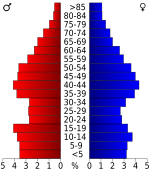
The median age in the county was 41.9 years. About 23.11% of residents were under 18, and 14.88% were 65 or older. Slightly more than half (50.42%) of the residents were female.
The average household income was $57,919, and the average family income was $68,159. The per capita income (income per person) was $30,471. About 14.4% of the total population lived below the poverty line. This included 22.1% of those under 18 and 9.8% of those 65 and older.
Education
Fayette County has several schools for students of different ages. There is also a university campus.
- Fayette Ware Comprehensive High
- Fayette Academy (a private school for grades PK-12)
- Fayette Christian School
- Rossville Christian Academy
- West Jr High
- East Jr High
- Buckley-Carpenter Elementary School
- Southwest Elementary
- Oakland Elementary
- LaGrange-Moscow Elementary
- University of Tennessee at Martin (Somerville Campus)
Communities in Fayette County
Fayette County has several cities, towns, and smaller unincorporated communities.
Cities
- Gallaway
- Grand Junction (mostly in Hardeman County)
- Moscow
- Piperton
- Williston
Towns
- Braden
- La Grange
- Oakland
- Rossville
- Somerville (county seat)
Unincorporated Communities
See also
 In Spanish: Condado de Fayette (Tennessee) para niños
 | Dorothy Vaughan |
 | Charles Henry Turner |
 | Hildrus Poindexter |
 | Henry Cecil McBay |


