Marshall County, Mississippi facts for kids
Quick facts for kids
Marshall County
|
|
|---|---|

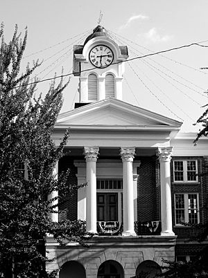
The Marshall County courthouse in Holly Springs
|
|

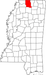
Location within the U.S. state of Mississippi
|
|
 Mississippi's location within the U.S. |
|
| Country | |
| State | |
| Founded | 1836 |
| Named for | John Marshall |
| Seat | Holly Springs |
| Largest city | Holly Springs |
| Area | |
| • Total | 710 sq mi (1,800 km2) |
| • Land | 706 sq mi (1,830 km2) |
| • Water | 3.6 sq mi (9 km2) 0.5%% |
| Population
(2020)
|
|
| • Total | 33,752 |
| • Estimate
(2023)
|
34,123 |
| • Density | 47.5/sq mi (18.35/km2) |
| Time zone | UTC−6 (Central) |
| • Summer (DST) | UTC−5 (CDT) |
| Congressional district | 1st |
Marshall County is a special area called a county in the northern part of Mississippi, a state in the United States. It's located right on the border! In 2020, about 33,752 people lived here. The main town and where the county government is located is Holly Springs. The county is named after John Marshall, who was a very important judge in the early 1800s. Marshall County is also part of the larger Memphis city area, which includes parts of Tennessee, Mississippi, and Arkansas.
Contents
Geography
Marshall County covers a total area of about 710 square miles. Most of this area, about 706 square miles, is land. Only a small part, about 3.6 square miles, is water. That's less than 1% of the total area!
Major roads
Many important roads pass through Marshall County, helping people travel and connect different places.
 Interstate 22
 Interstate 269
 U.S. Route 72
 U.S. Route 78
 Mississippi Highway 4
 Mississippi Highway 7
 Mississippi Highway 178
 Mississippi Highway 302
 Mississippi Highway 309
 Mississippi Highway 310
 Mississippi Highway 311
 Mississippi Highway 349
Neighboring counties
Marshall County shares its borders with several other counties.
- Fayette County, Tennessee (to the north)
- Benton County (to the east)
- Union County (to the southeast)
- Lafayette County (to the south)
- Tate County (to the southwest)
- DeSoto County (to the west)
- Shelby County, Tennessee (to the northwest)
Protected natural areas
Part of the Holly Springs National Forest is located within Marshall County. This is a special area where nature is protected.
People and population
In 2020, the census showed that 33,752 people lived in Marshall County. There were 12,772 households and 8,832 families.
Most people in Marshall County are either White or Black or African American. In 2020, about 48.25% of the people were White, and about 44.09% were Black or African American. There are also people from other backgrounds, including Hispanic or Latino people, who made up about 4.56% of the population.
Communities
Marshall County has several towns and communities where people live.
City
- Holly Springs is the biggest town and the county seat. This means it's where the main county offices are.
Towns
Census-designated places
These are areas that are like towns but are not officially incorporated as cities or towns.
Unincorporated communities
These are smaller communities that are not part of any city or town.
See also
 In Spanish: Condado de Marshall (Misisipi) para niños
 | James B. Knighten |
 | Azellia White |
 | Willa Brown |

