Tate County, Mississippi facts for kids
Quick facts for kids
Tate County
|
|
|---|---|

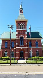
Tate County Courthouse, 201 S. Ward St., Senatobia
|
|

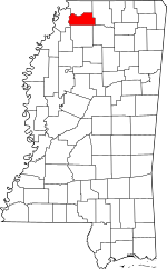
Location within the U.S. state of Mississippi
|
|
 Mississippi's location within the U.S. |
|
| Country | |
| State | |
| Founded | 1873 |
| Seat | Senatobia |
| Largest city | Senatobia |
| Area | |
| • Total | 411 sq mi (1,060 km2) |
| • Land | 405 sq mi (1,050 km2) |
| • Water | 6.2 sq mi (16 km2) 1.5% |
| Population
(2010)
|
|
| • Total | 28,886 |
| • Estimate
(2018)
|
28,759 |
| • Density | 70.28/sq mi (27.14/km2) |
| Time zone | UTC−6 (Central) |
| • Summer (DST) | UTC−5 (CDT) |
| Congressional district | 1st |
Tate County is a special area in the northwestern part of Mississippi, a state in the United States. It's like a big neighborhood with its own local government. In 2010, about 28,886 people lived here. The main town, or "county seat," where the government offices are, is Senatobia.
Tate County was created in 1873, after the American Civil War. It was formed from parts of three other counties: DeSoto, Marshall, and Tunica. The county is named after Thomas Simpson Tate, who was an important early settler in the area.
Tate County is also part of the larger Memphis, TN-MS-AR Metropolitan Statistical Area. This means it's connected to the bigger city of Memphis, which is about 40 miles (64 km) north. The county is also just one county east of the famous Mississippi River. In the 1800s, this area was known for growing a lot of cotton because of its rich soil near the river.
Contents
Exploring Tate County's Geography
Tate County covers a total area of about 411 square miles (1,064 square kilometers). Most of this area, about 405 square miles (1,049 square kilometers), is land. The rest, about 6.2 square miles (16 square kilometers), is water. This makes Tate County one of the smaller counties in Mississippi when you look at its land size.
Main Roads in Tate County
 Interstate 55
 U.S. Route 51
 Mississippi Highway 3
 Mississippi Highway 4
 Mississippi Scenic Highway 304
 Mississippi Highway 305
 Mississippi Highway 306
 Mississippi Highway 740
Neighboring Counties
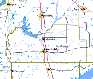
Tate County shares its borders with several other counties:
- DeSoto County (to the north)
- Marshall County (to the east)
- Lafayette County (to the southeast)
- Panola County (to the south)
- Tunica County (to the west)
People of Tate County
| Historical population | |||
|---|---|---|---|
| Census | Pop. | %± | |
| 1880 | 18,721 | — | |
| 1890 | 19,253 | 2.8% | |
| 1900 | 20,618 | 7.1% | |
| 1910 | 19,714 | −4.4% | |
| 1920 | 19,636 | −0.4% | |
| 1930 | 17,671 | −10.0% | |
| 1940 | 19,309 | 9.3% | |
| 1950 | 18,011 | −6.7% | |
| 1960 | 18,138 | 0.7% | |
| 1970 | 18,544 | 2.2% | |
| 1980 | 20,119 | 8.5% | |
| 1990 | 21,432 | 6.5% | |
| 2000 | 25,370 | 18.4% | |
| 2010 | 28,886 | 13.9% | |
| 2018 (est.) | 28,759 | −0.4% | |
| U.S. Decennial Census 1790-1960 1900-1990 1990-2000 2010-2013 |
|||
Population in 2020
In 2020, a special count of people called the 2020 United States Census found that 28,064 people lived in Tate County. There were 10,324 households, which are groups of people living together in a home, and 7,580 families.
| Race | Number of People | Percentage |
|---|---|---|
| White | 18,019 | 64.21% |
| Black or African American | 8,231 | 29.33% |
| Native American | 52 | 0.19% |
| Asian | 63 | 0.22% |
| Pacific Islander | 1 | 0.0% |
| Other/Mixed | 893 | 3.18% |
| Hispanic or Latino | 805 | 2.87% |
Towns and Communities
City
- Senatobia (This is the county seat, the main town)
Town
Smaller Communities
These are smaller places in Tate County that don't have their own city or town government:
Famous People from Tate County
- The famous actor James Earl Jones was born in Arkabutla, Mississippi. He lived there for five years before moving to live with his grandparents in Michigan. He is known for his deep voice and acting in many movies and plays.
See also
 In Spanish: Condado de Tate (Misisipi) para niños
 | Aaron Henry |
 | T. R. M. Howard |
 | Jesse Jackson |


