Panola County, Mississippi facts for kids
Quick facts for kids
Panola County
|
|
|---|---|

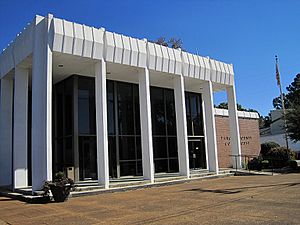
Panola County Courthouse (designed by Pritchard & Nickles)
|
|

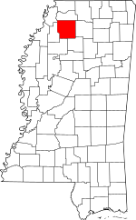
Location within the U.S. state of Mississippi
|
|
 Mississippi's location within the U.S. |
|
| Country | |
| State | |
| Founded | February 9, 1836 |
| Named for | name of Cotton in the Choctaw language |
| Seat | Batesville and Sardis |
| Largest city | Batesville |
| Area | |
| • Total | 705 sq mi (1,830 km2) |
| • Land | 685 sq mi (1,770 km2) |
| • Water | 20 sq mi (50 km2) 2.8% |
| Population
(2020)
|
|
| • Total | 33,208 |
| • Density | 47.10/sq mi (18.187/km2) |
| Time zone | UTC−6 (Central) |
| • Summer (DST) | UTC−5 (CDT) |
| Congressional district | 2nd |
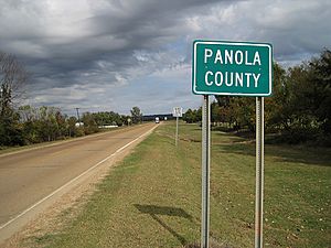
Panola County is a county located in the state of Mississippi. In 2020, about 33,208 people lived there. Its main offices, called county seats, are in Sardis and Batesville.
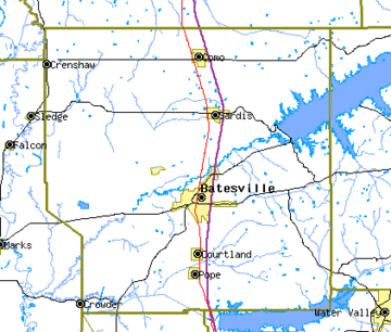
The county is in the northern part of Mississippi. It is just east of the Mississippi Delta. The Tallahatchie River flows through the county. Because the river made travel difficult, two county seats were created.
The name "Panola" comes from ponolo. This word means "thread" in old Choctaw and Chickasaw languages. In modern Choctaw, it means "cotton". Panola was one of twelve large counties formed from land given up by the Chickasaw people in 1832.
History of Panola County
How Panola County Was Formed
Panola County was created on February 9, 1836. This happened after most of the Chickasaw tribe were forced to move west. The state legislature formed it from land that the Chickasaw people had given up in 1832. It was one of twelve new counties made that year in northern Mississippi.
The county's original borders were set by law. Later, on February 1, 1877, Quitman County was formed. It took a small part of Panola's land. This reduced Panola County from about 756 square miles (1,960 km2) to its current size of 705 square miles (1,830 km2).
Population Changes Over Time
From 1850 to 1910, the number of people living in Panola County grew. It went from 11,444 to 31,274. The population reached its highest point in 1940. During this time, most people worked in farming.
After 1940, the population went down until 1980. Many African Americans moved away during the Great Migration. They went to cities in the West and North for jobs. White people also left the countryside. In 2020, about 48.3% of the county's population was African American. About 47.1% was white.
Early Schools in Panola County
In the early days, most children learned at home. There were no public schools. Only richer families could hire teachers or send their sons to special schools. Education often included basic math, reading, and Bible studies. It was against the law to educate enslaved people.
By 1840, there were four small private schools. They had a total of 92 students. In the 1840s, newspapers started to advertise these schools.
In 1846, a new law was passed to create public schools. This law allowed each county to have school leaders. These leaders would hire teachers and manage school funds. However, schools were different from county to county. They depended on how wealthy the county was.
By 1850, Panola County had 18 schools. There were 439 students. This was about four times more than in 1840. Eighteen people listed their job as "educator" or "teacher."
One of the first community schools was the Jones' School. It started in a small log cabin in 1854. It grew over time and moved to different locations. Later, it was known as the "Greasy Smith Schoolhouse." In 1882, it moved to Pleasant Grove.
Two County Seats
Two of the oldest towns in Panola County were Belmont and Panola. They were on opposite sides of the Tallahatchie River. For many years, these towns competed to be the county's main court location.
When the Mississippi and Tennessee railroad (now the Illinois Central railroad) arrived, things changed. Belmont was taken over by Sardis. Panola was taken over by Batesville. The state government then decided to have two court districts for the county. Sardis became the main office for the first district. Batesville became the main office for the second district.
Geography
The county covers a total area of 705 square miles (1,830 km2). About 685 square miles (1,770 km2) is land, and 20 square miles (52 km2) (2.8%) is water.
Major Highways
 Interstate 55
 U.S. Route 51
 Mississippi Highway 3
 Mississippi Highway 6
 Mississippi Highway 35
 U.S. Route 278
 Mississippi Highway 315
Neighboring Counties
- Tunica County (northwest)
- Tate County (north)
- Lafayette County (east)
- Yalobusha County (southeast)
- Tallahatchie County (southwest)
- Quitman County (west)
Demographics
| Historical population | |||
|---|---|---|---|
| Census | Pop. | %± | |
| 1840 | 4,657 | — | |
| 1850 | 11,444 | 145.7% | |
| 1860 | 13,794 | 20.5% | |
| 1870 | 20,754 | 50.5% | |
| 1880 | 28,352 | 36.6% | |
| 1890 | 26,977 | −4.8% | |
| 1900 | 29,027 | 7.6% | |
| 1910 | 31,274 | 7.7% | |
| 1920 | 27,845 | −11.0% | |
| 1930 | 28,648 | 2.9% | |
| 1940 | 34,421 | 20.2% | |
| 1950 | 31,271 | −9.2% | |
| 1960 | 28,791 | −7.9% | |
| 1970 | 26,829 | −6.8% | |
| 1980 | 28,164 | 5.0% | |
| 1990 | 29,996 | 6.5% | |
| 2000 | 34,274 | 14.3% | |
| 2010 | 34,707 | 1.3% | |
| 2020 | 33,208 | −4.3% | |
| 2023 (est.) | 32,669 | −5.9% | |
| U.S. Decennial Census 1790-1960 1900-1990 1990-2000 2010-2013 |
|||
2020 Census Information
| Race | Num. | Perc. |
|---|---|---|
| White | 15,642 | 47.1% |
| Black or African American | 16,035 | 48.29% |
| Native American | 52 | 0.16% |
| Asian | 62 | 0.19% |
| Pacific Islander | 4 | 0.01% |
| Other/Mixed | 735 | 2.21% |
| Hispanic or Latino | 678 | 2.04% |
In 2020, there were 33,208 people living in Panola County. These people made up 12,488 households and 8,512 families.
2010 Census Information
In 2010, Panola County had 34,707 people. About 49.4% were White. About 48.6% were Black or African American. Small numbers of people were Native American (0.2%), Asian (0.2%), or from other races (0.6%). About 0.9% were of two or more races. Around 1.4% of the people were Hispanic or Latino.
Education
The local school board is chosen by voters. This board then picks the school superintendent. The main school districts in Panola County are:
- North Panola School District
- South Panola School District
Communities
City
- Batesville (one of the county seats)
Towns
- Como
- Courtland
- Crenshaw (partly in Quitman County)
- Crowder (mostly in Quitman County)
- Sardis (one of the county seats)
Village
Unincorporated Communities
These are smaller communities that are not officially towns or cities:
- Askew
- Ballentine
- Buxton
- Curtis Station
- Glenville
- Horatio
- Locke Station‡
- Longtown
- Pleasant Grove
- Terza
Ghost Town
See also
 In Spanish: Condado de Panola (Misisipi) para niños
 | William L. Dawson |
 | W. E. B. Du Bois |
 | Harry Belafonte |


