Tallahatchie County, Mississippi facts for kids
Quick facts for kids
Tallahatchie County
|
|
|---|---|

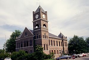
Tallahatchie County courthouse in Sumner
|
|

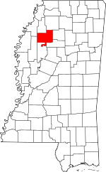
Location within the U.S. state of Mississippi
|
|
 Mississippi's location within the U.S. |
|
| Country | |
| State | |
| Founded | December 31, 1833 |
| Named for | Choctaw word roughly meaning “River of rocks" |
| Seat | Charleston and Sumner |
| Largest city | Charleston |
| Area | |
| • Total | 652 sq mi (1,690 km2) |
| • Land | 645 sq mi (1,670 km2) |
| • Water | 6.9 sq mi (18 km2) 1.1% |
| Population
(2020)
|
|
| • Total | 12,715 |
| • Density | 19.502/sq mi (7.530/km2) |
| Time zone | UTC−6 (Central) |
| • Summer (DST) | UTC−5 (CDT) |
| Congressional district | 2nd |
Tallahatchie County is a county in the state of Mississippi. In 2020, about 12,715 people lived there. Its main towns, called county seats, are Charleston and Sumner.
Tallahatchie County is in the Mississippi Delta region. The Tallahatchie River flows through the county from north to south. This river later joins to form the Yazoo River.
Contents
History
Tallahatchie County was created on December 31, 1833. This happened after most of the Choctaw people were forced to move from their lands. The name "Tallahatchie" comes from the Choctaw language. It means "rock of waters" or "river of rocks."
The county is special because it has two county seats. Charleston is on the east side of the river. Sumner is on the west side. Charleston was the first county seat. Sumner was started later in 1872.
Early Settlements
European Americans founded Charleston in 1837. But people had lived there even before that. Early settlers had built five small communities along the Tillatoba Creek.
In 1833, the United States government opened this land for new settlers. This was after the Choctaw people were moved to Indian Territory. This area is now part of Oklahoma. Old Native American trails went through the county. Many settlers came using a trail called Charley's Trace. This trail came from the Mississippi River and passed near where Charleston is today.
Colonel Thomas Bailey from Kentucky started the first European-American settlement. Other families like the Baileys, Caruthers, and Flemmings joined him. They built homes along the creek. Two towns, DeKalb and Tillatoba, were also founded nearby. Tillatoba was chosen as the county seat for a short time.
A section of land in the middle of these settlements was given to Greenwood LeFlore. He was a main chief of the Choctaw people. He chose to stay in Mississippi on his land. Later, a company bought this land. They planned to build the town of Charleston. They hoped it would become the permanent county seat.
Sumner's Beginnings
J.B. Sumner moved to the area in 1872. He founded the town that is now called Sumner. At first, it was a thick forest. He gave land for a railroad, a park, and the courthouse. In 1873, the first church was built.
From 1882 to 1884, big floods hit the Tallahatchie River. People in Sumner had to use boats to get supplies. A post office opened in 1885. The town officially became a town in 1900.
Sumner's first courthouse was built in 1902. It burned down in 1908, but the records were saved. Then, in 1909, a fire destroyed the entire business area. All the town's records were lost. More floods happened from 1931 to 1933. They covered many farms and destroyed property.
A Difficult Time
In 1955, a sad event happened in nearby Glendora, Mississippi. A young African American boy named Emmett Till was murdered. This event brought national attention to the county. It became an important part of the Civil Rights Movement.
Geography
Tallahatchie County covers about 652 square miles. Most of this is land, about 645 square miles. The rest, about 6.9 square miles, is water. The Tallahatchie River flows through the county.
Major Roads
 U.S. Highway 49
 Mississippi Highway 3
 Mississippi Highway 8
 Mississippi Highway 32
 Mississippi Highway 35
Neighboring Counties
Tallahatchie County shares borders with these counties:
- Quitman County (north)
- Panola County (northeast)
- Yalobusha County (east)
- Grenada County (southeast)
- Leflore County (south)
- Sunflower County (southwest)
- Coahoma County (northwest)
Protected Natural Areas
Parts of these national wildlife refuges are in the county:
- Coldwater River National Wildlife Refuge
- Tallahatchie National Wildlife Refuge
People in Tallahatchie County
| Historical population | |||
|---|---|---|---|
| Census | Pop. | %± | |
| 1840 | 2,985 | — | |
| 1850 | 4,643 | 55.5% | |
| 1860 | 7,890 | 69.9% | |
| 1870 | 7,852 | −0.5% | |
| 1880 | 10,926 | 39.1% | |
| 1890 | 14,361 | 31.4% | |
| 1900 | 19,600 | 36.5% | |
| 1910 | 29,078 | 48.4% | |
| 1920 | 35,953 | 23.6% | |
| 1930 | 35,568 | −1.1% | |
| 1940 | 34,166 | −3.9% | |
| 1950 | 30,486 | −10.8% | |
| 1960 | 24,081 | −21.0% | |
| 1970 | 19,338 | −19.7% | |
| 1980 | 17,157 | −11.3% | |
| 1990 | 15,210 | −11.3% | |
| 2000 | 14,903 | −2.0% | |
| 2010 | 15,378 | 3.2% | |
| 2020 | 12,715 | −17.3% | |
| 2023 (est.) | 11,837 | −23.0% | |
| U.S. Decennial Census 1790-1960 1900-1990 1990-2000 2010-2013 |
|||
In 2020, there were 12,715 people living in Tallahatchie County. There were about 4,369 households.
Who Lives Here?
| Race | Number | Percent |
|---|---|---|
| White | 4,727 | 37.18% |
| Black or African American | 7,390 | 58.12% |
| Native American | 4 | 0.03% |
| Asian | 10 | 0.08% |
| Pacific Islander | 3 | 0.02% |
| Other/Mixed | 156 | 1.23% |
| Hispanic or Latino | 425 | 3.34% |
In 2010, about 56.4% of the people were Black or African American. About 38.9% were White. People of Hispanic or Latino background made up 5.6% of the population.
Education
Public Schools
- East Tallahatchie School District (in Charleston)
- Charleston High School
- West Tallahatchie School District (in Webb)
- West Tallahatchie High School
Colleges
Coahoma Community College is the local community college.
Communities
Cities
- Charleston (a county seat)
Towns
Villages
Other Communities
These are smaller places that are not officially cities, towns, or villages:
- Black Bayou
- Brazil
- Cascilla
- Cowart
- Effie
- Enid
- Leverett
- Macel
- Minter City (partly in Leflore County)
- Paynes
- Philipp
- Swan Lake
- Teasdale
- Tippo
- Vance (partly in Quitman County)
- Whitehead
Old Towns (Ghost Towns)
These towns no longer exist:
Images for kids
See also
 In Spanish: Condado de Tallahatchie (Misisipi) para niños
 | William M. Jackson |
 | Juan E. Gilbert |
 | Neil deGrasse Tyson |


